Tiffin Topo Map Missouri
To zoom in, hover over the map of Tiffin
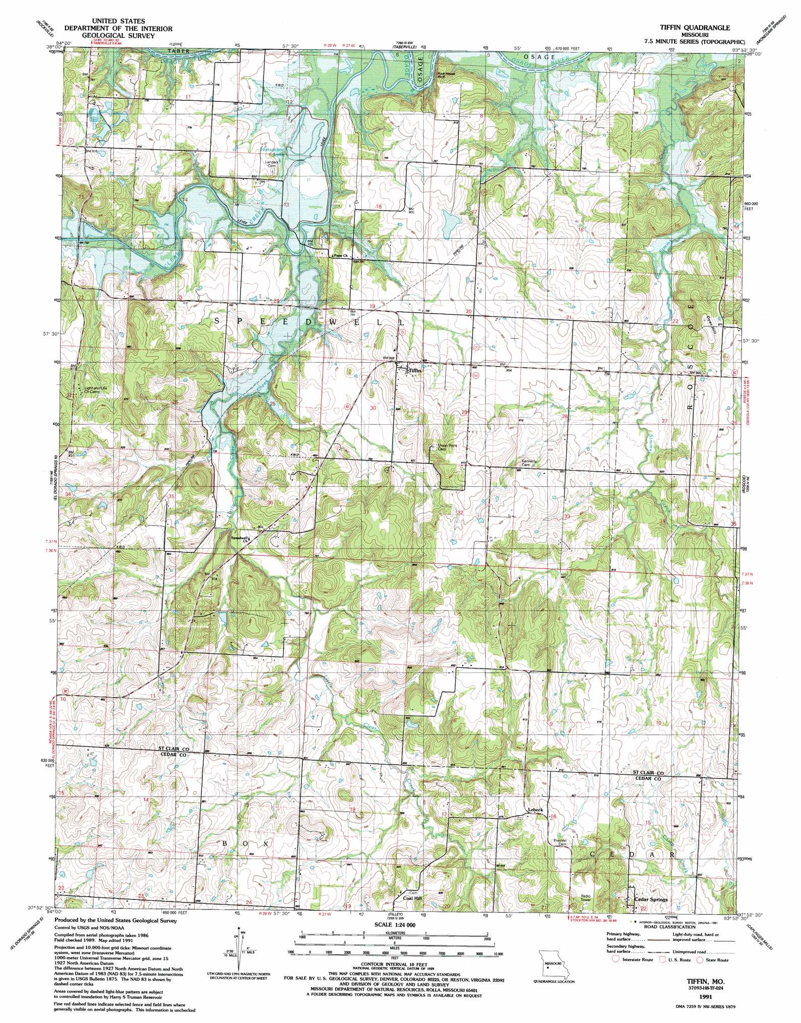
USGS Topo Quad 37093h8 - 1:24,000 scale
| Topo Map Name: | Tiffin |
| USGS Topo Quad ID: | 37093h8 |
| Print Size: | ca. 21 1/4" wide x 27" high |
| Southeast Coordinates: | 37.875° N latitude / 93.875° W longitude |
| Map Center Coordinates: | 37.9375° N latitude / 93.9375° W longitude |
| U.S. State: | MO |
| Filename: | o37093h8.jpg |
| Download Map JPG Image: | Tiffin topo map 1:24,000 scale |
| Map Type: | Topographic |
| Topo Series: | 7.5´ |
| Map Scale: | 1:24,000 |
| Source of Map Images: | United States Geological Survey (USGS) |
| Alternate Map Versions: |
Tiffin MO 1937 Download PDF Buy paper map Tiffin MO 1949, updated 1955 Download PDF Buy paper map Tiffin MO 1949, updated 1955 Download PDF Buy paper map Tiffin MO 1991, updated 1991 Download PDF Buy paper map Tiffin MO 2011 Download PDF Buy paper map Tiffin MO 2015 Download PDF Buy paper map |
1:24,000 Topo Quads surrounding Tiffin
Pleasant Gap |
Appleton City |
Monegaw Springs Nw |
Ohio |
Lowry City |
Papinsville |
Rockville |
Taberville |
Monegaw Springs |
Osceola |
Harwood |
Eldorado Springs North |
Tiffin |
Roscoe |
Vista |
Dederick |
Eldorado Springs South |
Filley |
Caplinger Mills |
Arnica |
Bellamy |
Montevallo |
Wagoner |
Stockton |
Bearcreek |
> Back to 37093e1 at 1:100,000 scale
> Back to 37092a1 at 1:250,000 scale
> Back to U.S. Topo Maps home
Tiffin topo map: Gazetteer
Tiffin: Cliffs
Rock House Bluff elevation 224m 734′Tiffin: Lakes
Horseshoe Lake elevation 216m 708′Tiffin: Populated Places
Coal Hill elevation 285m 935′Ebb (historical) elevation 256m 839′
Lebeck elevation 284m 931′
Pape elevation 238m 780′
Tiffin elevation 257m 843′
Tiffin: Post Offices
Ebb Post Office elevation 256m 839′Tiffin: Streams
Clear Creek elevation 216m 708′Little Clear Creek elevation 216m 708′
Tiffin: Summits
Oyer Hill elevation 278m 912′Tiffin digital topo map on disk
Buy this Tiffin topo map showing relief, roads, GPS coordinates and other geographical features, as a high-resolution digital map file on DVD: