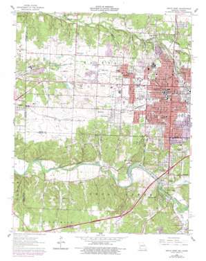
Joplin West Topo Map Missouri
To zoom in, hover over the map of Joplin West
USGS Topo Quad 37094a5 - 1:24,000 scale
| Topo Map Name: | Joplin West |
| USGS Topo Quad ID: | 37094a5 |
| Print Size: | ca. 21 1/4" wide x 27" high |
| Southeast Coordinates: | 37° N latitude / 94.5° W longitude |
| Map Center Coordinates: | 37.0625° N latitude / 94.5625° W longitude |
| U.S. States: | MO, KS |
| Filename: | o37094a5.jpg |
| Download Map JPG Image: | Joplin West topo map 1:24,000 scale |
| Map Type: | Topographic |
| Topo Series: | 7.5´ |
| Map Scale: | 1:24,000 |
| Source of Map Images: | United States Geological Survey (USGS) |
| Alternate Map Versions: |
Joplin West MO 1962, updated 1964 Download PDF Buy paper map Joplin West MO 1962, updated 1979 Download PDF Buy paper map Joplin West MO 1980, updated 1982 Download PDF Buy paper map Joplin West MO 2010 Download PDF Buy paper map Joplin West MO 2011 Download PDF Buy paper map Joplin West MO 2015 Download PDF Buy paper map |
1:24,000 Topo Quads surrounding Joplin West
> Back to 37094a1 at 1:100,000 scale
> Back to 37094a1 at 1:250,000 scale
> Back to U.S. Topo Maps home
Joplin West topo map: Gazetteer
Joplin West: Bridges
Fillmore Bridge elevation 259m 849′Joplin West: Dams
Grand Falls Dam elevation 262m 859′Joplin West: Falls
Shoal Creek Falls elevation 262m 859′Joplin West: Parks
Cunningham Park elevation 317m 1040′Garvin Park elevation 311m 1020′
Jungo Stadium elevation 314m 1030′
Landreth Park elevation 297m 974′
McClelland Park elevation 282m 925′
Schifferdecker Park elevation 316m 1036′
Spiva Park elevation 274m 898′
Joplin West: Populated Places
Belle Center elevation 291m 954′Belleville elevation 263m 862′
Blendville (historical) elevation 321m 1053′
Central City elevation 301m 987′
Chitwood elevation 309m 1013′
Cliff Village elevation 290m 951′
Dennis Acres elevation 321m 1053′
Grand Falls Plaza elevation 273m 895′
Gregg elevation 285m 935′
Iron Gates elevation 314m 1030′
Joplin elevation 306m 1003′
Lone Elm elevation 285m 935′
Midway elevation 325m 1066′
Redings Mill elevation 321m 1053′
Shoal Creek Drive elevation 315m 1033′
West Joplin elevation 305m 1000′
Joplin West: Reservoirs
Joplin Water Supply Lake elevation 262m 859′Joplin West: Streams
Beef Branch elevation 275m 902′Jacobs Branch elevation 274m 898′
Joplin Creek elevation 278m 912′
Silver Creek elevation 271m 889′
Spring Branch elevation 269m 882′
Spring Branch elevation 269m 882′
Spring Creek elevation 271m 889′
Joplin West: Valleys
Chitwood Hollow elevation 271m 889′East Hollow elevation 268m 879′
Gordon Hollow elevation 261m 856′
Leadville Hollow elevation 271m 889′
Lone Elm Hollow elevation 274m 898′
Opossum Hollow elevation 274m 898′
Reddish Hollow elevation 259m 849′
Roaring Spring Hollow elevation 259m 849′
Tanyard Hollow elevation 268m 879′
West Hollow elevation 261m 856′
Joplin West digital topo map on disk
Buy this Joplin West topo map showing relief, roads, GPS coordinates and other geographical features, as a high-resolution digital map file on DVD:


