South Mound Topo Map Kansas
To zoom in, hover over the map of South Mound
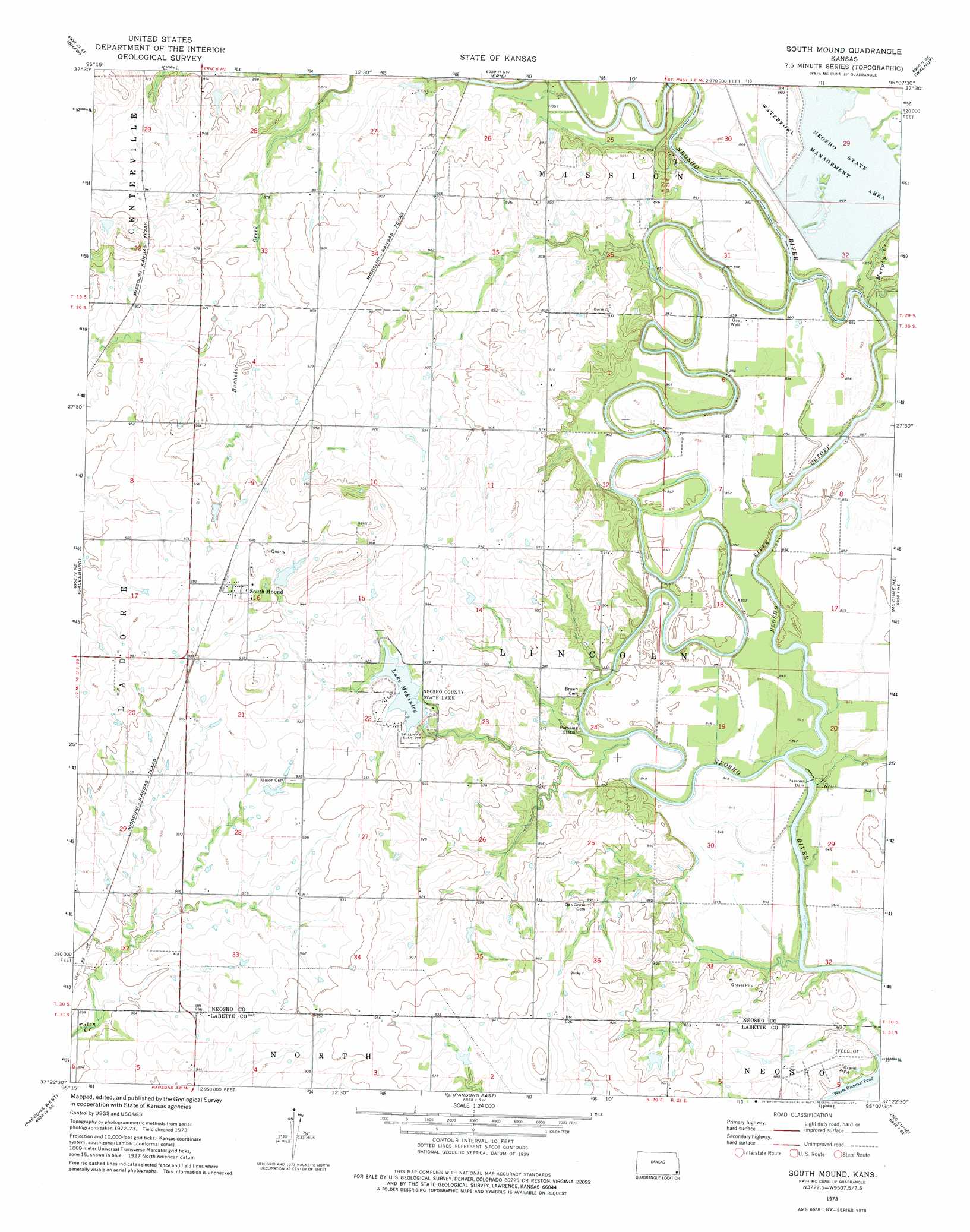
USGS Topo Quad 37095d2 - 1:24,000 scale
| Topo Map Name: | South Mound |
| USGS Topo Quad ID: | 37095d2 |
| Print Size: | ca. 21 1/4" wide x 27" high |
| Southeast Coordinates: | 37.375° N latitude / 95.125° W longitude |
| Map Center Coordinates: | 37.4375° N latitude / 95.1875° W longitude |
| U.S. State: | KS |
| Filename: | o37095d2.jpg |
| Download Map JPG Image: | South Mound topo map 1:24,000 scale |
| Map Type: | Topographic |
| Topo Series: | 7.5´ |
| Map Scale: | 1:24,000 |
| Source of Map Images: | United States Geological Survey (USGS) |
| Alternate Map Versions: |
South Mound KS 1973, updated 1975 Download PDF Buy paper map South Mound KS 2010 Download PDF Buy paper map South Mound KS 2012 Download PDF Buy paper map South Mound KS 2015 Download PDF Buy paper map |
1:24,000 Topo Quads surrounding South Mound
Chanute |
Rollin |
Stark |
Porterville |
Hepler |
Earlton |
Shaw |
Erie |
Walnut |
Brazilton |
Thayer |
Galesburg |
South Mound |
Mccune Ne |
Grindstone Creek |
Dennis |
Parsons West |
Parsons East |
Mccune |
West Mineral |
Mound Valley |
Altamont |
Labette |
Oswego |
Hallowell |
> Back to 37095a1 at 1:100,000 scale
> Back to 37094a1 at 1:250,000 scale
> Back to U.S. Topo Maps home
South Mound topo map: Gazetteer
South Mound: Bends
Neosho River Cutoff elevation 256m 839′South Mound: Dams
Neosho County State Park Dam elevation 276m 905′Parsons Dam elevation 254m 833′
South Mound: Lakes
Grass Lake (historical) elevation 257m 843′Halfmoon Lake (historical) elevation 258m 846′
South Mound: Parks
Neosho State Fishing Lake elevation 275m 902′Neosho Wildlife Area elevation 261m 856′
South Mound: Populated Places
South Mound elevation 301m 987′South Mound: Reservoirs
Lake McKinley elevation 276m 905′South Mound: Streams
Brogan Creek elevation 261m 856′Murphy Creek elevation 255m 836′
South Mound digital topo map on disk
Buy this South Mound topo map showing relief, roads, GPS coordinates and other geographical features, as a high-resolution digital map file on DVD: