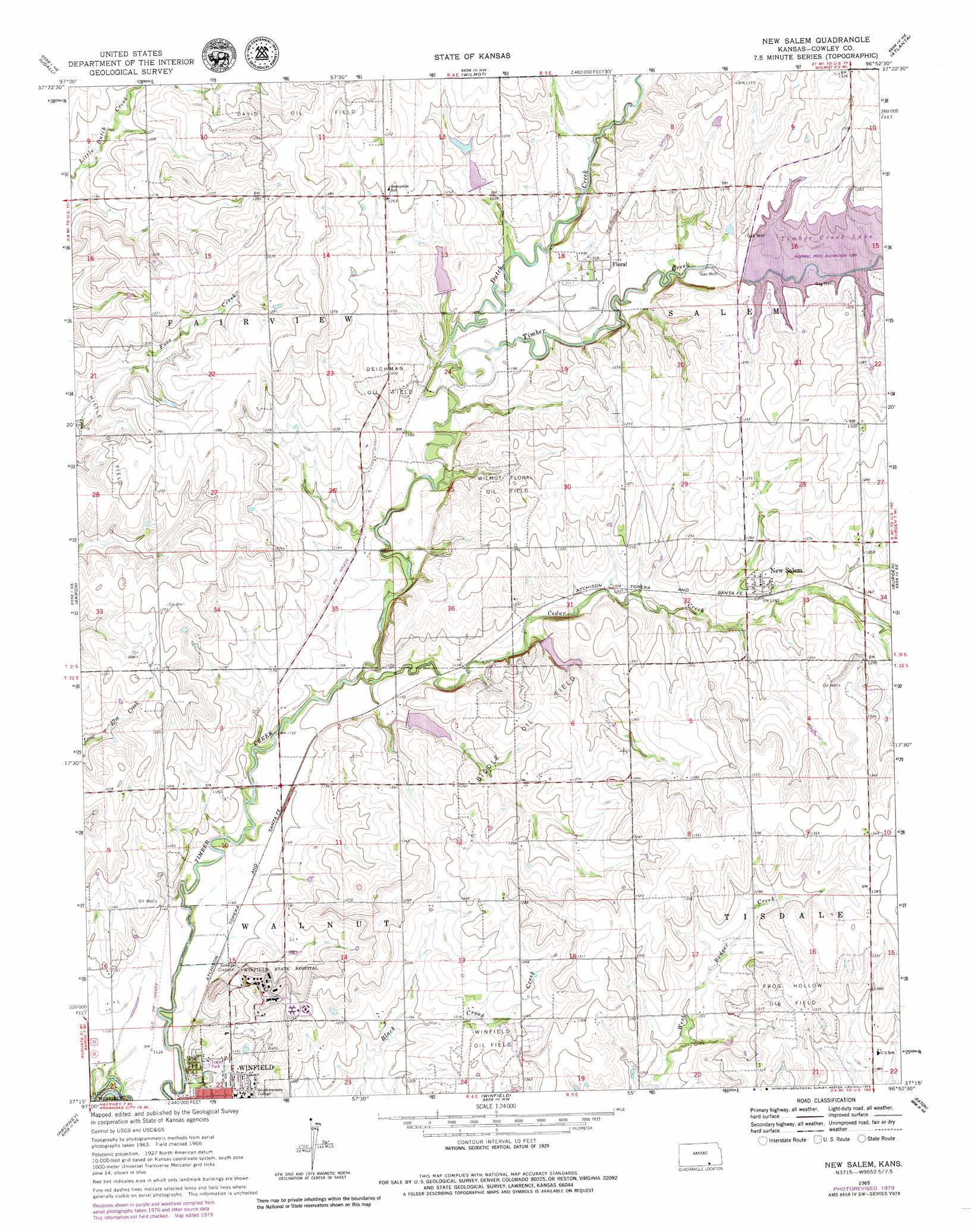
New Salem Topo Map Kansas
To zoom in, hover over the map of New Salem
USGS Topo Quad 37096c8 - 1:24,000 scale
| Topo Map Name: | New Salem |
| USGS Topo Quad ID: | 37096c8 |
| Print Size: | ca. 21 1/4" wide x 27" high |
| Southeast Coordinates: | 37.25° N latitude / 96.875° W longitude |
| Map Center Coordinates: | 37.3125° N latitude / 96.9375° W longitude |
| U.S. State: | KS |
| Filename: | o37096c8.jpg |
| Download Map JPG Image: | New Salem topo map 1:24,000 scale |
| Map Type: | Topographic |
| Topo Series: | 7.5´ |
| Map Scale: | 1:24,000 |
| Source of Map Images: | United States Geological Survey (USGS) |
| Alternate Map Versions: |
New Salem KS 1965, updated 1966 Download PDF Buy paper map New Salem KS 1965, updated 1979 Download PDF Buy paper map New Salem KS 2010 Download PDF Buy paper map New Salem KS 2012 Download PDF Buy paper map New Salem KS 2015 Download PDF Buy paper map |
1:24,000 Topo Quads surrounding New Salem
Rose Hill |
Douglass |
Gordon |
Augusta Se |
Latham |
Mulvane |
Udall |
Wilmot |
Atlanta |
Cambridge Nw |
Oxford |
Akron |
New Salem |
Burden |
Cambridge |
Adamsville |
Hackney |
Winfield |
Eaton |
Dexter |
Geuda Springs |
Arkansas City |
Silverdale |
Maple City |
Dexter Sw |
> Back to 37096a1 at 1:100,000 scale
> Back to 37096a1 at 1:250,000 scale
> Back to U.S. Topo Maps home
New Salem topo map: Gazetteer
New Salem: Oilfields
Biddle Oil Field elevation 383m 1256′Deichman Oil Field elevation 374m 1227′
Hittle Oil Field elevation 382m 1253′
Wilmot Floral Oil Field elevation 374m 1227′
New Salem: Populated Places
Floral elevation 375m 1230′New Salem elevation 380m 1246′
New Salem: Reservoirs
Timber Creek Lake elevation 371m 1217′New Salem: Streams
Cedar Creek elevation 348m 1141′Dutch Creek elevation 360m 1181′
New Salem digital topo map on disk
Buy this New Salem topo map showing relief, roads, GPS coordinates and other geographical features, as a high-resolution digital map file on DVD: