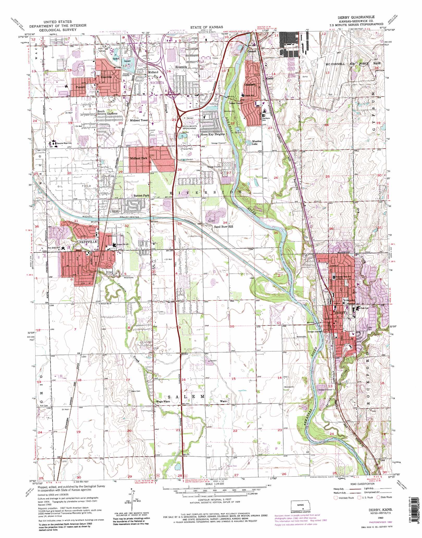
Derby Topo Map Kansas
To zoom in, hover over the map of Derby
USGS Topo Quad 37097e3 - 1:24,000 scale
| Topo Map Name: | Derby |
| USGS Topo Quad ID: | 37097e3 |
| Print Size: | ca. 21 1/4" wide x 27" high |
| Southeast Coordinates: | 37.5° N latitude / 97.25° W longitude |
| Map Center Coordinates: | 37.5625° N latitude / 97.3125° W longitude |
| U.S. State: | KS |
| Filename: | o37097e3.jpg |
| Download Map JPG Image: | Derby topo map 1:24,000 scale |
| Map Type: | Topographic |
| Topo Series: | 7.5´ |
| Map Scale: | 1:24,000 |
| Source of Map Images: | United States Geological Survey (USGS) |
| Alternate Map Versions: |
Derby KS 1956, updated 1957 Download PDF Buy paper map Derby KS 1960, updated 1961 Download PDF Buy paper map Derby KS 1960, updated 1971 Download PDF Buy paper map Derby KS 1960, updated 1976 Download PDF Buy paper map Derby KS 1960, updated 1983 Download PDF Buy paper map Derby KS 2010 Download PDF Buy paper map Derby KS 2012 Download PDF Buy paper map Derby KS 2015 Download PDF Buy paper map |
1:24,000 Topo Quads surrounding Derby
Colwich |
Maize |
Valley Center |
Greenwich |
Benton |
Goddard |
Wichita West |
Wichita East |
Andover |
Santa Fe Lake |
Clearwater |
Bayneville |
Derby |
Rose Hill |
Douglass |
Millerton |
Zyba |
Belle Plaine |
Mulvane |
Udall |
Mayfield |
Wellington |
Dalton |
Oxford |
Akron |
> Back to 37097e1 at 1:100,000 scale
> Back to 37096a1 at 1:250,000 scale
> Back to U.S. Topo Maps home
Derby topo map: Gazetteer
Derby: Airports
Beyer Farm Airport elevation 412m 1351′Westport Auxiliary Airport elevation 389m 1276′
Derby: Canals
Wichita-Valley Center Floodway elevation 378m 1240′Derby: Lakes
Meadow Lake elevation 385m 1263′Derby: Parks
Emery Park elevation 387m 1269′English Park elevation 395m 1295′
Hand Park elevation 382m 1253′
Riley Park elevation 386m 1266′
Derby: Populated Places
Air Capital Mobile Home Park elevation 392m 1286′Audora Mobile Home Park elevation 389m 1276′
Cambridge Mobile Home Park elevation 387m 1269′
Caudill Mobile Home Park elevation 389m 1276′
Cedar Ridge Mobile Home Park elevation 388m 1272′
Conestoga Mobile Home Park elevation 387m 1269′
Connell elevation 400m 1312′
Derby elevation 394m 1292′
El Caudillo Mobile Home Park elevation 389m 1276′
Englewood Mobile Home Park elevation 392m 1286′
Glen Acres Mobile Home Park elevation 387m 1269′
Glenville elevation 389m 1276′
Harbor Mobile Home Park elevation 387m 1269′
Hardison Shady Acres Mobile Home Park elevation 387m 1269′
Haysville elevation 384m 1259′
Keeler elevation 399m 1309′
Kuhns Mobile Home Park elevation 389m 1276′
Lakeview Mobile Home Park elevation 389m 1276′
Lamplighter Mobile Home Park elevation 387m 1269′
Midland elevation 389m 1276′
Midland Park elevation 387m 1269′
Midland Tower elevation 388m 1272′
Mobile Manor Estates Mobile Home Park elevation 391m 1282′
Mona Kay Heights elevation 386m 1266′
Oaklawn elevation 388m 1272′
Oakwood Manor Mobile Home Park elevation 388m 1272′
Pacesetter Mobile Home Park elevation 389m 1276′
Park Avenue Estates Mobile Home Park elevation 386m 1266′
Peachwood Manor Mobile Home Park elevation 384m 1259′
Pinaire Mobile Home Park elevation 386m 1266′
Purcell elevation 389m 1276′
River Oaks Mobile Home Park elevation 385m 1263′
Riverside elevation 388m 1272′
Riverside Mobile Home Park elevation 388m 1272′
Rolling Green Mobile Home Park elevation 384m 1259′
Sand Burr Hill elevation 383m 1256′
Sherwood Acres Mobile Home Park elevation 388m 1272′
Silver Spur Mobile Home Park elevation 391m 1282′
South Seneca Gardens elevation 388m 1272′
Southborough Estates Mobile Home Park elevation 389m 1276′
Sunset Park elevation 385m 1263′
Sunview Mobile Home Park elevation 388m 1272′
Sycamore Square Mobile Home Park elevation 389m 1276′
The Woodlands Mobile Home Park elevation 390m 1279′
Thompsons Mobile Home Park elevation 382m 1253′
Timbercreek Mobile Home Park elevation 387m 1269′
Twin Oaks Estates Mobile Home Park elevation 392m 1286′
Waco elevation 378m 1240′
Wayne Smith Mobile Home Park elevation 389m 1276′
Wego-Waco elevation 380m 1246′
Welcome Home Community Mobile Home Park elevation 389m 1276′
Willowood Estates Mobile Home Park elevation 389m 1276′
Young Mobile Home Park elevation 386m 1266′
Derby: Post Offices
Derby Post Office elevation 399m 1309′Haysville Post Office elevation 384m 1259′
Derby: Streams
Big Slough elevation 380m 1246′Dry Creek elevation 378m 1240′
Spring Creek elevation 373m 1223′
Derby digital topo map on disk
Buy this Derby topo map showing relief, roads, GPS coordinates and other geographical features, as a high-resolution digital map file on DVD: