Beaty Canyon Topo Map Colorado
To zoom in, hover over the map of Beaty Canyon
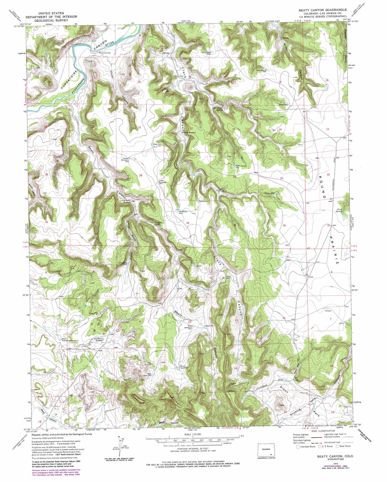
USGS Topo Quad 37103e5 - 1:24,000 scale
| Topo Map Name: | Beaty Canyon |
| USGS Topo Quad ID: | 37103e5 |
| Print Size: | ca. 21 1/4" wide x 27" high |
| Southeast Coordinates: | 37.5° N latitude / 103.5° W longitude |
| Map Center Coordinates: | 37.5625° N latitude / 103.5625° W longitude |
| U.S. State: | CO |
| Filename: | o37103e5.jpg |
| Download Map JPG Image: | Beaty Canyon topo map 1:24,000 scale |
| Map Type: | Topographic |
| Topo Series: | 7.5´ |
| Map Scale: | 1:24,000 |
| Source of Map Images: | United States Geological Survey (USGS) |
| Alternate Map Versions: |
Beaty Canyon CO 1972, updated 1976 Download PDF Buy paper map Beaty Canyon CO 1972, updated 1976 Download PDF Buy paper map Beaty Canyon CO 1972, updated 1985 Download PDF Buy paper map Beaty Canyon CO 1972, updated 1985 Download PDF Buy paper map Beaty Canyon CO 1996, updated 2000 Download PDF Buy paper map Beaty Canyon CO 2011 Download PDF Buy paper map Beaty Canyon CO 2013 Download PDF Buy paper map Beaty Canyon CO 2016 Download PDF Buy paper map |
| FStopo: | US Forest Service topo Beaty Canyon is available: Download FStopo PDF Download FStopo TIF |
1:24,000 Topo Quads surrounding Beaty Canyon
Timpas |
La Junta Sw |
La Junta Se |
Higbee |
Turkey Canyon |
Sheep Canyon |
Packers Gap |
Riley Canyon |
Corbin Canyon |
Rock Canyon |
Stage Canyon |
O V Mesa |
Beaty Canyon |
Lost Canyon |
Brown Canyon |
Doss Canyon North |
Johnson Canyon |
Plum Canyon |
Icehouse Canyon |
Robbers Roost Canyon |
Doss Canyon South |
Humbar Spring |
Villegreen |
Cherry Canyon |
Kim North |
> Back to 37103e1 at 1:100,000 scale
> Back to 37102a1 at 1:250,000 scale
> Back to U.S. Topo Maps home
Beaty Canyon topo map: Gazetteer
Beaty Canyon: Areas
Round Prairie elevation 1496m 4908′Beaty Canyon: Dams
Dunbar Dam elevation 1458m 4783′East Dam elevation 1465m 4806′
Goat Ranch Dam elevation 1445m 4740′
Little Beaty Dam elevation 1442m 4730′
Northwest Dam elevation 1446m 4744′
Reed Dam elevation 1476m 4842′
Road Dam elevation 1457m 4780′
South Vaya Dam elevation 1492m 4895′
Telephone Dam elevation 1476m 4842′
Trail Dam elevation 1465m 4806′
West Vaya Dam elevation 1500m 4921′
Beaty Canyon: Flats
Piñon Park elevation 1503m 4931′Beaty Canyon: Gaps
Piñon Park Hill elevation 1540m 5052′Beaty Canyon: Springs
Fritz Spring elevation 1476m 4842′Goat Ranch Spring elevation 1384m 4540′
Sumpter Spring elevation 1404m 4606′
Beaty Canyon: Summits
Clark Hill elevation 1611m 5285′Beaty Canyon: Valleys
Beaty Canyon elevation 1335m 4379′Goat Canyon elevation 1359m 4458′
Little Beaty Canyon elevation 1396m 4580′
South Canyon elevation 1328m 4356′
Beaty Canyon digital topo map on disk
Buy this Beaty Canyon topo map showing relief, roads, GPS coordinates and other geographical features, as a high-resolution digital map file on DVD: