Trinidad East Topo Map Colorado
To zoom in, hover over the map of Trinidad East
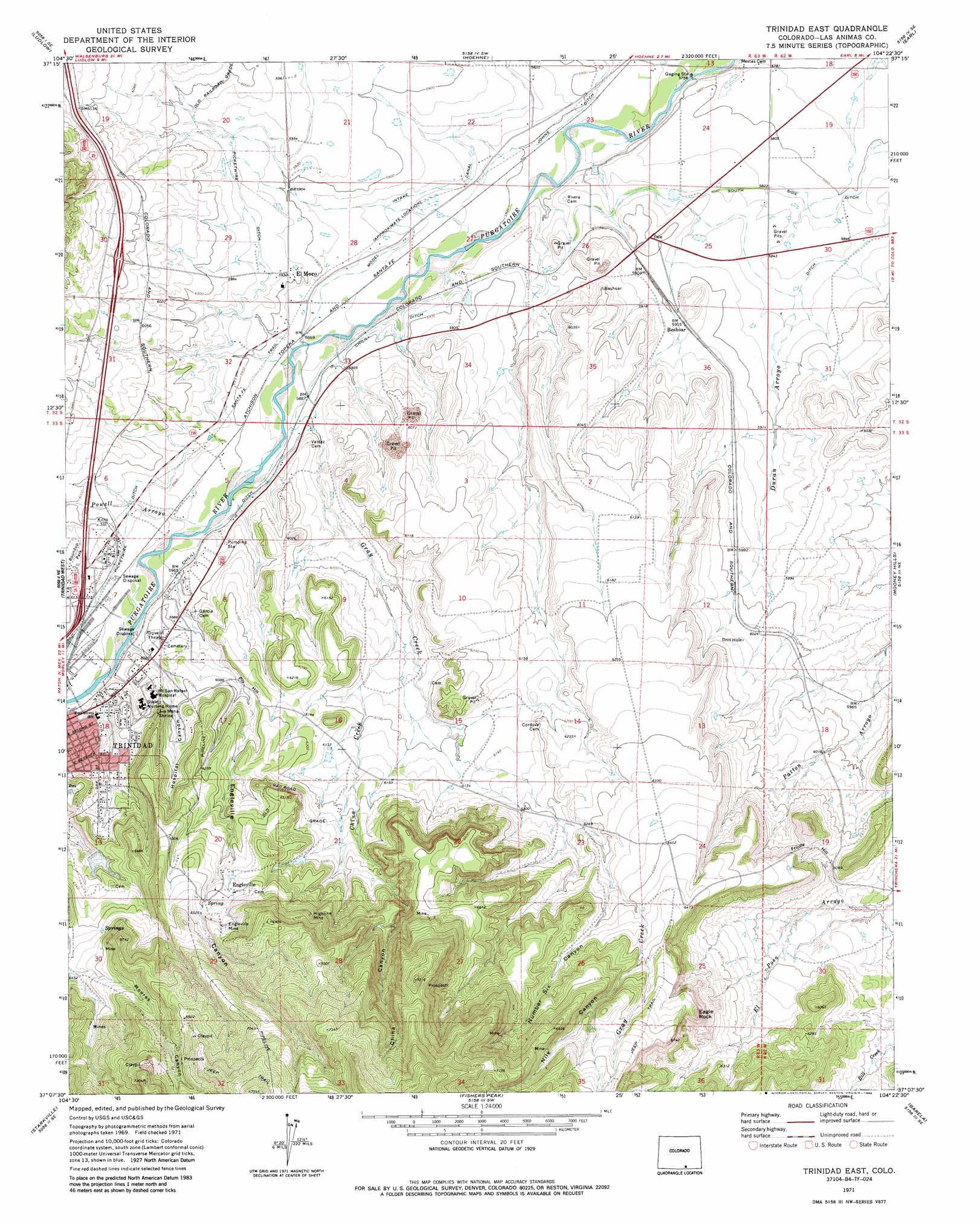
USGS Topo Quad 37104b4 - 1:24,000 scale
| Topo Map Name: | Trinidad East |
| USGS Topo Quad ID: | 37104b4 |
| Print Size: | ca. 21 1/4" wide x 27" high |
| Southeast Coordinates: | 37.125° N latitude / 104.375° W longitude |
| Map Center Coordinates: | 37.1875° N latitude / 104.4375° W longitude |
| U.S. State: | CO |
| Filename: | o37104b4.jpg |
| Download Map JPG Image: | Trinidad East topo map 1:24,000 scale |
| Map Type: | Topographic |
| Topo Series: | 7.5´ |
| Map Scale: | 1:24,000 |
| Source of Map Images: | United States Geological Survey (USGS) |
| Alternate Map Versions: |
Trinidad East CO 1971, updated 1974 Download PDF Buy paper map Trinidad East CO 1971, updated 1986 Download PDF Buy paper map Trinidad East CO 1971, updated 1986 Download PDF Buy paper map Trinidad East CO 2010 Download PDF Buy paper map Trinidad East CO 2013 Download PDF Buy paper map Trinidad East CO 2016 Download PDF Buy paper map |
1:24,000 Topo Quads surrounding Trinidad East
Aguilar |
The Hogback |
Vega Corral |
Seven Lakes Reservoir |
Tyrone |
Delagua |
Ludlow |
Hoehne |
Earl |
Model |
Madrid |
Trinidad West |
Trinidad East |
Mooney Hills |
Patterson Crossing |
Valdez |
Starkville |
Fishers Peak |
Barela |
Abeyta |
Mcwilliams Canyon |
Tin Pan Canyon |
Raton |
Yankee |
Dale Mountain |
> Back to 37104a1 at 1:100,000 scale
> Back to 37104a1 at 1:250,000 scale
> Back to U.S. Topo Maps home
Trinidad East topo map: Gazetteer
Trinidad East: Airports
Mount San Rafael Heliport elevation 1806m 5925′Trinidad East: Canals
Chilili Ditch elevation 1799m 5902′Picketwire Ditch elevation 1812m 5944′
Trinidad East: Dams
Mike Gagliardi Dam elevation 1783m 5849′Trinidad East: Mines
Engle Mine elevation 2028m 6653′Engleville Mine elevation 2020m 6627′
Helen Mine elevation 1828m 5997′
Highland Mine elevation 2003m 6571′
Highline Mine elevation 2018m 6620′
Welte Pit elevation 2139m 7017′
Trinidad East: Pillars
Eagle Rock elevation 2049m 6722′Trinidad East: Populated Places
Beshoar elevation 1805m 5921′El Moro elevation 1806m 5925′
Engleville elevation 1982m 6502′
Trinidad East: Reservoirs
Mike Gagliardi Reservoir elevation 1783m 5849′Trinidad East: Streams
China Creek elevation 1820m 5971′Duran Arroyo elevation 1784m 5853′
Gray Creek elevation 1791m 5875′
Powell Arroyo elevation 1801m 5908′
Trinidad East: Summits
Frijole Hill elevation 1896m 6220′Pio Hill elevation 1861m 6105′
Trinidad East: Valleys
China Canyon elevation 1901m 6236′Engleville Canyon elevation 1818m 5964′
Hospital Canyon elevation 1842m 6043′
Nile Canyon elevation 1983m 6505′
Number Six Canyon elevation 1939m 6361′
Trinidad East digital topo map on disk
Buy this Trinidad East topo map showing relief, roads, GPS coordinates and other geographical features, as a high-resolution digital map file on DVD: