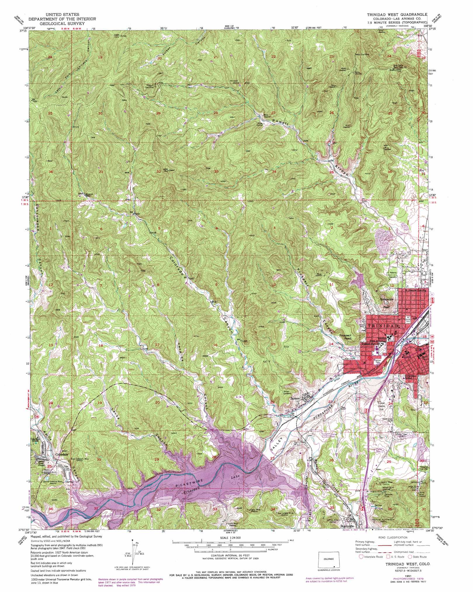
Trinidad West Topo Map Colorado
To zoom in, hover over the map of Trinidad West
USGS Topo Quad 37104b5 - 1:24,000 scale
| Topo Map Name: | Trinidad West |
| USGS Topo Quad ID: | 37104b5 |
| Print Size: | ca. 21 1/4" wide x 27" high |
| Southeast Coordinates: | 37.125° N latitude / 104.5° W longitude |
| Map Center Coordinates: | 37.1875° N latitude / 104.5625° W longitude |
| U.S. State: | CO |
| Filename: | o37104b5.jpg |
| Download Map JPG Image: | Trinidad West topo map 1:24,000 scale |
| Map Type: | Topographic |
| Topo Series: | 7.5´ |
| Map Scale: | 1:24,000 |
| Source of Map Images: | United States Geological Survey (USGS) |
| Alternate Map Versions: |
Trinidad CO 1951, updated 1953 Download PDF Buy paper map Trinidad CO 1951, updated 1953 Download PDF Buy paper map Trinidad CO 1951, updated 1964 Download PDF Buy paper map Trinidad CO 1951, updated 1964 Download PDF Buy paper map Trinidad West CO 1951, updated 1979 Download PDF Buy paper map Trinidad West CO 2010 Download PDF Buy paper map Trinidad West CO 2013 Download PDF Buy paper map Trinidad West CO 2016 Download PDF Buy paper map |
1:24,000 Topo Quads surrounding Trinidad West
Santa Clara |
Aguilar |
The Hogback |
Vega Corral |
Seven Lakes Reservoir |
Gulnare |
Delagua |
Ludlow |
Hoehne |
Earl |
Weston |
Madrid |
Trinidad West |
Trinidad East |
Mooney Hills |
Little Pine Canyon |
Valdez |
Starkville |
Fishers Peak |
Barela |
Caliente Canyon North |
Mcwilliams Canyon |
Tin Pan Canyon |
Raton |
Yankee |
> Back to 37104a1 at 1:100,000 scale
> Back to 37104a1 at 1:250,000 scale
> Back to U.S. Topo Maps home
Trinidad West topo map: Gazetteer
Trinidad West: Canals
Lopez Ditch elevation 1849m 6066′Trinidad West: Cliffs
Prospect Point elevation 1960m 6430′Trinidad West: Dams
Fisher Peak Detention FPC-1 Dam elevation 1910m 6266′Fisher Peak Detention FPC-2 Dam elevation 1871m 6138′
Pinon Canyon Dam Colorado elevation 1900m 6233′
Trinidad Dam elevation 1859m 6099′
Trinidad West: Mines
Animas Mine elevation 1872m 6141′Baldy Coal Mine elevation 2085m 6840′
Banner Mine elevation 2172m 7125′
Bear Canyon Mine elevation 2005m 6578′
Black Diamond Mine elevation 1825m 5987′
Bowen Mine elevation 2109m 6919′
East Cokedale Mine elevation 1944m 6377′
Fairview Mine elevation 1922m 6305′
Flagg Mine elevation 2048m 6719′
Francisco Mine elevation 1916m 6286′
Henderson Mine elevation 1965m 6446′
Jeffryes Mine elevation 1936m 6351′
Klag Mine elevation 1900m 6233′
La Belle Mine elevation 1940m 6364′
Leone Mine elevation 1977m 6486′
Main Cokedale Mine elevation 1932m 6338′
McLaughlin Mine elevation 1963m 6440′
McPherson Mine elevation 1928m 6325′
Moore Mine elevation 1991m 6532′
New La Belle Mine elevation 1950m 6397′
New Mary Mine elevation 1961m 6433′
Old Miller Mine elevation 2056m 6745′
Peacock Coal Mine elevation 2164m 7099′
Piedmont Mine elevation 1900m 6233′
Santa Fe Pit elevation 1944m 6377′
Second Cokedale Mine elevation 1934m 6345′
Sherman Mine elevation 2067m 6781′
Sopris Mine elevation 1921m 6302′
Starkville Mine elevation 1965m 6446′
Starkville Number 1 Coal Mine elevation 1986m 6515′
Stevens Mine elevation 1957m 6420′
Valley Mine elevation 1900m 6233′
Viola Mine elevation 1926m 6318′
Williams Mine elevation 1902m 6240′
Trinidad West: Parks
Central Park elevation 1833m 6013′Kit Carson Park elevation 1842m 6043′
Memorial Square elevation 1846m 6056′
Roundup Park elevation 1847m 6059′
Trinidad Lake State Park elevation 1917m 6289′
Trinidad West: Populated Places
Cokedale elevation 1926m 6318′Jansen elevation 1876m 6154′
Piedmont (historical) elevation 1900m 6233′
Saint Thomas (historical) elevation 1900m 6233′
Sopris (historical) elevation 1900m 6233′
Sopris Plaza (historical) elevation 1900m 6233′
Trinidad elevation 1839m 6033′
Viola (historical) elevation 1900m 6233′
Trinidad West: Post Offices
Trinidad Post Office elevation 1838m 6030′Trinidad West: Reservoirs
Fisher Peak Detention Reservoir FPC-1 elevation 1910m 6266′Fisher Peak Detention Reservoir FPC-2 elevation 1871m 6138′
Pinon Canyon Reservoir elevation 1900m 6233′
Trinidad Lake elevation 1859m 6099′
Trinidad West: Streams
Long Creek elevation 1900m 6233′Long Creek elevation 1900m 6233′
Raton Creek elevation 1852m 6076′
Trinidad West: Summits
Simpsons Rest elevation 1965m 6446′Trinidad West: Valleys
Carpios Canyon elevation 1900m 6233′Colorado Canyon elevation 1854m 6082′
Frisco Canyon elevation 1852m 6076′
Levsa Canyon elevation 1900m 6233′
Long Canyon elevation 1900m 6233′
Moores Canyon elevation 1843m 6046′
Picketwire Valley elevation 1824m 5984′
Powell Arroyo elevation 1840m 6036′
Prospect Canyon elevation 1844m 6049′
Reilly Canyon elevation 1900m 6233′
Trinidad West digital topo map on disk
Buy this Trinidad West topo map showing relief, roads, GPS coordinates and other geographical features, as a high-resolution digital map file on DVD: