Madrid Topo Map Colorado
To zoom in, hover over the map of Madrid
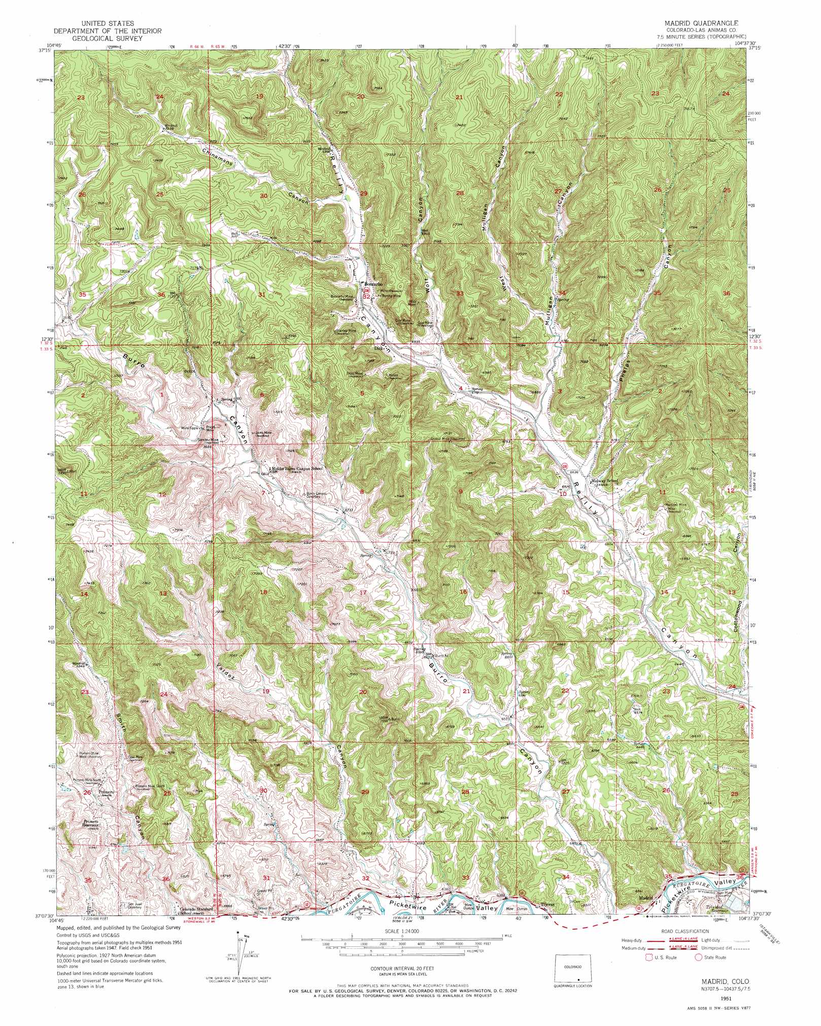
USGS Topo Quad 37104b6 - 1:24,000 scale
| Topo Map Name: | Madrid |
| USGS Topo Quad ID: | 37104b6 |
| Print Size: | ca. 21 1/4" wide x 27" high |
| Southeast Coordinates: | 37.125° N latitude / 104.625° W longitude |
| Map Center Coordinates: | 37.1875° N latitude / 104.6875° W longitude |
| U.S. State: | CO |
| Filename: | o37104b6.jpg |
| Download Map JPG Image: | Madrid topo map 1:24,000 scale |
| Map Type: | Topographic |
| Topo Series: | 7.5´ |
| Map Scale: | 1:24,000 |
| Source of Map Images: | United States Geological Survey (USGS) |
| Alternate Map Versions: |
Madrid CO 1951, updated 1953 Download PDF Buy paper map Madrid CO 1951, updated 1953 Download PDF Buy paper map Madrid CO 1951, updated 1971 Download PDF Buy paper map Madrid CO 2010 Download PDF Buy paper map Madrid CO 2013 Download PDF Buy paper map Madrid CO 2016 Download PDF Buy paper map |
1:24,000 Topo Quads surrounding Madrid
Spanish Peaks |
Santa Clara |
Aguilar |
The Hogback |
Vega Corral |
Herlick Canyon |
Gulnare |
Delagua |
Ludlow |
Hoehne |
Vigil |
Weston |
Madrid |
Trinidad West |
Trinidad East |
Tercio |
Little Pine Canyon |
Valdez |
Starkville |
Fishers Peak |
Casa Grande |
Caliente Canyon North |
Mcwilliams Canyon |
Tin Pan Canyon |
Raton |
> Back to 37104a1 at 1:100,000 scale
> Back to 37104a1 at 1:250,000 scale
> Back to U.S. Topo Maps home
Madrid topo map: Gazetteer
Madrid: Dams
Madrid Dam elevation 1930m 6332′Madrid: Mines
Boncarbo Mine elevation 2113m 6932′Crystal Mine elevation 2149m 7050′
Deer Canyon Mine elevation 2163m 7096′
Dick Coal Mine elevation 2116m 6942′
Dicks Mine elevation 2121m 6958′
Eureka Mine elevation 2135m 7004′
Jacks Mine elevation 2116m 6942′
Joger Mine elevation 1913m 6276′
Joger Mine elevation 1924m 6312′
Martinez Mine elevation 2062m 6765′
Pricco Mine elevation 2109m 6919′
Primero Mine North elevation 2084m 6837′
Primero Mine South elevation 2066m 6778′
Primero Mine West elevation 2092m 6863′
Sanchez Mine elevation 2107m 6912′
Stanley Mine elevation 2120m 6955′
Viola Mine elevation 2128m 6981′
Madrid: Populated Places
Boncarbo elevation 2096m 6876′Primero (historical) elevation 2077m 6814′
Tijeras elevation 1938m 6358′
Madrid: Reservoirs
Madrid Reservoir elevation 1930m 6332′Primero Reservoir elevation 2088m 6850′
Madrid: Valleys
Burro Canyon elevation 1928m 6325′Chinamans Canyon elevation 2120m 6955′
Cottonwood Canyon elevation 1947m 6387′
Madrid Canyon elevation 1916m 6286′
Mulligan Canyon elevation 2031m 6663′
Phelps Canyon elevation 2024m 6640′
Valdez Canyon elevation 1955m 6414′
West Milligan Canyon elevation 2065m 6774′
Wolf Canyon elevation 2069m 6788′
Madrid digital topo map on disk
Buy this Madrid topo map showing relief, roads, GPS coordinates and other geographical features, as a high-resolution digital map file on DVD: