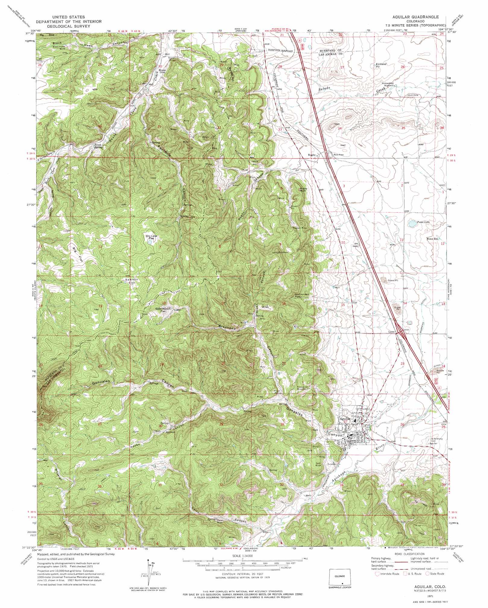
Aguilar Topo Map Colorado
To zoom in, hover over the map of Aguilar
USGS Topo Quad 37104d6 - 1:24,000 scale
| Topo Map Name: | Aguilar |
| USGS Topo Quad ID: | 37104d6 |
| Print Size: | ca. 21 1/4" wide x 27" high |
| Southeast Coordinates: | 37.375° N latitude / 104.625° W longitude |
| Map Center Coordinates: | 37.4375° N latitude / 104.6875° W longitude |
| U.S. State: | CO |
| Filename: | o37104d6.jpg |
| Download Map JPG Image: | Aguilar topo map 1:24,000 scale |
| Map Type: | Topographic |
| Topo Series: | 7.5´ |
| Map Scale: | 1:24,000 |
| Source of Map Images: | United States Geological Survey (USGS) |
| Alternate Map Versions: |
Aguilar CO 1971, updated 1974 Download PDF Buy paper map Aguilar CO 2010 Download PDF Buy paper map Aguilar CO 2013 Download PDF Buy paper map Aguilar CO 2016 Download PDF Buy paper map |
1:24,000 Topo Quads surrounding Aguilar
Black Hills |
Walsenburg North |
Maria Reservoir |
Cucharas Reservoir |
South Rattlesnake Butte |
Ritter Arroyo |
Walsenburg South |
Pryor |
Pryor Se |
Little Dome |
Spanish Peaks |
Santa Clara |
Aguilar |
The Hogback |
Vega Corral |
Herlick Canyon |
Gulnare |
Delagua |
Ludlow |
Hoehne |
Vigil |
Weston |
Madrid |
Trinidad West |
Trinidad East |
> Back to 37104a1 at 1:100,000 scale
> Back to 37104a1 at 1:250,000 scale
> Back to U.S. Topo Maps home
Aguilar topo map: Gazetteer
Aguilar: Canals
Borrego Ditch elevation 1922m 6305′Gonzales Ditch elevation 1949m 6394′
Aguilar: Flats
Big Flat elevation 2148m 7047′Dry Lake Flat elevation 2196m 7204′
Goat Ranch Flat elevation 2191m 7188′
Sawmill Flat elevation 2213m 7260′
Aguilar: Lakes
Poma Lake elevation 1934m 6345′Aguilar: Mines
Black Hawk Mine elevation 2023m 6637′Blazing Rag Mine elevation 1970m 6463′
Broadhead Mine elevation 2035m 6676′
Bunker Hill Number One Mine elevation 2024m 6640′
Daisy Mine elevation 2045m 6709′
Empire Mine elevation 1968m 6456′
Gem Mine elevation 1995m 6545′
Green Canyon Mines elevation 2157m 7076′
Healy Strip Mine elevation 1942m 6371′
Jewel Mine elevation 2036m 6679′
Jolly Pit elevation 1933m 6341′
Kenneth Mine elevation 2043m 6702′
Las Animas Number Nine Mine elevation 2065m 6774′
New Rouse Mine elevation 1991m 6532′
Old Number Three Mine elevation 2078m 6817′
Old Wichita Mine elevation 2059m 6755′
Peerless Mine elevation 1965m 6446′
Prosperity Mine elevation 2071m 6794′
Prosperity Mine Number 2 elevation 2065m 6774′
Rapson Mine elevation 2075m 6807′
Rouse Mine elevation 2002m 6568′
Royal Mine elevation 2093m 6866′
Royal Mine elevation 1995m 6545′
Southwestern Mine elevation 2071m 6794′
Spring Mine elevation 2067m 6781′
Vickers Mine elevation 2016m 6614′
Victor Smith Prospect elevation 2244m 7362′
Weeks Mine elevation 2052m 6732′
Aguilar: Populated Places
Aguilar elevation 1947m 6387′Lynn elevation 1934m 6345′
Rouse elevation 1984m 6509′
Rugby elevation 1974m 6476′
Aguilar: Reservoirs
Kirkland Pit elevation 1939m 6361′Poma Reservoir elevation 1913m 6276′
Aguilar: Springs
Rouse Spring elevation 2007m 6584′Aguilar: Streams
North Santa Clara Creek elevation 2019m 6624′South Santa Clara Creek elevation 2019m 6624′
Aguilar: Summits
Bunker Hill elevation 2081m 6827′Rugby Rock elevation 2061m 6761′
T V Hill elevation 2176m 7139′
Aguilar: Valleys
Adobe Canyon elevation 2039m 6689′Brodhead Canyon elevation 1987m 6519′
Daisy Canyon elevation 1976m 6482′
Fourmile Canyon elevation 1982m 6502′
Gonzales Canyon elevation 1949m 6394′
Green Canyon elevation 2057m 6748′
Rugby Canyon elevation 1990m 6528′
Spring Canyon elevation 2034m 6673′
Aguilar digital topo map on disk
Buy this Aguilar topo map showing relief, roads, GPS coordinates and other geographical features, as a high-resolution digital map file on DVD: