Yellowbank Creek Topo Map Colorado
To zoom in, hover over the map of Yellowbank Creek
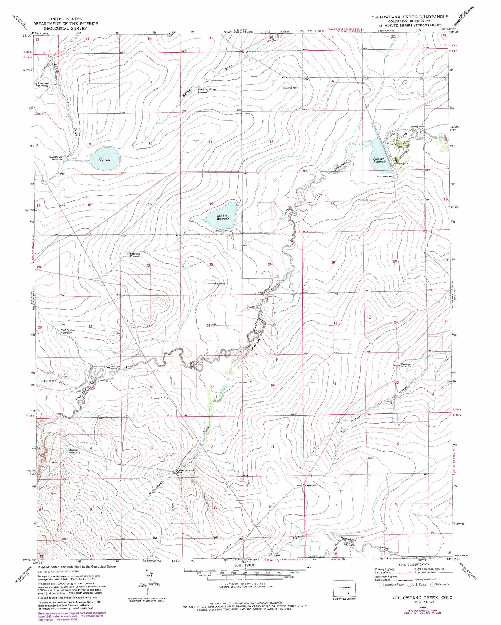
USGS Topo Quad 37104h2 - 1:24,000 scale
| Topo Map Name: | Yellowbank Creek |
| USGS Topo Quad ID: | 37104h2 |
| Print Size: | ca. 21 1/4" wide x 27" high |
| Southeast Coordinates: | 37.875° N latitude / 104.125° W longitude |
| Map Center Coordinates: | 37.9375° N latitude / 104.1875° W longitude |
| U.S. State: | CO |
| Filename: | o37104h2.jpg |
| Download Map JPG Image: | Yellowbank Creek topo map 1:24,000 scale |
| Map Type: | Topographic |
| Topo Series: | 7.5´ |
| Map Scale: | 1:24,000 |
| Source of Map Images: | United States Geological Survey (USGS) |
| Alternate Map Versions: |
Yellowbank Creek CO 1970, updated 1974 Download PDF Buy paper map Yellowbank Creek CO 1970, updated 1974 Download PDF Buy paper map Yellowbank Creek CO 1970, updated 1985 Download PDF Buy paper map Yellowbank Creek CO 1970, updated 1985 Download PDF Buy paper map Yellowbank Creek CO 2010 Download PDF Buy paper map Yellowbank Creek CO 2013 Download PDF Buy paper map Yellowbank Creek CO 2016 Download PDF Buy paper map |
1:24,000 Topo Quads surrounding Yellowbank Creek
Vineland |
Avondale |
Nepesta |
Fowler |
Olney Springs |
Doyle Bridge |
Chicos Well |
Flying A Ranch |
Hardesty Reservoir |
Elder |
Hog Ranch Canyon |
Red Top Ranch |
Yellowbank Creek |
Apishapa Bridge |
Timpas Nw |
North Rattlesnake Butte |
Myers Canyon |
Sanford Hills |
Snowden Lake |
Timpas Sw |
South Rattlesnake Butte |
Jones Lake Spring |
Sun Valley Ranch |
Delhi |
Bloom |
> Back to 37104e1 at 1:100,000 scale
> Back to 37104a1 at 1:250,000 scale
> Back to U.S. Topo Maps home
Yellowbank Creek topo map: Gazetteer
Yellowbank Creek: Cliffs
Yellowbank elevation 1445m 4740′Yellowbank Creek: Dams
Brown Dam elevation 1409m 4622′Red Top Dam elevation 1430m 4691′
Yellowbank Creek: Lakes
Dry Lake elevation 1450m 4757′Yellowbank Creek: Mines
Yellow Banks Dome Pit elevation 1485m 4872′Yellowbank Creek: Reservoirs
Altman Reservoir elevation 1488m 4881′Baldwin Reservoir elevation 1455m 4773′
Big Pit elevation 1470m 4822′
Bombing Range Reservoir elevation 1436m 4711′
Brown Reservoir elevation 1409m 4622′
Bull Pasture Reservoir elevation 1467m 4812′
Red Top Reservoir elevation 1430m 4691′
Schoolhouse Reservoir elevation 1452m 4763′
Stauder Reservoir elevation 1409m 4622′
Yellowbank Creek: Streams
Peterson Creek elevation 1468m 4816′Yellowbank Creek elevation 1436m 4711′
Yellowbank Creek: Wells
Evans Well elevation 1441m 4727′Yellowbank Creek digital topo map on disk
Buy this Yellowbank Creek topo map showing relief, roads, GPS coordinates and other geographical features, as a high-resolution digital map file on DVD: