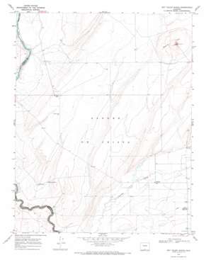
Sky Valley Ranch Topo Map Colorado
To zoom in, hover over the map of Sky Valley Ranch
USGS Topo Quad 37105a6 - 1:24,000 scale
| Topo Map Name: | Sky Valley Ranch |
| USGS Topo Quad ID: | 37105a6 |
| Print Size: | ca. 21 1/4" wide x 27" high |
| Southeast Coordinates: | 37° N latitude / 105.625° W longitude |
| Map Center Coordinates: | 37.0625° N latitude / 105.6875° W longitude |
| U.S. State: | CO |
| Filename: | o37105a6.jpg |
| Download Map JPG Image: | Sky Valley Ranch topo map 1:24,000 scale |
| Map Type: | Topographic |
| Topo Series: | 7.5´ |
| Map Scale: | 1:24,000 |
| Source of Map Images: | United States Geological Survey (USGS) |
| Alternate Map Versions: |
Sky Valley Ranch CO 1967, updated 1971 Download PDF Buy paper map Sky Valley Ranch CO 2010 Download PDF Buy paper map Sky Valley Ranch CO 2013 Download PDF Buy paper map Sky Valley Ranch CO 2016 Download PDF Buy paper map |
1:24,000 Topo Quads surrounding Sky Valley Ranch
> Back to 37105a1 at 1:100,000 scale
> Back to 37104a1 at 1:250,000 scale
> Back to U.S. Topo Maps home
Sky Valley Ranch topo map: Gazetteer
Sky Valley Ranch: Mines
Jake and Hank Mine elevation 2371m 7778′Sky Valley Ranch: Populated Places
Eastdale elevation 2296m 7532′Sky Valley Ranch: Reservoirs
Anderson Reservoir elevation 2313m 7588′Garcia Tank elevation 2301m 7549′
Sky Valley Ranch: Summits
Mesita Hill elevation 2375m 7791′Sky Valley Ranch: Wells
Craven Well elevation 2305m 7562′Sharbert Well elevation 2324m 7624′
Sky Valley Ranch digital topo map on disk
Buy this Sky Valley Ranch topo map showing relief, roads, GPS coordinates and other geographical features, as a high-resolution digital map file on DVD:


