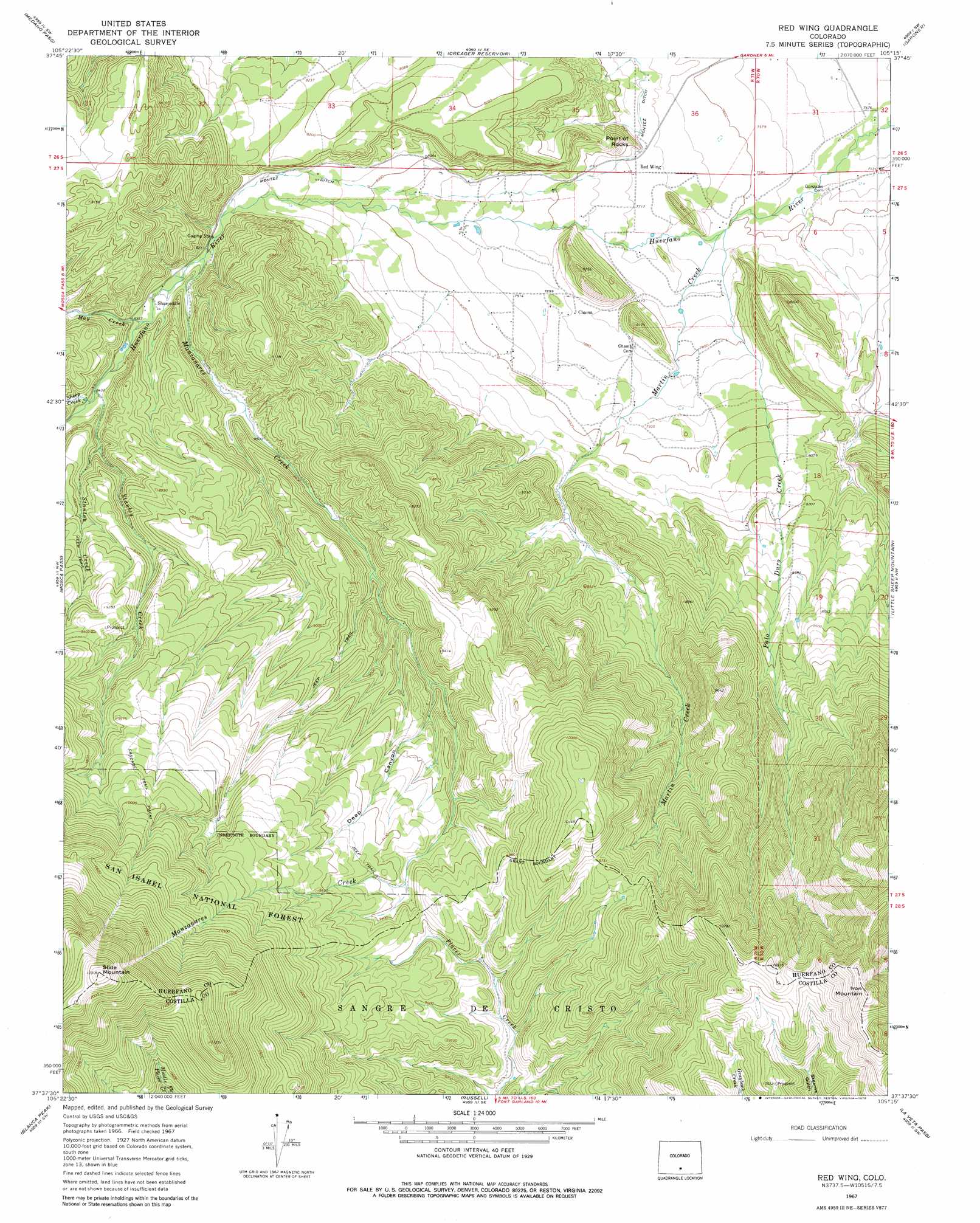
Red Wing Topo Map Colorado
To zoom in, hover over the map of Red Wing
USGS Topo Quad 37105f3 - 1:24,000 scale
| Topo Map Name: | Red Wing |
| USGS Topo Quad ID: | 37105f3 |
| Print Size: | ca. 21 1/4" wide x 27" high |
| Southeast Coordinates: | 37.625° N latitude / 105.25° W longitude |
| Map Center Coordinates: | 37.6875° N latitude / 105.3125° W longitude |
| U.S. State: | CO |
| Filename: | o37105f3.jpg |
| Download Map JPG Image: | Red Wing topo map 1:24,000 scale |
| Map Type: | Topographic |
| Topo Series: | 7.5´ |
| Map Scale: | 1:24,000 |
| Source of Map Images: | United States Geological Survey (USGS) |
| Alternate Map Versions: |
Red Wing CO 1967, updated 1972 Download PDF Buy paper map Red Wing CO 1967, updated 1972 Download PDF Buy paper map Red Wing CO 1967, updated 1978 Download PDF Buy paper map Red Wing CO 2001, updated 2005 Download PDF Buy paper map Red Wing CO 2011 Download PDF Buy paper map Red Wing CO 2013 Download PDF Buy paper map Red Wing CO 2016 Download PDF Buy paper map |
| FStopo: | US Forest Service topo Red Wing is available: Download FStopo PDF Download FStopo TIF |
1:24,000 Topo Quads surrounding Red Wing
Crestone Peak |
Beck Mountain |
Devils Gulch |
Bear Creek |
San Isabel |
Liberty |
Medano Pass |
Creager Reservoir |
Gardner |
Badito Cone |
Zapata Ranch |
Mosca Pass |
Red Wing |
Little Sheep Mountain |
Farisita |
Twin Peaks |
Blanca Peak |
Russell |
La Veta Pass |
La Veta |
Blanca |
Fort Garland |
Trinchera Ranch |
Mccarty Park |
Cuchara |
> Back to 37105e1 at 1:100,000 scale
> Back to 37104a1 at 1:250,000 scale
> Back to U.S. Topo Maps home
Red Wing topo map: Gazetteer
Red Wing: Canals
Montez Ditch elevation 2380m 7808′Red Wing: Dams
McIntire Dam elevation 2381m 7811′Pala Dura Dam elevation 2558m 8392′
Red Wing: Mines
Copper King Mine elevation 3121m 10239′McIntire Mine elevation 2567m 8421′
Santa Rosa Mine elevation 2453m 8047′
Red Wing: Populated Places
Chama elevation 2402m 7880′Red Wing elevation 2355m 7726′
Red Wing: Reservoirs
McIntire Reservoir elevation 2381m 7811′Pala Dura Reservoir elevation 2558m 8392′
Red Wing: Streams
Manzanares Creek elevation 2503m 8211′Martin Creek elevation 2323m 7621′
May Creek elevation 2536m 8320′
Palo Duro Creek elevation 2320m 7611′
Sheep Creek elevation 2573m 8441′
Stanley Creek elevation 2570m 8431′
Stanton Creek elevation 2605m 8546′
Red Wing: Summits
Iron Mountain elevation 3479m 11414′Point of Rocks elevation 2464m 8083′
Slide Mountain elevation 3750m 12303′
Red Wing: Trails
Cascade Trail elevation 3215m 10547′Red Wing: Valleys
Deep Canyon elevation 2754m 9035′Red Wing digital topo map on disk
Buy this Red Wing topo map showing relief, roads, GPS coordinates and other geographical features, as a high-resolution digital map file on DVD: