Red Mountain Topo Map Colorado
To zoom in, hover over the map of Red Mountain
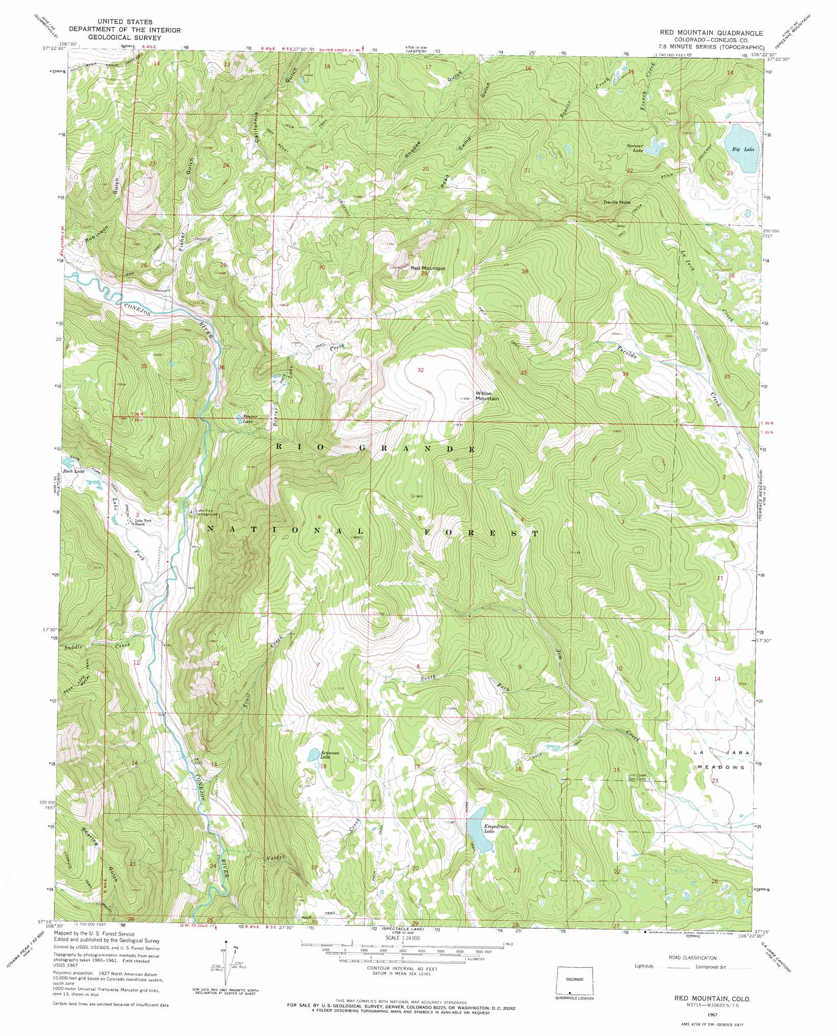
USGS Topo Quad 37106c4 - 1:24,000 scale
| Topo Map Name: | Red Mountain |
| USGS Topo Quad ID: | 37106c4 |
| Print Size: | ca. 21 1/4" wide x 27" high |
| Southeast Coordinates: | 37.25° N latitude / 106.375° W longitude |
| Map Center Coordinates: | 37.3125° N latitude / 106.4375° W longitude |
| U.S. State: | CO |
| Filename: | o37106c4.jpg |
| Download Map JPG Image: | Red Mountain topo map 1:24,000 scale |
| Map Type: | Topographic |
| Topo Series: | 7.5´ |
| Map Scale: | 1:24,000 |
| Source of Map Images: | United States Geological Survey (USGS) |
| Alternate Map Versions: |
Red Mountain CO 1967, updated 1969 Download PDF Buy paper map Red Mountain CO 1967, updated 1969 Download PDF Buy paper map Red Mountain CO 1967, updated 1969 Download PDF Buy paper map Red Mountain CO 2001, updated 2005 Download PDF Buy paper map Red Mountain CO 2011 Download PDF Buy paper map Red Mountain CO 2013 Download PDF Buy paper map Red Mountain CO 2016 Download PDF Buy paper map |
| FStopo: | US Forest Service topo Red Mountain is available: Download FStopo PDF Download FStopo TIF |
1:24,000 Topo Quads surrounding Red Mountain
Beaver Creek Reservoir |
Del Norte Peak |
Horseshoe Mountain |
Dog Mountain |
Monte Vista |
Elwood Pass |
Summitville |
Jasper |
Greenie Mountain |
Fulcher Gulch |
Summit Peak |
Platoro |
Red Mountain |
Terrace Reservoir |
Centro |
Elephant Head Rock |
Victoria Lake |
Spectacle Lake |
La Jara Canyon |
Vicente Canyon |
Chama Peak |
Archuleta Creek |
Cumbres |
Osier |
Fox Creek |
> Back to 37106a1 at 1:100,000 scale
> Back to 37106a1 at 1:250,000 scale
> Back to U.S. Topo Maps home
Red Mountain topo map: Gazetteer
Red Mountain: Basins
Devils Hole elevation 3071m 10075′Red Mountain: Canals
Johns Ditch elevation 3159m 10364′Red Mountain: Flats
La Jara Meadows elevation 2981m 9780′Red Mountain: Lakes
Acascosa Lake elevation 3348m 10984′Beaver Lake elevation 3005m 9858′
Big Lake elevation 3067m 10062′
Empedrado Lake elevation 3311m 10862′
Rock Lake elevation 2933m 9622′
Spencer Lake elevation 2994m 9822′
Red Mountain: Mines
Congress Mine elevation 3093m 10147′Red Mountain: Streams
Beaver Lake Creek elevation 2916m 9566′Lake Fork elevation 2861m 9386′
Saddle Creek elevation 2849m 9347′
South Fork Jim Creek elevation 3100m 10170′
Trail Creek elevation 2821m 9255′
Valdez Creek elevation 2797m 9176′
Red Mountain: Summits
Red Mountain elevation 3550m 11646′Willow Mountain elevation 3626m 11896′
Red Mountain: Trails
Hot Creek Stock Driveway elevation 3379m 11085′Red Mountain: Valleys
Fisher Gulch elevation 2991m 9812′Road Camp Gulch elevation 2983m 9786′
Robinson Gulch elevation 2986m 9796′
Red Mountain digital topo map on disk
Buy this Red Mountain topo map showing relief, roads, GPS coordinates and other geographical features, as a high-resolution digital map file on DVD: