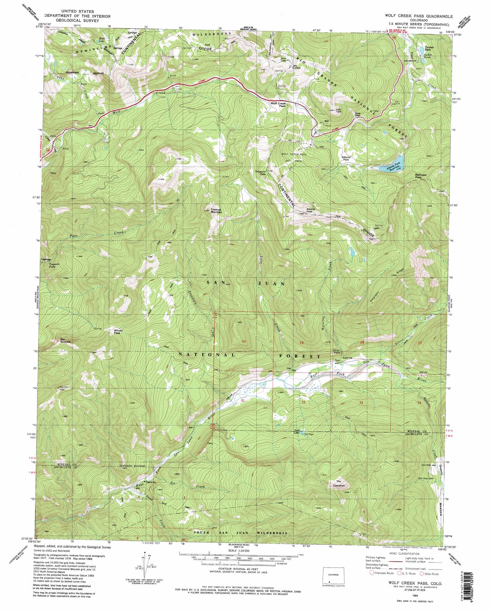
Wolf Creek Pass Topo Map Colorado
To zoom in, hover over the map of Wolf Creek Pass
USGS Topo Quad 37106d7 - 1:24,000 scale
| Topo Map Name: | Wolf Creek Pass |
| USGS Topo Quad ID: | 37106d7 |
| Print Size: | ca. 21 1/4" wide x 27" high |
| Southeast Coordinates: | 37.375° N latitude / 106.75° W longitude |
| Map Center Coordinates: | 37.4375° N latitude / 106.8125° W longitude |
| U.S. State: | CO |
| Filename: | o37106d7.jpg |
| Download Map JPG Image: | Wolf Creek Pass topo map 1:24,000 scale |
| Map Type: | Topographic |
| Topo Series: | 7.5´ |
| Map Scale: | 1:24,000 |
| Source of Map Images: | United States Geological Survey (USGS) |
| Alternate Map Versions: |
Wolf Creek Pass CO 1984, updated 1984 Download PDF Buy paper map Wolf Creek Pass CO 1984, updated 1984 Download PDF Buy paper map Wolf Creek Pass CO 1984, updated 1984 Download PDF Buy paper map Wolf Creek Pass CO 2011 Download PDF Buy paper map Wolf Creek Pass CO 2013 Download PDF Buy paper map Wolf Creek Pass CO 2016 Download PDF Buy paper map |
| FStopo: | US Forest Service topo Wolf Creek Pass is available: Download FStopo PDF Download FStopo TIF |
1:24,000 Topo Quads surrounding Wolf Creek Pass
Workman Creek |
Spar City |
Lake Humphreys |
South Fork West |
South Fork East |
Palomino Mountain |
South River Creek |
Mount Hope |
Beaver Creek Reservoir |
Del Norte Peak |
Pagosa Peak |
Saddle Mountain |
Wolf Creek Pass |
Elwood Pass |
Summitville |
Pagosa Springs |
Jackson Mountain |
Blackhead Peak |
Summit Peak |
Platoro |
Oakbrush Hill |
Serviceberry Mountain |
Harris Lake |
Elephant Head Rock |
Victoria Lake |
> Back to 37106a1 at 1:100,000 scale
> Back to 37106a1 at 1:250,000 scale
> Back to U.S. Topo Maps home
Wolf Creek Pass topo map: Gazetteer
Wolf Creek Pass: Canals
Lake Creek elevation 2935m 9629′Wolf Creek Pass: Dams
Alberta Park Dam elevation 3106m 10190′Wolf Creek Pass: Falls
Treasure Falls elevation 2603m 8540′Wolf Creek Pass: Flats
Alberta Park elevation 3149m 10331′Tucker Park elevation 2962m 9717′
Wolf Creek Pass: Gaps
Windy Pass elevation 3035m 9957′Wolf Creek Pass elevation 3299m 10823′
Wolf Creek Pass: Lakes
Rock Lake elevation 3461m 11354′Wolf Creek Pass: Ranges
San Juan Mountains elevation 3250m 10662′Wolf Creek Pass: Reservoirs
Alberta Park Reservoir elevation 3106m 10190′Wolf Creek Pass: Streams
Alamosa River elevation 2599m 8526′Camp Creek elevation 2770m 9087′
Lake Creek elevation 2941m 9648′
Lane Creek elevation 2470m 8103′
Quartz Creek elevation 2511m 8238′
Sand Creek elevation 2417m 7929′
Silver Creek elevation 2498m 8195′
Tie Creek elevation 2428m 7965′
Treasure Creek elevation 2458m 8064′
Waterfall Creek elevation 2472m 8110′
Wolf Creek Pass: Summits
Alberta Peak elevation 3613m 11853′Treasure Mountain elevation 3613m 11853′
Wolf Creek Pass: Trails
Treasure Mountain Trail elevation 3035m 9957′Windy Pass Trail elevation 2780m 9120′
Wolf Creek Pass digital topo map on disk
Buy this Wolf Creek Pass topo map showing relief, roads, GPS coordinates and other geographical features, as a high-resolution digital map file on DVD: