Lake Humphreys Topo Map Colorado
To zoom in, hover over the map of Lake Humphreys
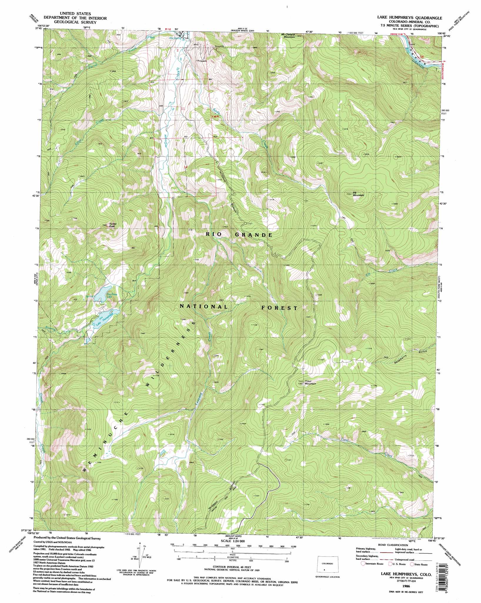
USGS Topo Quad 37106f7 - 1:24,000 scale
| Topo Map Name: | Lake Humphreys |
| USGS Topo Quad ID: | 37106f7 |
| Print Size: | ca. 21 1/4" wide x 27" high |
| Southeast Coordinates: | 37.625° N latitude / 106.75° W longitude |
| Map Center Coordinates: | 37.6875° N latitude / 106.8125° W longitude |
| U.S. State: | CO |
| Filename: | o37106f7.jpg |
| Download Map JPG Image: | Lake Humphreys topo map 1:24,000 scale |
| Map Type: | Topographic |
| Topo Series: | 7.5´ |
| Map Scale: | 1:24,000 |
| Source of Map Images: | United States Geological Survey (USGS) |
| Alternate Map Versions: |
Lake Humphreys CO 1986, updated 1986 Download PDF Buy paper map Lake Humphreys CO 1986, updated 1986 Download PDF Buy paper map Lake Humphreys CO 2001, updated 2005 Download PDF Buy paper map Lake Humphreys CO 2011 Download PDF Buy paper map Lake Humphreys CO 2013 Download PDF Buy paper map Lake Humphreys CO 2016 Download PDF Buy paper map |
| FStopo: | US Forest Service topo Lake Humphreys is available: Download FStopo PDF Download FStopo TIF |
1:24,000 Topo Quads surrounding Lake Humphreys
Baldy Cinco |
San Luis Peak |
Halfmoon Pass |
Mesa Mountain |
Bowers Peak |
Bristol Head |
Creede |
Wagon Wheel Gap |
Pool Table Mountain |
Pine Cone Knob |
Workman Creek |
Spar City |
Lake Humphreys |
South Fork West |
South Fork East |
Palomino Mountain |
South River Creek |
Mount Hope |
Beaver Creek Reservoir |
Del Norte Peak |
Pagosa Peak |
Saddle Mountain |
Wolf Creek Pass |
Elwood Pass |
Summitville |
> Back to 37106e1 at 1:100,000 scale
> Back to 37106a1 at 1:250,000 scale
> Back to U.S. Topo Maps home
Lake Humphreys topo map: Gazetteer
Lake Humphreys: Dams
Hay Press Park Dam elevation 2776m 9107′Humphreys Dam elevation 2739m 8986′
Lake Humphreys: Reservoirs
Hay Press Lake elevation 2776m 9107′Lake Humphreys elevation 2739m 8986′
Lake Humphreys: Springs
Wagon Wheel Gap Hot Springs elevation 2592m 8503′Wagon Wheel Springs elevation 3113m 10213′
Lake Humphreys: Streams
Brush Creek elevation 3345m 10974′Elliot Creek elevation 2616m 8582′
Fisher Creek elevation 2801m 9189′
Leopard Creek elevation 2633m 8638′
Pierce Creek elevation 2593m 8507′
Roaring Fork elevation 2742m 8996′
Soda Creek elevation 2594m 8510′
Lake Humphreys: Summits
Elk Mountain elevation 3383m 11099′McClelland Mountain elevation 3316m 10879′
Trout Mountain elevation 3638m 11935′
Turret Peak elevation 3244m 10643′
Lake Humphreys digital topo map on disk
Buy this Lake Humphreys topo map showing relief, roads, GPS coordinates and other geographical features, as a high-resolution digital map file on DVD: