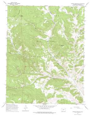
Lookout Mountain Topo Map Colorado
To zoom in, hover over the map of Lookout Mountain
USGS Topo Quad 37106h4 - 1:24,000 scale
| Topo Map Name: | Lookout Mountain |
| USGS Topo Quad ID: | 37106h4 |
| Print Size: | ca. 21 1/4" wide x 27" high |
| Southeast Coordinates: | 37.875° N latitude / 106.375° W longitude |
| Map Center Coordinates: | 37.9375° N latitude / 106.4375° W longitude |
| U.S. State: | CO |
| Filename: | o37106h4.jpg |
| Download Map JPG Image: | Lookout Mountain topo map 1:24,000 scale |
| Map Type: | Topographic |
| Topo Series: | 7.5´ |
| Map Scale: | 1:24,000 |
| Source of Map Images: | United States Geological Survey (USGS) |
| Alternate Map Versions: |
Lookout Mountain CO 1967, updated 1969 Download PDF Buy paper map Lookout Mountain CO 1967, updated 1969 Download PDF Buy paper map Lookout Mountain CO 1967, updated 1975 Download PDF Buy paper map Lookout Mountain CO 2001, updated 2005 Download PDF Buy paper map Lookout Mountain CO 2011 Download PDF Buy paper map Lookout Mountain CO 2013 Download PDF Buy paper map Lookout Mountain CO 2016 Download PDF Buy paper map |
| FStopo: | US Forest Service topo Lookout Mountain is available: Download FStopo PDF Download FStopo TIF |
1:24,000 Topo Quads surrounding Lookout Mountain
> Back to 37106e1 at 1:100,000 scale
> Back to 37106a1 at 1:250,000 scale
> Back to U.S. Topo Maps home
Lookout Mountain topo map: Gazetteer
Lookout Mountain: Dams
Paradise Dam elevation 2770m 9087′Lookout Mountain: Flats
Mexican Park elevation 3013m 9885′Royal Park elevation 2954m 9691′
Sunnyside Park elevation 3157m 10357′
Lookout Mountain: Reservoirs
Paradise Reservoir elevation 2770m 9087′Lookout Mountain: Streams
Cave Creek elevation 2717m 8914′Cecilia Creek elevation 2839m 9314′
Deer Creek elevation 2988m 9803′
Fence Creek elevation 2784m 9133′
Lost Cabin Creek elevation 2853m 9360′
Mann Creek elevation 2805m 9202′
Masauernez Creek elevation 2896m 9501′
Middle Fork Carnero Creek elevation 2627m 8618′
North Fork Carnero Creek elevation 2621m 8599′
Oso Creek elevation 2744m 9002′
Poso Creek elevation 2695m 8841′
Prong Creek elevation 2975m 9760′
Sawlog Creek elevation 2706m 8877′
South Fork Carnero Creek elevation 2627m 8618′
Lookout Mountain: Summits
Lookout Mountain elevation 3501m 11486′Storm King Mountain elevation 3307m 10849′
Lookout Mountain: Trails
Laughlin Stock Driveway elevation 3169m 10396′Lime Creek Stock Driveway elevation 2769m 9084′
Lookout Mountain: Valleys
Bull Gulch elevation 2703m 8868′Dry Gulch elevation 2622m 8602′
Poison Gulch elevation 2824m 9265′
Raspberry Gulch elevation 2917m 9570′
Royal Gulch elevation 2767m 9078′
Lookout Mountain digital topo map on disk
Buy this Lookout Mountain topo map showing relief, roads, GPS coordinates and other geographical features, as a high-resolution digital map file on DVD:


