San Luis Peak Topo Map Colorado
To zoom in, hover over the map of San Luis Peak
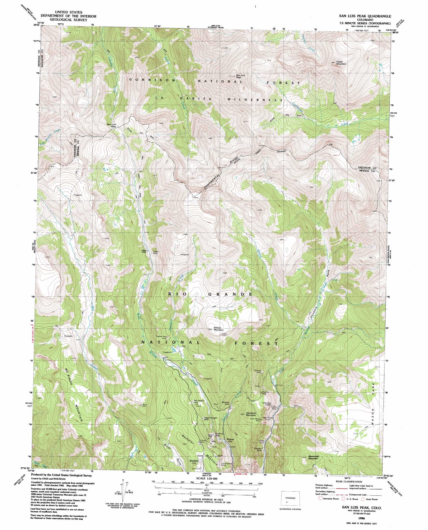
USGS Topo Quad 37106h8 - 1:24,000 scale
| Topo Map Name: | San Luis Peak |
| USGS Topo Quad ID: | 37106h8 |
| Print Size: | ca. 21 1/4" wide x 27" high |
| Southeast Coordinates: | 37.875° N latitude / 106.875° W longitude |
| Map Center Coordinates: | 37.9375° N latitude / 106.9375° W longitude |
| U.S. State: | CO |
| Filename: | o37106h8.jpg |
| Download Map JPG Image: | San Luis Peak topo map 1:24,000 scale |
| Map Type: | Topographic |
| Topo Series: | 7.5´ |
| Map Scale: | 1:24,000 |
| Source of Map Images: | United States Geological Survey (USGS) |
| Alternate Map Versions: |
San Luis Peak CO 1986, updated 1986 Download PDF Buy paper map San Luis Peak CO 2001, updated 2005 Download PDF Buy paper map San Luis Peak CO 2011 Download PDF Buy paper map San Luis Peak CO 2013 Download PDF Buy paper map San Luis Peak CO 2016 Download PDF Buy paper map |
| FStopo: | US Forest Service topo San Luis Peak is available: Download FStopo PDF Download FStopo TIF |
1:24,000 Topo Quads surrounding San Luis Peak
Powderhorn Lakes |
Rudolph Hill |
Rock Creek Park |
Cold Spring Park |
Cochetopa Park |
Cannibal Plateau |
Mineral Mountain |
Stewart Peak |
Elk Park |
Saguache Park |
Slumgullion Pass |
Baldy Cinco |
San Luis Peak |
Halfmoon Pass |
Mesa Mountain |
Hermit Lakes |
Bristol Head |
Creede |
Wagon Wheel Gap |
Pool Table Mountain |
Little Squaw Creek |
Workman Creek |
Spar City |
Lake Humphreys |
South Fork West |
> Back to 37106e1 at 1:100,000 scale
> Back to 37106a1 at 1:250,000 scale
> Back to U.S. Topo Maps home
San Luis Peak topo map: Gazetteer
San Luis Peak: Flats
Phoenix Park elevation 3197m 10488′San Luis Peak: Gaps
San Luis Pass elevation 3636m 11929′San Luis Peak: Lakes
Beaver Ponds elevation 3577m 11735′San Luis Peak: Mines
Amethyst Mine elevation 3026m 9927′Bachelor Mine elevation 3242m 10636′
Berkshire Shaft Mine elevation 3250m 10662′
Captive Inca Mine elevation 3374m 11069′
Chance Number Two Mine elevation 3053m 10016′
Cliff Shaft Mine elevation 2939m 9642′
Cowboy Johnson Adit Mine elevation 3468m 11377′
Equinox Mine elevation 3042m 9980′
Equity Mine elevation 3389m 11118′
Ethel Shaft Mine elevation 3024m 9921′
Frazee Mine elevation 3226m 10583′
Gateway Adit Mine elevation 3147m 10324′
Gorma Mine elevation 3154m 10347′
Granite Mine elevation 3226m 10583′
Happy Thought Mine elevation 3141m 10305′
Holy Moses Mine elevation 3078m 10098′
Homestead Number One Mine elevation 3042m 9980′
Humphreys Tunnel Mine elevation 3042m 9980′
Kanawha Mine elevation 3226m 10583′
Last Chance Mine elevation 3155m 10351′
Mary Anderson Mine elevation 3416m 11207′
Mexico Mine elevation 3076m 10091′
Midwest Mine elevation 3153m 10344′
Outlet Mine elevation 2968m 9737′
Palo Alto Tunnel Mine elevation 3128m 10262′
Park Regent Mine elevation 3210m 10531′
Phoenix Mine elevation 3185m 10449′
Pittsburgh Mine elevation 3252m 10669′
Resurrection Tunnel Mine elevation 3437m 11276′
Ridge Mine elevation 2905m 9530′
River View Tunnel Mine elevation 3226m 10583′
Robinson Mine elevation 3042m 9980′
Runaround Mine elevation 3226m 10583′
Silver King Mine elevation 3461m 11354′
Sloan Tunnel Mine elevation 3182m 10439′
Solomon Mine elevation 2892m 9488′
Solomon Mine elevation 2890m 9481′
Texas Girl Mine elevation 3042m 9980′
United Mines Shaft elevation 3235m 10613′
White Star Mine elevation 3287m 10784′
Wooster Mine elevation 3182m 10439′
San Luis Peak: Populated Places
Weaver (historical) elevation 3006m 9862′San Luis Peak: Streams
Deerhorn Creek elevation 3168m 10393′Nelson Creek elevation 2992m 9816′
Werner Arroyo elevation 3587m 11768′
Whited Creek elevation 3107m 10193′
San Luis Peak: Summits
Bachelor Mountain elevation 3308m 10853′Campbell Mountain elevation 3321m 10895′
Mammoth Mountain elevation 3552m 11653′
McKenzie Mountain elevation 3578m 11738′
Nelson Mountain elevation 3688m 12099′
Organ Mountain elevation 4185m 13730′
San Luis Peak elevation 4268m 14002′
San Luis Peak: Trails
La Garita Stock Driveway elevation 3370m 11056′Skyline Trail elevation 3730m 12237′
Wason Stock Driveway elevation 3474m 11397′
San Luis Peak digital topo map on disk
Buy this San Luis Peak topo map showing relief, roads, GPS coordinates and other geographical features, as a high-resolution digital map file on DVD: