Bayfield Topo Map Colorado
To zoom in, hover over the map of Bayfield
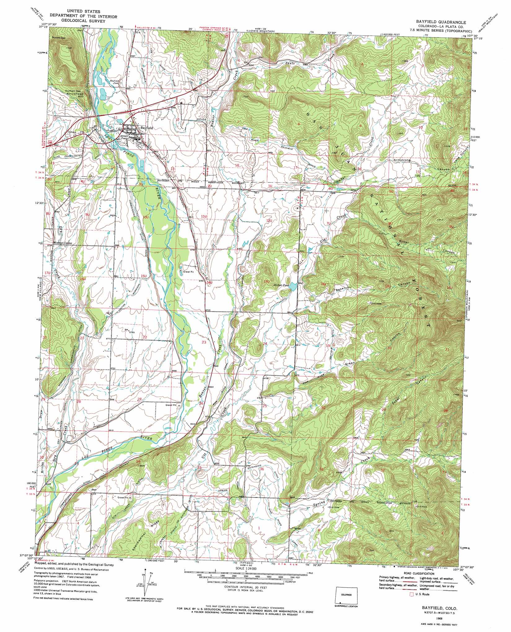
USGS Topo Quad 37107b5 - 1:24,000 scale
| Topo Map Name: | Bayfield |
| USGS Topo Quad ID: | 37107b5 |
| Print Size: | ca. 21 1/4" wide x 27" high |
| Southeast Coordinates: | 37.125° N latitude / 107.5° W longitude |
| Map Center Coordinates: | 37.1875° N latitude / 107.5625° W longitude |
| U.S. State: | CO |
| Filename: | o37107b5.jpg |
| Download Map JPG Image: | Bayfield topo map 1:24,000 scale |
| Map Type: | Topographic |
| Topo Series: | 7.5´ |
| Map Scale: | 1:24,000 |
| Source of Map Images: | United States Geological Survey (USGS) |
| Alternate Map Versions: |
Bayfield CO 1968, updated 1972 Download PDF Buy paper map Bayfield CO 2011 Download PDF Buy paper map Bayfield CO 2013 Download PDF Buy paper map Bayfield CO 2016 Download PDF Buy paper map |
| FStopo: | US Forest Service topo Bayfield is available: Download FStopo PDF Download FStopo TIF |
1:24,000 Topo Quads surrounding Bayfield
Hermosa |
Lemon Reservoir |
Vallecito Reservoir |
Granite Peak |
Bear Mountain |
Durango East |
Rules Hill |
Ludwig Mountain |
Baldy Mountain |
Devil Mountain |
Loma Linda |
Gem Village |
Bayfield |
Pargin Mountain |
Chimney Rock |
Bondad Hill |
Ignacio |
Tiffany |
Allison |
Carracas |
Tank Mountain |
Anastacio Spring |
Burnt Mesa |
Bancos Mesa Nw |
Bancos Mesa |
> Back to 37107a1 at 1:100,000 scale
> Back to 37106a1 at 1:250,000 scale
> Back to U.S. Topo Maps home
Bayfield topo map: Gazetteer
Bayfield: Canals
Ceanoboo Ditch elevation 2069m 6788′Commissioner Ditch elevation 1990m 6528′
Dry Creek Ditch elevation 2019m 6624′
Pine River Bayfield Ditch elevation 2106m 6909′
Schroeder Ditch elevation 2133m 6998′
Spring Creek Extension Ditch elevation 2037m 6683′
Thompson Epperson Ditch elevation 2142m 7027′
Ute Creek Lateral elevation 2038m 6686′
Bayfield: Dams
Reservoir Number 2 Dam elevation 2114m 6935′Bayfield: Gaps
Dunham Gap elevation 2163m 7096′Durant Gap elevation 2234m 7329′
Bayfield: Mines
Marcy-Shenandoah Mine elevation 2098m 6883′Silver Reef Group Mine elevation 2098m 6883′
Bayfield: Populated Places
Bayfield elevation 2103m 6899′Bayfield: Reservoirs
Harper Pond elevation 2087m 6847′Reservoir Number 2 elevation 2114m 6935′
Bayfield: Streams
Beaver Creek elevation 1999m 6558′Crowbar Creek elevation 2073m 6801′
Dry Creek elevation 1986m 6515′
Sauls Creek elevation 2118m 6948′
Bayfield: Summits
Arrowhead Hill elevation 2191m 7188′Bayfield: Valleys
Armstrong Canyon elevation 2130m 6988′Brinks Draw elevation 1994m 6541′
Green Canyon elevation 2056m 6745′
Long Canyon elevation 2197m 7208′
Reservoir Canyon elevation 2066m 6778′
Ritter Canyon elevation 2130m 6988′
Trail Canyon elevation 2219m 7280′
Zabel Canyon elevation 2084m 6837′
Bayfield digital topo map on disk
Buy this Bayfield topo map showing relief, roads, GPS coordinates and other geographical features, as a high-resolution digital map file on DVD: