Engineer Mountain Topo Map Colorado
To zoom in, hover over the map of Engineer Mountain
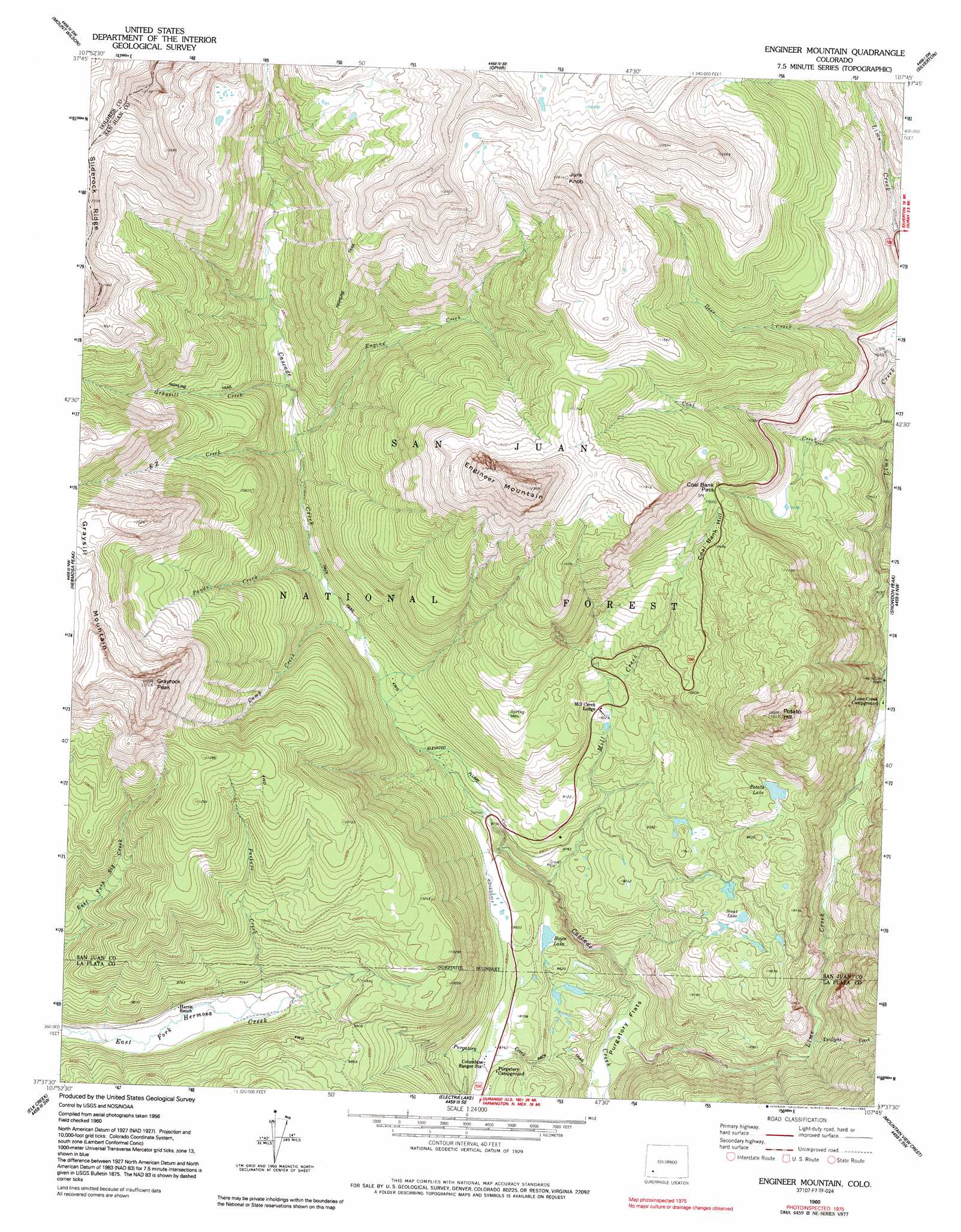
USGS Topo Quad 37107f7 - 1:24,000 scale
| Topo Map Name: | Engineer Mountain |
| USGS Topo Quad ID: | 37107f7 |
| Print Size: | ca. 21 1/4" wide x 27" high |
| Southeast Coordinates: | 37.625° N latitude / 107.75° W longitude |
| Map Center Coordinates: | 37.6875° N latitude / 107.8125° W longitude |
| U.S. State: | CO |
| Filename: | o37107f7.jpg |
| Download Map JPG Image: | Engineer Mountain topo map 1:24,000 scale |
| Map Type: | Topographic |
| Topo Series: | 7.5´ |
| Map Scale: | 1:24,000 |
| Source of Map Images: | United States Geological Survey (USGS) |
| Alternate Map Versions: |
Engineer Mountain CO 1960, updated 1962 Download PDF Buy paper map Engineer Mountain CO 1960, updated 1962 Download PDF Buy paper map Engineer Mountain CO 1960, updated 1968 Download PDF Buy paper map Engineer Mountain CO 1960, updated 1974 Download PDF Buy paper map Engineer Mountain CO 1960, updated 1985 Download PDF Buy paper map Engineer Mountain CO 1960, updated 1992 Download PDF Buy paper map Engineer Mountain CO 2011 Download PDF Buy paper map Engineer Mountain CO 2013 Download PDF Buy paper map Engineer Mountain CO 2016 Download PDF Buy paper map |
| FStopo: | US Forest Service topo Engineer Mountain is available: Download FStopo PDF Download FStopo TIF |
1:24,000 Topo Quads surrounding Engineer Mountain
Little Cone |
Gray Head |
Telluride |
Ironton |
Handies Peak |
Dolores Peak |
Mount Wilson |
Ophir |
Silverton |
Howardsville |
Rico |
Hermosa Peak |
Engineer Mountain |
Snowdon Peak |
Storm King Peak |
Orphan Butte |
Elk Creek |
Electra Lake |
Mountain View Crest |
Columbine Pass |
La Plata |
Monument Hill |
Hermosa |
Lemon Reservoir |
Vallecito Reservoir |
> Back to 37107e1 at 1:100,000 scale
> Back to 37106a1 at 1:250,000 scale
> Back to U.S. Topo Maps home
Engineer Mountain topo map: Gazetteer
Engineer Mountain: Airports
Coal Bank Pass Heliport elevation 3368m 11049′Purgatory Number One Heliport elevation 2667m 8750′
Engineer Mountain: Flats
Purgatory Flat elevation 2454m 8051′Engineer Mountain: Forests
San Juan National Forest elevation 3472m 11391′Engineer Mountain: Gaps
Coal Bank Pass elevation 3234m 10610′Engineer Mountain: Lakes
Potato Lake elevation 2986m 9796′Scout Lake elevation 2849m 9347′
Engineer Mountain: Mines
Sarah G Mine elevation 2693m 8835′Engineer Mountain: Reservoirs
Boyce Lake elevation 2647m 8684′Engineer Mountain: Streams
Camp Creek elevation 2787m 9143′Coal Creek elevation 2867m 9406′
Crater Creek elevation 2812m 9225′
Deer Creek elevation 2929m 9609′
E Z Creek elevation 2874m 9429′
Engine Creek elevation 2888m 9475′
Graysill Creek elevation 2923m 9589′
Lime Creek elevation 2464m 8083′
Mill Creek elevation 2604m 8543′
North Lime Creek elevation 3007m 9865′
Pando Creek elevation 2813m 9229′
Pasture Creek elevation 2849m 9347′
Three Lakes Creek elevation 2835m 9301′
Twilight Creek elevation 2629m 8625′
Engineer Mountain: Summits
Coal Bank Hill elevation 3222m 10570′Engineer Mountain elevation 3940m 12926′
Grayrock Peak elevation 3811m 12503′
Jura Knob elevation 3846m 12618′
Potato Hill elevation 3612m 11850′
Engineer Mountain: Trails
Highline Trail elevation 3749m 12299′Engineer Mountain digital topo map on disk
Buy this Engineer Mountain topo map showing relief, roads, GPS coordinates and other geographical features, as a high-resolution digital map file on DVD: