Hesperus Topo Map Colorado
To zoom in, hover over the map of Hesperus
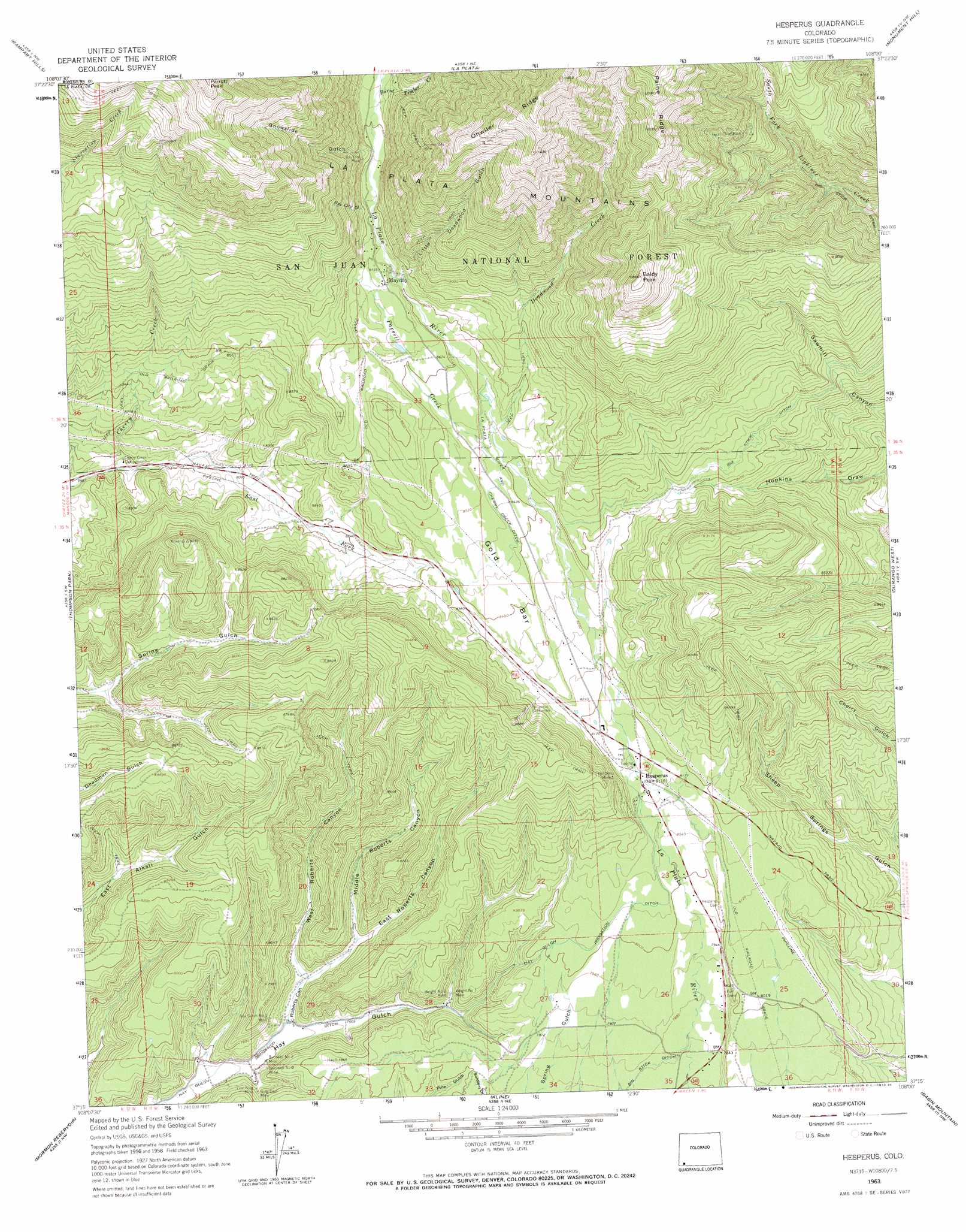
USGS Topo Quad 37108c1 - 1:24,000 scale
| Topo Map Name: | Hesperus |
| USGS Topo Quad ID: | 37108c1 |
| Print Size: | ca. 21 1/4" wide x 27" high |
| Southeast Coordinates: | 37.25° N latitude / 108° W longitude |
| Map Center Coordinates: | 37.3125° N latitude / 108.0625° W longitude |
| U.S. State: | CO |
| Filename: | o37108c1.jpg |
| Download Map JPG Image: | Hesperus topo map 1:24,000 scale |
| Map Type: | Topographic |
| Topo Series: | 7.5´ |
| Map Scale: | 1:24,000 |
| Source of Map Images: | United States Geological Survey (USGS) |
| Alternate Map Versions: |
Hesperus CO 1963, updated 1965 Download PDF Buy paper map Hesperus CO 1963, updated 1965 Download PDF Buy paper map Hesperus CO 1963, updated 1973 Download PDF Buy paper map Hesperus CO 1963, updated 1973 Download PDF Buy paper map Hesperus CO 2011 Download PDF Buy paper map Hesperus CO 2013 Download PDF Buy paper map Hesperus CO 2016 Download PDF Buy paper map |
| FStopo: | US Forest Service topo Hesperus is available: Download FStopo PDF Download FStopo TIF |
1:24,000 Topo Quads surrounding Hesperus
Stoner |
Wallace Ranch |
Orphan Butte |
Elk Creek |
Electra Lake |
Millwood |
Rampart Hills |
La Plata |
Monument Hill |
Hermosa |
Mancos |
Thompson Park |
Hesperus |
Durango West |
Durango East |
Trail Canyon |
Mormon Reservoir |
Kline |
Basin Mountain |
Loma Linda |
Red Horse Gulch |
Redmesa |
Pinkerton Mesa |
Long Mountain |
Bondad Hill |
> Back to 37108a1 at 1:100,000 scale
> Back to 37108a1 at 1:250,000 scale
> Back to U.S. Topo Maps home
Hesperus topo map: Gazetteer
Hesperus: Canals
Big Stick Ditch elevation 2584m 8477′La Plata River and Cherry Creek Ditch elevation 2588m 8490′
Hesperus: Flats
Gold Bar elevation 2572m 8438′Hesperus: Mines
Bay City Mine elevation 2726m 8943′Blackhawk Mine elevation 2474m 8116′
Blue Flame Mine elevation 2270m 7447′
Brawner Tunnel Mine elevation 2474m 8116′
Burnwell Mine Number 1 elevation 2271m 7450′
Burnwell Mine Number 2 elevation 2257m 7404′
Carbon Junction Strip Mine elevation 2291m 7516′
Coal King Mine elevation 2260m 7414′
Cunningham Mine elevation 2670m 8759′
Escalante Mine elevation 2474m 8116′
Farmer Boy Mine elevation 3006m 9862′
Former Bay Mine elevation 2979m 9773′
Golden Girl Mine elevation 2474m 8116′
Gustas Brothers Mine elevation 2793m 9163′
Hay Gulch Mine Number 1 elevation 2332m 7650′
Hesperus Mine elevation 2543m 8343′
Hesperus Mine elevation 3288m 10787′
Idaho Mine elevation 2701m 8861′
Inca Claims elevation 3391m 11125′
Jumbo Mine elevation 2747m 9012′
King Coal Mine elevation 2266m 7434′
King Mine elevation 2278m 7473′
Klondyke Mine elevation 2625m 8612′
Lady Eleanora Mine elevation 2673m 8769′
Little Nona Mine elevation 2702m 8864′
Lucky Four Mine elevation 3292m 10800′
Mammoth Mine elevation 3093m 10147′
May Day Mine elevation 2813m 9229′
Minoletti Mine elevation 2316m 7598′
Morovoratz Mine elevation 2699m 8854′
Oro Negro Group Mine elevation 3016m 9895′
Pat Lode Mine elevation 2474m 8116′
Rasmussen Mine elevation 2381m 7811′
Ruby Tunnel Mine elevation 2768m 9081′
Small Hope Mine elevation 2394m 7854′
Southern Boy and Girl Mine elevation 3028m 9934′
Supreme Mine elevation 2394m 7854′
Texas Chief Mine elevation 2986m 9796′
Ute Mine elevation 2722m 8930′
Van Emmett Mine elevation 3391m 11125′
Western View Mining Group Mine elevation 2707m 8881′
Wright Number 1 Mine elevation 2331m 7647′
Wright Number 2 Mine elevation 2333m 7654′
Hesperus: Populated Places
Hesperus elevation 2466m 8090′Mayday elevation 2662m 8733′
Hesperus: Ridges
Ohwiler Ridge elevation 3573m 11722′Paine Ridge elevation 3384m 11102′
Hesperus: Streams
Burnt Timber Creek elevation 2695m 8841′Deadwood Creek elevation 2573m 8441′
East Fork Cherry Creek elevation 2415m 7923′
Parrott Creek elevation 2568m 8425′
Hesperus: Summits
Baldy Peak elevation 3307m 10849′Parrott Peak elevation 3613m 11853′
Hesperus: Valleys
Bay City Gulch elevation 2676m 8779′East Roberts Canyon elevation 2367m 7765′
Little Deadwood Gulch elevation 2647m 8684′
Middle Roberts Canyon elevation 2367m 7765′
Roberts Canyon elevation 2265m 7431′
Snowslide Gulch elevation 2693m 8835′
West Roberts Canyon elevation 2282m 7486′
Hesperus digital topo map on disk
Buy this Hesperus topo map showing relief, roads, GPS coordinates and other geographical features, as a high-resolution digital map file on DVD: