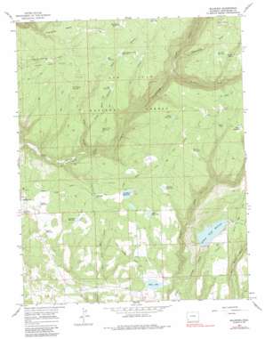
Millwood Topo Map Colorado
To zoom in, hover over the map of Millwood
USGS Topo Quad 37108d3 - 1:24,000 scale
| Topo Map Name: | Millwood |
| USGS Topo Quad ID: | 37108d3 |
| Print Size: | ca. 21 1/4" wide x 27" high |
| Southeast Coordinates: | 37.375° N latitude / 108.25° W longitude |
| Map Center Coordinates: | 37.4375° N latitude / 108.3125° W longitude |
| U.S. State: | CO |
| Filename: | o37108d3.jpg |
| Download Map JPG Image: | Millwood topo map 1:24,000 scale |
| Map Type: | Topographic |
| Topo Series: | 7.5´ |
| Map Scale: | 1:24,000 |
| Source of Map Images: | United States Geological Survey (USGS) |
| Alternate Map Versions: |
Millwood CO 1965, updated 1968 Download PDF Buy paper map Millwood CO 1965, updated 1968 Download PDF Buy paper map Millwood CO 1965, updated 1983 Download PDF Buy paper map Millwood CO 1965, updated 1987 Download PDF Buy paper map Millwood CO 1965, updated 1987 Download PDF Buy paper map Millwood CO 2011 Download PDF Buy paper map Millwood CO 2013 Download PDF Buy paper map Millwood CO 2016 Download PDF Buy paper map |
| FStopo: | US Forest Service topo Millwood is available: Download FStopo PDF Download FStopo TIF |
1:24,000 Topo Quads surrounding Millwood
> Back to 37108a1 at 1:100,000 scale
> Back to 37108a1 at 1:250,000 scale
> Back to U.S. Topo Maps home
Millwood topo map: Gazetteer
Millwood: Areas
Haycamp Mesa elevation 2478m 8129′Millwood: Canals
Joe Moore Ditch elevation 2291m 7516′Lost Canyon Ditch elevation 2260m 7414′
Turkey Creek Ditch elevation 2588m 8490′
Millwood: Dams
Bauer Lake Number 1 Dam elevation 2339m 7673′Bauer Lake Number 2 Dam elevation 2211m 7253′
Big Pine Dam elevation 2338m 7670′
Coppinger Number 1 Dam elevation 2265m 7431′
Hurst Dam elevation 2234m 7329′
Jackson Gulch Dam elevation 2461m 8074′
L A Bar Dam elevation 2389m 7837′
Sellers and McClane Dam elevation 2345m 7693′
Wallace Number 1 Dam elevation 2313m 7588′
Millwood: Lakes
Spruce Lake elevation 2572m 8438′Millwood: Mines
Vulcan Placer Mine elevation 2414m 7919′Millwood: Populated Places
Millwood elevation 2324m 7624′Millwood: Reservoirs
Adams Reservoir elevation 2263m 7424′Apple Tree Reservoir elevation 2426m 7959′
Bauer Lake elevation 2212m 7257′
Bauer Reservoir Number 1 elevation 2339m 7673′
Bauer Reservoir Number 2 elevation 2211m 7253′
Big Pine Reservoir elevation 2338m 7670′
Burnt Logs Reservoir elevation 2427m 7962′
Coppinger Reservoir elevation 2276m 7467′
Coppinger Reservoir Number 1 elevation 2265m 7431′
Hackley Reservoir elevation 2385m 7824′
Hallar Reservoir elevation 2522m 8274′
Hamlin Reservoir elevation 2492m 8175′
Hurst Reservoir elevation 2234m 7329′
Iron Spring Reservoir elevation 2429m 7969′
Jackson Gulch Reservoir elevation 2461m 8074′
Joe Moore Reservoir elevation 2346m 7696′
L A Bar Reservoir elevation 2389m 7837′
Little Bauer Reservoir elevation 2340m 7677′
Little Buck Reservoir elevation 2483m 8146′
Little Mud Reservoir elevation 2578m 8458′
Lumber Company Reservoir elevation 2653m 8704′
Millset Reservoir elevation 2588m 8490′
Mud Spring Reservoir elevation 2524m 8280′
Old Logging Camp Reservoir elevation 2512m 8241′
Sellers and McClane Reservoir elevation 2345m 7693′
Two Pine Reservoir elevation 2630m 8628′
Wallace Number 1 Reservoir elevation 2313m 7588′
West Buck Reservoir elevation 2512m 8241′
Millwood: Streams
Turkey Creek elevation 2387m 7831′Millwood: Valleys
Cox Canyon elevation 2333m 7654′Groundhog Gulch elevation 2381m 7811′
Jackson Gulch elevation 2204m 7230′
Little Buck Canyon elevation 2371m 7778′
Rock Canyon elevation 2281m 7483′
Millwood digital topo map on disk
Buy this Millwood topo map showing relief, roads, GPS coordinates and other geographical features, as a high-resolution digital map file on DVD:


