Willow Spring Topo Map Colorado
To zoom in, hover over the map of Willow Spring
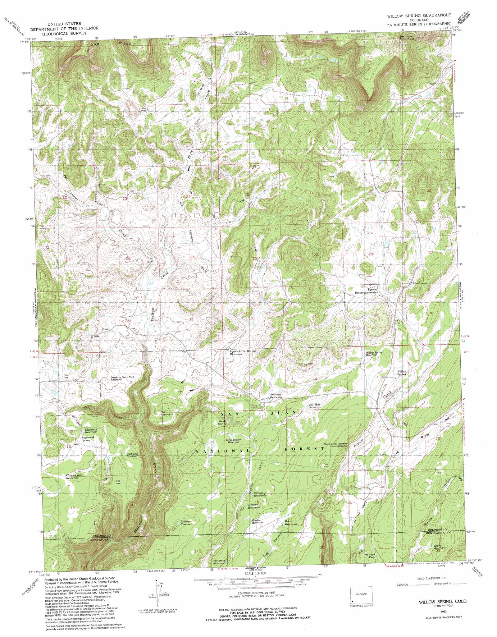
USGS Topo Quad 37108f4 - 1:24,000 scale
| Topo Map Name: | Willow Spring |
| USGS Topo Quad ID: | 37108f4 |
| Print Size: | ca. 21 1/4" wide x 27" high |
| Southeast Coordinates: | 37.625° N latitude / 108.375° W longitude |
| Map Center Coordinates: | 37.6875° N latitude / 108.4375° W longitude |
| U.S. State: | CO |
| Filename: | o37108f4.jpg |
| Download Map JPG Image: | Willow Spring topo map 1:24,000 scale |
| Map Type: | Topographic |
| Topo Series: | 7.5´ |
| Map Scale: | 1:24,000 |
| Source of Map Images: | United States Geological Survey (USGS) |
| Alternate Map Versions: |
Willow Spring CO 1965, updated 1967 Download PDF Buy paper map Willow Spring CO 1965, updated 1967 Download PDF Buy paper map Willow Spring CO 1993, updated 1993 Download PDF Buy paper map Willow Spring CO 2011 Download PDF Buy paper map Willow Spring CO 2013 Download PDF Buy paper map Willow Spring CO 2016 Download PDF Buy paper map |
| FStopo: | US Forest Service topo Willow Spring is available: Download FStopo PDF Download FStopo TIF |
1:24,000 Topo Quads surrounding Willow Spring
Dawson Draw |
Mckenna Peak |
North Mountain |
Lone Cone |
Beaver Park |
The Glade |
Glade Mountain |
South Mountain |
Groundhog Reservoir |
Groundhog Mountain |
Doe Canyon |
Narraguinnep Mountain |
Willow Spring |
Nipple Mountain |
Clyde Lake |
Yellow Jacket |
Trimble Point |
Boggy Draw |
Stoner |
Wallace Ranch |
Arriola |
Dolores West |
Dolores East |
Millwood |
Rampart Hills |
> Back to 37108e1 at 1:100,000 scale
> Back to 37108a1 at 1:250,000 scale
> Back to U.S. Topo Maps home
Willow Spring topo map: Gazetteer
Willow Spring: Flats
McPhee Park elevation 2465m 8087′Willow Spring: Mines
North Star Mine elevation 2448m 8031′Willow Spring: Reservoirs
Andrews Reservoir elevation 2380m 7808′Beaver Point Number 2 Reservoir elevation 2421m 7942′
Beaver Reservoir elevation 2434m 7985′
California Reservoir elevation 2407m 7896′
Carlyle Reservoir elevation 2424m 7952′
Carlysle Number 2 Reservoir elevation 2424m 7952′
Devere Reservoir elevation 2494m 8182′
Dunham Place Number 2 Reservoir elevation 2341m 7680′
East Lake Reservoir elevation 2398m 7867′
Eldon Reservoir elevation 2495m 8185′
Elk Reservoir elevation 2366m 7762′
Gordon Reservoir elevation 2430m 7972′
Henry Reservoir elevation 2474m 8116′
Johnson Reservoir elevation 2426m 7959′
Little Beaver Number 2 Reservoir elevation 2366m 7762′
Little Beaver Number 3 Reservoir elevation 2401m 7877′
Little Beaver Reservoir elevation 2384m 7821′
Middle Number 1 Reservoir elevation 2407m 7896′
Middle Number 2 Reservoir elevation 2416m 7926′
Middle Number 3 Reservoir elevation 2427m 7962′
Middle Number 4 Reservoir elevation 2371m 7778′
Middle Number 5 Reservoir elevation 2403m 7883′
Needed Reservoir elevation 2317m 7601′
New Reservoir elevation 2494m 8182′
Old Station Reservoir elevation 2443m 8015′
Plateau Reservoir elevation 2413m 7916′
Plateau Rim Reservoir elevation 2415m 7923′
Pot Hole Reservoir elevation 2414m 7919′
Ranger Reservoir elevation 2426m 7959′
Rocky Draw Number 5 Reservoir elevation 2452m 8044′
Sagebrush Reservoir elevation 2401m 7877′
Upper Beaver Reservoir elevation 2467m 8093′
Upper Little Beaver Reservoir elevation 2343m 7687′
Willow Spring Reservoir elevation 2449m 8034′
Willow Spring: Springs
Rusty Spring elevation 2354m 7723′Sagebrush Spring elevation 2405m 7890′
Willow Spring elevation 2444m 8018′
Willow Spring: Streams
Calf Creek elevation 2234m 7329′Summer Camp Creek elevation 2304m 7559′
Willow Spring: Summits
Belmear Mountain elevation 2940m 9645′Willow Spring: Valleys
Long Draw elevation 2413m 7916′Willow Spring digital topo map on disk
Buy this Willow Spring topo map showing relief, roads, GPS coordinates and other geographical features, as a high-resolution digital map file on DVD: