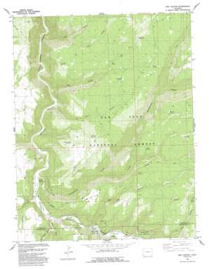
Doe Canyon Topo Map Colorado
To zoom in, hover over the map of Doe Canyon
USGS Topo Quad 37108f6 - 1:24,000 scale
| Topo Map Name: | Doe Canyon |
| USGS Topo Quad ID: | 37108f6 |
| Print Size: | ca. 21 1/4" wide x 27" high |
| Southeast Coordinates: | 37.625° N latitude / 108.625° W longitude |
| Map Center Coordinates: | 37.6875° N latitude / 108.6875° W longitude |
| U.S. State: | CO |
| Filename: | o37108f6.jpg |
| Download Map JPG Image: | Doe Canyon topo map 1:24,000 scale |
| Map Type: | Topographic |
| Topo Series: | 7.5´ |
| Map Scale: | 1:24,000 |
| Source of Map Images: | United States Geological Survey (USGS) |
| Alternate Map Versions: |
Doe Canyon CO 1965, updated 1968 Download PDF Buy paper map Doe Canyon CO 1965, updated 1968 Download PDF Buy paper map Doe Canyon CO 1993, updated 1993 Download PDF Buy paper map Doe Canyon CO 2011 Download PDF Buy paper map Doe Canyon CO 2013 Download PDF Buy paper map Doe Canyon CO 2016 Download PDF Buy paper map |
| FStopo: | US Forest Service topo Doe Canyon is available: Download FStopo PDF Download FStopo TIF |
1:24,000 Topo Quads surrounding Doe Canyon
> Back to 37108e1 at 1:100,000 scale
> Back to 37108a1 at 1:250,000 scale
> Back to U.S. Topo Maps home
Doe Canyon topo map: Gazetteer
Doe Canyon: Bridges
Bradfield Bridge elevation 1970m 6463′Doe Canyon: Parks
Bradfield Recreation Site elevation 1971m 6466′Cabin Canyon Recreation Site elevation 1988m 6522′
Dolores River State Wildlife Area elevation 2038m 6686′
Narraguinnep Natural Area elevation 2439m 8001′
Doe Canyon: Reservoirs
Ancil Reservoir elevation 2328m 7637′Arnold Reservoir elevation 2380m 7808′
Bradfield Reservoir elevation 2474m 8116′
Cheap Reservoir elevation 2244m 7362′
Corner Reservoir elevation 2468m 8097′
Doe Point Reservoir elevation 2315m 7595′
Doe Reseeding Reservoir elevation 2232m 7322′
Fence Line Reservoir elevation 2318m 7604′
Five Pine Reservoir elevation 2293m 7522′
Five Pines Reservoir Number Two elevation 2389m 7837′
Flatiron Reservoir elevation 2500m 8202′
Floating Reservoir elevation 2283m 7490′
Gravel Pit Reservoir elevation 2250m 7381′
Hydrolic Reservoir elevation 2335m 7660′
Lake Clydia Reservoir elevation 2390m 7841′
Lone Dome Reservoir elevation 2378m 7801′
Lost Park Reservoir elevation 2293m 7522′
McClure Reservoir elevation 2447m 8028′
Pee Wee Reservoir elevation 2313m 7588′
Pine Reservoir elevation 2371m 7778′
Powerline Number Three Reservoir elevation 2292m 7519′
Rabit Hash Reservoir elevation 2294m 7526′
Runt Reservoir elevation 2304m 7559′
Side Canyon Reservoir elevation 2397m 7864′
Study Plot Reservoir elevation 2240m 7349′
Doe Canyon: Springs
Canyon Spring elevation 2229m 7312′Doe Spring elevation 2365m 7759′
Ferris Spring elevation 2403m 7883′
Doe Canyon: Streams
Canyon Creek elevation 1967m 6453′Doe Canyon: Summits
Ormiston Point elevation 2333m 7654′Doe Canyon: Trails
Ormiston Point Stock Driveway elevation 2342m 7683′Doe Canyon: Valleys
Alkali Canyon elevation 2346m 7696′Cabin Canyon elevation 1994m 6541′
Cow Canyon elevation 2122m 6961′
Doe Canyon elevation 1960m 6430′
Far Draw elevation 2249m 7378′
Five Pine Canyon elevation 1977m 6486′
Lake Canyon elevation 1943m 6374′
Narraguinnep Canyon elevation 1975m 6479′
Near Draw elevation 2485m 8152′
Ryman Draw elevation 1980m 6496′
West Ryman Draw elevation 2006m 6581′
Williams Draw elevation 1980m 6496′
Doe Canyon digital topo map on disk
Buy this Doe Canyon topo map showing relief, roads, GPS coordinates and other geographical features, as a high-resolution digital map file on DVD:


