Cahone Topo Map Colorado
To zoom in, hover over the map of Cahone
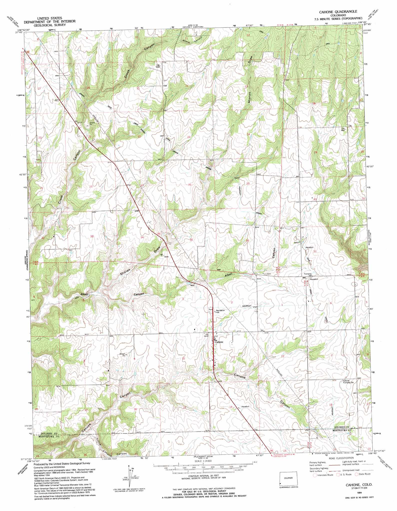
USGS Topo Quad 37108f7 - 1:24,000 scale
| Topo Map Name: | Cahone |
| USGS Topo Quad ID: | 37108f7 |
| Print Size: | ca. 21 1/4" wide x 27" high |
| Southeast Coordinates: | 37.625° N latitude / 108.75° W longitude |
| Map Center Coordinates: | 37.6875° N latitude / 108.8125° W longitude |
| U.S. State: | CO |
| Filename: | o37108f7.jpg |
| Download Map JPG Image: | Cahone topo map 1:24,000 scale |
| Map Type: | Topographic |
| Topo Series: | 7.5´ |
| Map Scale: | 1:24,000 |
| Source of Map Images: | United States Geological Survey (USGS) |
| Alternate Map Versions: |
Cahone CO 1965, updated 1967 Download PDF Buy paper map Cahone CO 1965, updated 1984 Download PDF Buy paper map Cahone CO 1994, updated 1994 Download PDF Buy paper map Cahone CO 2010 Download PDF Buy paper map Cahone CO 2013 Download PDF Buy paper map Cahone CO 2016 Download PDF Buy paper map |
| FStopo: | US Forest Service topo Cahone is available: Download FStopo PDF Download FStopo TIF |
1:24,000 Topo Quads surrounding Cahone
Piute Point |
Egnar |
Joe Davis Hill |
Dawson Draw |
Mckenna Peak |
Northdale |
Dove Creek |
Secret Canyon |
The Glade |
Glade Mountain |
Burnt Cabin Creek |
Champagne Spring |
Cahone |
Doe Canyon |
Narraguinnep Mountain |
Papoose Canyon |
Ruin Canyon |
Pleasant View |
Yellow Jacket |
Trimble Point |
Ruin Point |
Negro Canyon |
Woods Canyon |
Arriola |
Dolores West |
> Back to 37108e1 at 1:100,000 scale
> Back to 37108a1 at 1:250,000 scale
> Back to U.S. Topo Maps home
Cahone topo map: Gazetteer
Cahone: Populated Places
Cahone elevation 2036m 6679′Cahone: Reservoirs
Dove Reservoir elevation 2314m 7591′Mel Dalton Number One Reservoir elevation 2323m 7621′
Sagebrush Number One Reservoir elevation 2275m 7463′
Cahone: Valleys
Alkali Draw elevation 1928m 6325′Little Cahone Canyon elevation 1947m 6387′
Sharp Canyon elevation 2176m 7139′
Sharps Draw elevation 1955m 6414′
Cahone digital topo map on disk
Buy this Cahone topo map showing relief, roads, GPS coordinates and other geographical features, as a high-resolution digital map file on DVD: