Little Cone Topo Map Colorado
To zoom in, hover over the map of Little Cone
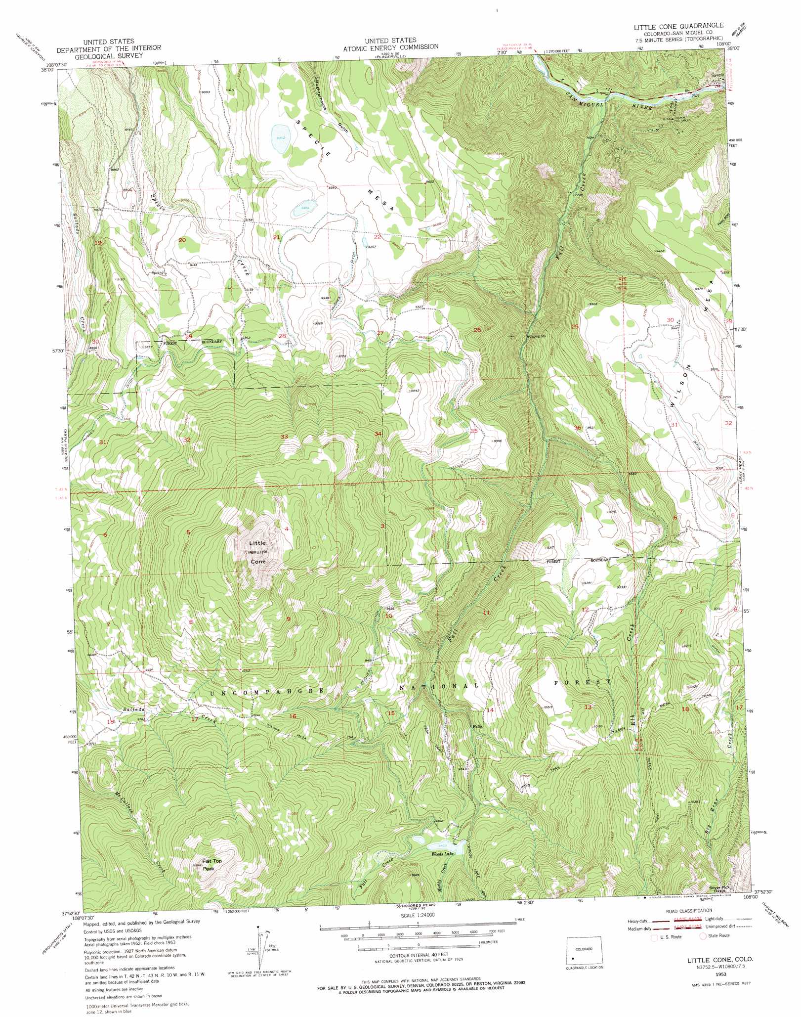
USGS Topo Quad 37108h1 - 1:24,000 scale
| Topo Map Name: | Little Cone |
| USGS Topo Quad ID: | 37108h1 |
| Print Size: | ca. 21 1/4" wide x 27" high |
| Southeast Coordinates: | 37.875° N latitude / 108° W longitude |
| Map Center Coordinates: | 37.9375° N latitude / 108.0625° W longitude |
| U.S. State: | CO |
| Filename: | o37108h1.jpg |
| Download Map JPG Image: | Little Cone topo map 1:24,000 scale |
| Map Type: | Topographic |
| Topo Series: | 7.5´ |
| Map Scale: | 1:24,000 |
| Source of Map Images: | United States Geological Survey (USGS) |
| Alternate Map Versions: |
Little Cone CO 1953, updated 1955 Download PDF Buy paper map Little Cone CO 1953, updated 1955 Download PDF Buy paper map Little Cone CO 1953, updated 1965 Download PDF Buy paper map Little Cone CO 1953, updated 1970 Download PDF Buy paper map Little Cone CO 1953, updated 1970 Download PDF Buy paper map Little Cone CO 1953, updated 1978 Download PDF Buy paper map Little Cone CO 2011 Download PDF Buy paper map Little Cone CO 2013 Download PDF Buy paper map Little Cone CO 2016 Download PDF Buy paper map |
| FStopo: | US Forest Service topo Little Cone is available: Download FStopo PDF Download FStopo TIF |
1:24,000 Topo Quads surrounding Little Cone
Norwood |
Sanborn Park |
Hotchkiss Reservoir |
Horsefly Peak |
Ridgway |
Oak Hill |
Gurley Canyon |
Placerville |
Sams |
Mount Sneffels |
Lone Cone |
Beaver Park |
Little Cone |
Gray Head |
Telluride |
Groundhog Reservoir |
Groundhog Mountain |
Dolores Peak |
Mount Wilson |
Ophir |
Nipple Mountain |
Clyde Lake |
Rico |
Hermosa Peak |
Engineer Mountain |
> Back to 37108e1 at 1:100,000 scale
> Back to 37108a1 at 1:250,000 scale
> Back to U.S. Topo Maps home
Little Cone topo map: Gazetteer
Little Cone: Canals
Hughes Ditch elevation 2856m 9370′Little Cone: Lakes
Woods Lake elevation 2874m 9429′Little Cone: Mines
Binkley-Sawpit Project Mine elevation 2332m 7650′Fall Creek Quarry elevation 2607m 8553′
Gilt Edge Mine elevation 2941m 9648′
Golden Era Mine elevation 2332m 7650′
Lizzie G Mine elevation 2287m 7503′
Lone Tree Mine elevation 2308m 7572′
New Discovery Mine elevation 2869m 9412′
Old Man Mine elevation 2865m 9399′
Stella Mine elevation 2869m 9412′
Unaweep Mine elevation 2332m 7650′
Little Cone: Populated Places
Sawpit elevation 2314m 7591′Little Cone: Streams
Elk Creek elevation 2481m 8139′Fall Creek elevation 2271m 7450′
Muddy Creek elevation 2874m 9429′
Little Cone: Summits
Flat Top Peak elevation 3529m 11578′Little Cone elevation 3653m 11984′
Specie Mesa elevation 2968m 9737′
Little Cone: Trails
Elk Creek Trail elevation 3146m 10321′Wilson Mesa Trail elevation 2975m 9760′
Little Cone digital topo map on disk
Buy this Little Cone topo map showing relief, roads, GPS coordinates and other geographical features, as a high-resolution digital map file on DVD: