Dawson Draw Topo Map Colorado
To zoom in, hover over the map of Dawson Draw
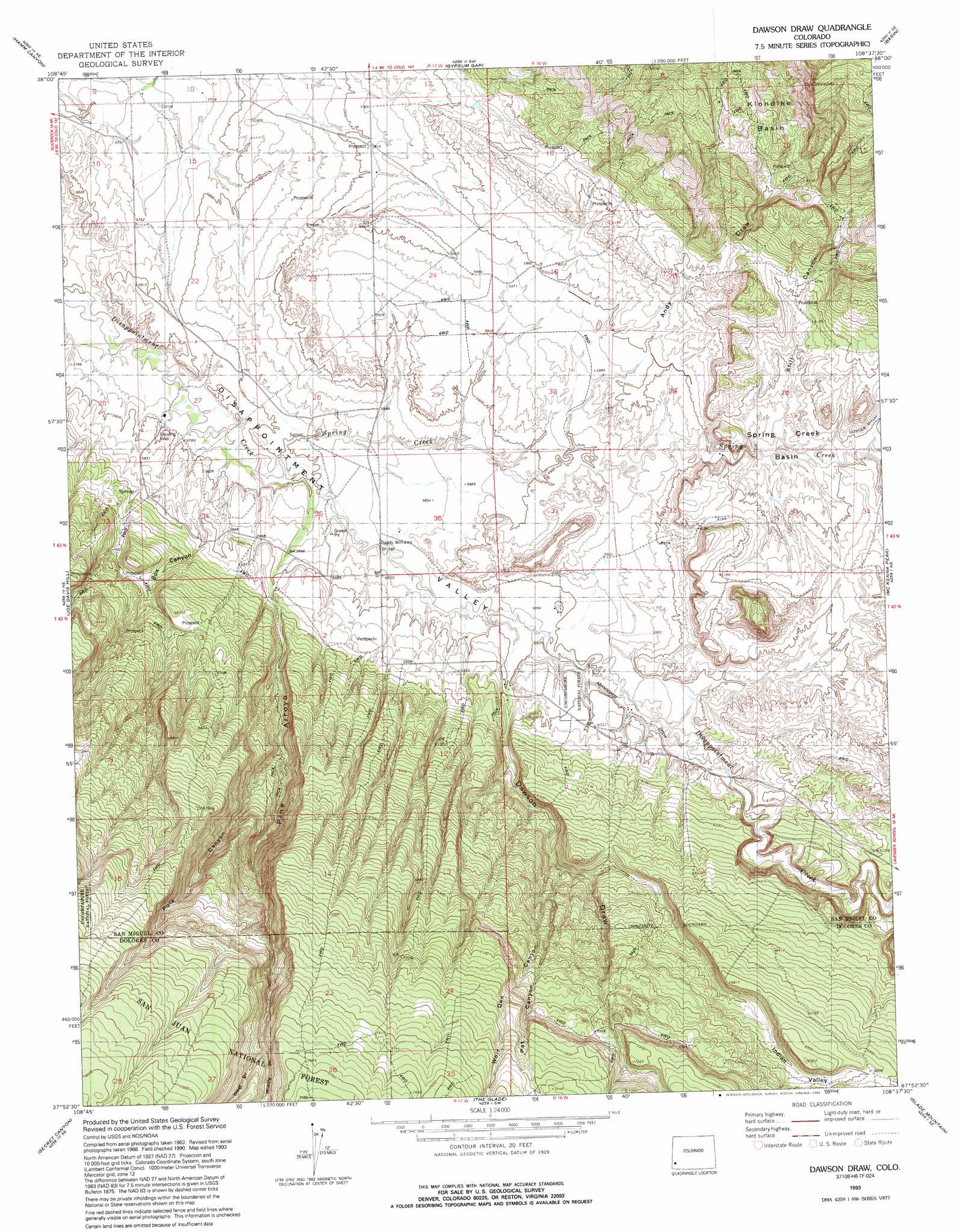
USGS Topo Quad 37108h6 - 1:24,000 scale
| Topo Map Name: | Dawson Draw |
| USGS Topo Quad ID: | 37108h6 |
| Print Size: | ca. 21 1/4" wide x 27" high |
| Southeast Coordinates: | 37.875° N latitude / 108.625° W longitude |
| Map Center Coordinates: | 37.9375° N latitude / 108.6875° W longitude |
| U.S. State: | CO |
| Filename: | o37108h6.jpg |
| Download Map JPG Image: | Dawson Draw topo map 1:24,000 scale |
| Map Type: | Topographic |
| Topo Series: | 7.5´ |
| Map Scale: | 1:24,000 |
| Source of Map Images: | United States Geological Survey (USGS) |
| Alternate Map Versions: |
Dawson Draw CO 1964, updated 1968 Download PDF Buy paper map Dawson Draw CO 1964, updated 1968 Download PDF Buy paper map Dawson Draw CO 1964, updated 1991 Download PDF Buy paper map Dawson Draw CO 1993, updated 1993 Download PDF Buy paper map Dawson Draw CO 2011 Download PDF Buy paper map Dawson Draw CO 2013 Download PDF Buy paper map Dawson Draw CO 2016 Download PDF Buy paper map |
| FStopo: | US Forest Service topo Dawson Draw is available: Download FStopo PDF Download FStopo TIF |
1:24,000 Topo Quads surrounding Dawson Draw
Anderson Mesa |
Bull Canyon |
Naturita Nw |
Naturita |
Redvale |
Horse Range Mesa |
Hamm Canyon |
Gypsum Gap |
Basin |
Barkelew Draw |
Egnar |
Joe Davis Hill |
Dawson Draw |
Mckenna Peak |
North Mountain |
Dove Creek |
Secret Canyon |
The Glade |
Glade Mountain |
South Mountain |
Champagne Spring |
Cahone |
Doe Canyon |
Narraguinnep Mountain |
Willow Spring |
> Back to 37108e1 at 1:100,000 scale
> Back to 37108a1 at 1:250,000 scale
> Back to U.S. Topo Maps home
Dawson Draw topo map: Gazetteer
Dawson Draw: Basins
Klondike Basin elevation 1977m 6486′Dawson Draw: Bridges
Daddy Williams Bridge elevation 1777m 5830′Dawson Draw: Canals
Custer Ditch elevation 1861m 6105′Horseshoe Ditch elevation 1759m 5770′
McCulloch Creek Ditch elevation 1904m 6246′
Dawson Draw: Mines
Brown Mule Mine elevation 1903m 6243′Hidden Treasure Mine elevation 1794m 5885′
Hornet Mine elevation 1821m 5974′
Margaret C. 1-6 Mine elevation 1932m 6338′
North Continent Mine elevation 1794m 5885′
Victor Mine elevation 1903m 6243′
Windy Day Mine elevation 2017m 6617′
Dawson Draw: Streams
Spring Creek elevation 1763m 5784′Dawson Draw: Valleys
Andy Draw elevation 1797m 5895′Box Canyon elevation 1801m 5908′
Dawson Draw elevation 1793m 5882′
Indian Valley elevation 1947m 6387′
Middle Branch Pine Arroyo elevation 2241m 7352′
Pat Canyon elevation 1942m 6371′
Pine Arroyo elevation 1763m 5784′
Pole Canyon elevation 1888m 6194′
Still Canyon elevation 1836m 6023′
West Branch Pine Arroyo elevation 2241m 7352′
Wolf Den Canyon elevation 1878m 6161′
Dawson Draw digital topo map on disk
Buy this Dawson Draw topo map showing relief, roads, GPS coordinates and other geographical features, as a high-resolution digital map file on DVD: