Warren Canyon Topo Map Utah
To zoom in, hover over the map of Warren Canyon
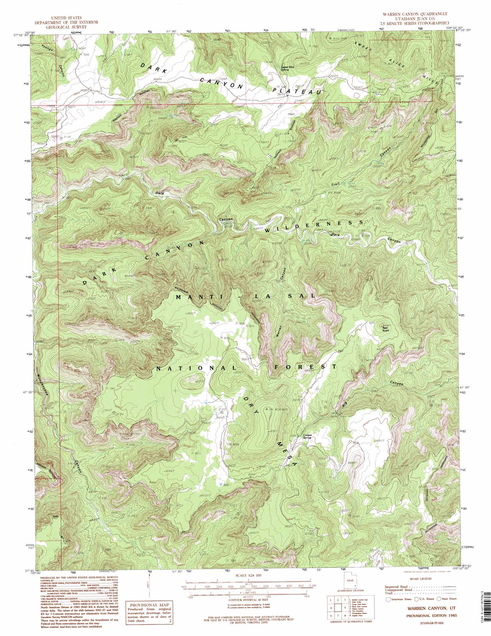
USGS Topo Quad 37109g8 - 1:24,000 scale
| Topo Map Name: | Warren Canyon |
| USGS Topo Quad ID: | 37109g8 |
| Print Size: | ca. 21 1/4" wide x 27" high |
| Southeast Coordinates: | 37.75° N latitude / 109.875° W longitude |
| Map Center Coordinates: | 37.8125° N latitude / 109.9375° W longitude |
| U.S. State: | UT |
| Filename: | o37109g8.jpg |
| Download Map JPG Image: | Warren Canyon topo map 1:24,000 scale |
| Map Type: | Topographic |
| Topo Series: | 7.5´ |
| Map Scale: | 1:24,000 |
| Source of Map Images: | United States Geological Survey (USGS) |
| Alternate Map Versions: |
Elk Ridge 2 SW UT 1954 Download PDF Buy paper map Warren Canyon UT 1985, updated 1985 Download PDF Buy paper map Warren Canyon UT 1985, updated 1995 Download PDF Buy paper map Warren Canyon UT 2001, updated 2004 Download PDF Buy paper map Warren Canyon UT 2011 Download PDF Buy paper map Warren Canyon UT 2014 Download PDF Buy paper map |
| FStopo: | US Forest Service topo Warren Canyon is available: Download FStopo PDF Download FStopo TIF |
1:24,000 Topo Quads surrounding Warren Canyon
Clearwater Canyon |
Teapot Rock |
Cross Canyon |
Druid Arch |
South Six-Shooter Peak |
Bowdie Canyon West |
Bowdie Canyon East |
Fable Valley |
House Park Butte |
Cathedral Butte |
Indian Head Pass |
Black Steer Canyon |
Warren Canyon |
Poison Canyon |
Chippean Rocks |
Jacobs Chair |
The Cheesebox |
Woodenshoe Buttes |
Kigalia Point |
Cream Pots |
Fry Spring |
Moss Back Butte |
Kane Gulch |
South Long Point |
Hotel Rock |
> Back to 37109e1 at 1:100,000 scale
> Back to 37108a1 at 1:250,000 scale
> Back to U.S. Topo Maps home
Warren Canyon topo map: Gazetteer
Warren Canyon: Reservoirs
Cooper Reservoir elevation 2486m 8156′Warren Canyon: Springs
Cooper Spring elevation 2474m 8116′Sweet Alice Spring elevation 2352m 7716′
Warren Canyon: Summits
Dry Mesa elevation 2697m 8848′Sweet Alice Hills elevation 2552m 8372′
Warren Canyon: Valleys
Trail Canyon elevation 1988m 6522′Warren Canyon elevation 1988m 6522′
Warren Canyon digital topo map on disk
Buy this Warren Canyon topo map showing relief, roads, GPS coordinates and other geographical features, as a high-resolution digital map file on DVD: