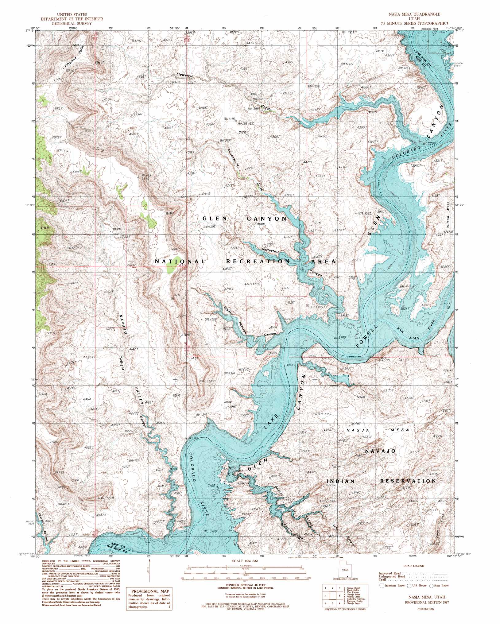
Nasja Mesa Topo Map Utah
To zoom in, hover over the map of Nasja Mesa
USGS Topo Quad 37110b8 - 1:24,000 scale
| Topo Map Name: | Nasja Mesa |
| USGS Topo Quad ID: | 37110b8 |
| Print Size: | ca. 21 1/4" wide x 27" high |
| Southeast Coordinates: | 37.125° N latitude / 110.875° W longitude |
| Map Center Coordinates: | 37.1875° N latitude / 110.9375° W longitude |
| U.S. State: | UT |
| Filename: | o37110b8.jpg |
| Download Map JPG Image: | Nasja Mesa topo map 1:24,000 scale |
| Map Type: | Topographic |
| Topo Series: | 7.5´ |
| Map Scale: | 1:24,000 |
| Source of Map Images: | United States Geological Survey (USGS) |
| Alternate Map Versions: |
Nasja Mesa UT 1987, updated 1988 Download PDF Buy paper map Nasja Mesa UT 1987, updated 1988 Download PDF Buy paper map Nasja Mesa UT 2011 Download PDF Buy paper map Nasja Mesa UT 2014 Download PDF Buy paper map |
1:24,000 Topo Quads surrounding Nasja Mesa
Big Hollow Wash |
King Mesa |
Stevens Canyon South |
The Rincon Ne |
Halls Crossing |
Blackburn Canyon |
Sooner Bench |
Davis Gulch |
The Rincon |
Alcove Canyon |
Mazuki Point |
Navajo Point |
Nasja Mesa |
Wilson Creek |
Deep Canyon North |
Gregory Butte |
Cathedral Canyon |
Rainbow Bridge |
Navajo Begay |
Deep Canyon South |
Face Canyon |
West Canyon Creek |
Chaiyahi Flat |
Chaiyahi Rim Ne |
Tall Mountain Nw |
> Back to 37110a1 at 1:100,000 scale
> Back to 37110a1 at 1:250,000 scale
> Back to U.S. Topo Maps home
Nasja Mesa topo map: Gazetteer
Nasja Mesa: Arches
Twilight Arch elevation 1129m 3704′Nasja Mesa: Bars
Music Temple Bar (historical) elevation 1129m 3704′Nasja Mesa: Capes
Fiftymile Point elevation 1807m 5928′Nasja Mesa: Islands
Register Rock elevation 1132m 3713′Nasja Mesa: Springs
Karnaba Spring (historical) elevation 1129m 3704′Melody Spring (historical) elevation 1129m 3704′
Nasja Mesa: Streams
San Juan River elevation 1129m 3704′Nasja Mesa: Summits
Nasja Mesa elevation 1365m 4478′Nasja Mesa: Trails
Hoskaninni Company Road elevation 1129m 3704′Nasja Mesa: Valleys
Anasazi Canyon elevation 1129m 3704′Cottonwood Canyon elevation 1129m 3704′
Cottonwood Gulch elevation 1129m 3704′
Hidden Passage Canyon elevation 1129m 3704′
Lehi Canyon elevation 1129m 3704′
Llewellyn Gulch elevation 1192m 3910′
Moepitz Canyon elevation 1129m 3704′
Navajo Valley elevation 1129m 3704′
Oak Canyon elevation 1129m 3704′
Reflection Canyon elevation 1129m 3704′
San Juan Valley elevation 1129m 3704′
Twilight Canyon elevation 1129m 3704′
Nasja Mesa digital topo map on disk
Buy this Nasja Mesa topo map showing relief, roads, GPS coordinates and other geographical features, as a high-resolution digital map file on DVD: