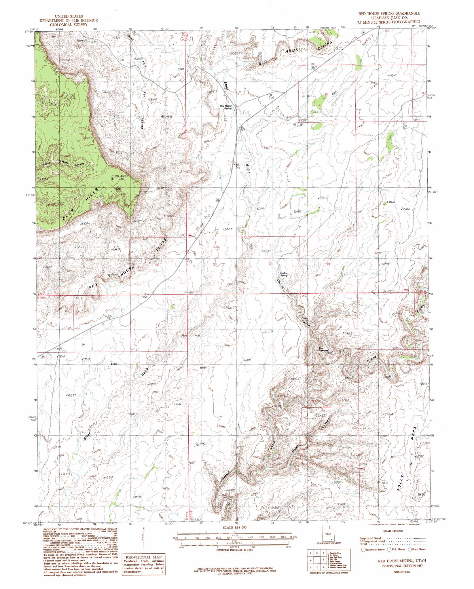
Red House Spring Topo Map Utah
To zoom in, hover over the map of Red House Spring
USGS Topo Quad 37110d2 - 1:24,000 scale
| Topo Map Name: | Red House Spring |
| USGS Topo Quad ID: | 37110d2 |
| Print Size: | ca. 21 1/4" wide x 27" high |
| Southeast Coordinates: | 37.375° N latitude / 110.125° W longitude |
| Map Center Coordinates: | 37.4375° N latitude / 110.1875° W longitude |
| U.S. State: | UT |
| Filename: | o37110d2.jpg |
| Download Map JPG Image: | Red House Spring topo map 1:24,000 scale |
| Map Type: | Topographic |
| Topo Series: | 7.5´ |
| Map Scale: | 1:24,000 |
| Source of Map Images: | United States Geological Survey (USGS) |
| Alternate Map Versions: |
Clay Hills 1 NW UT 1954, updated 1955 Download PDF Buy paper map Red House Spring UT 1987, updated 1987 Download PDF Buy paper map Red House Spring UT 1987, updated 1987 Download PDF Buy paper map Red House Spring UT 1996, updated 2002 Download PDF Buy paper map Red House Spring UT 1996, updated 2002 Download PDF Buy paper map Red House Spring UT 2011 Download PDF Buy paper map Red House Spring UT 2014 Download PDF Buy paper map |
1:24,000 Topo Quads surrounding Red House Spring
Good Hope Bay |
Mancos Mesa Ne |
Jacobs Chair |
The Cheesebox |
Woodenshoe Buttes |
Mancos Mesa |
Chocolate Drop |
Fry Spring |
Moss Back Butte |
Kane Gulch |
Burnt Spring |
Clay Hills |
Red House Spring |
Pollys Pasture |
Cedar Mesa North |
Mikes Mesa |
Whirlwind Draw |
Slickhorn Canyon West |
Slickhorn Canyon East |
Cedar Mesa South |
Monitor Butte |
Oljeto Ne |
Goulding Nw |
Goulding Ne |
The Goosenecks |
> Back to 37110a1 at 1:100,000 scale
> Back to 37110a1 at 1:250,000 scale
> Back to U.S. Topo Maps home
Red House Spring topo map: Gazetteer
Red House Spring: Gaps
The Narrows elevation 1465m 4806′Red House Spring: Lakes
Buckley Lake elevation 1447m 4747′Red House Spring: Springs
Bannister Spring elevation 1499m 4917′Big Pour Off Spring elevation 1530m 5019′
Collins Spring elevation 1538m 5045′
Red House Spring elevation 1574m 5164′
Red House Spring: Valleys
Collins Canyon elevation 1449m 4753′Deer Canyon elevation 1508m 4947′
False Trail Canyon elevation 1463m 4799′
Redman Canyon elevation 1436m 4711′
Water Canyon elevation 1419m 4655′
Red House Spring digital topo map on disk
Buy this Red House Spring topo map showing relief, roads, GPS coordinates and other geographical features, as a high-resolution digital map file on DVD: