Jacobs Chair Topo Map Utah
To zoom in, hover over the map of Jacobs Chair
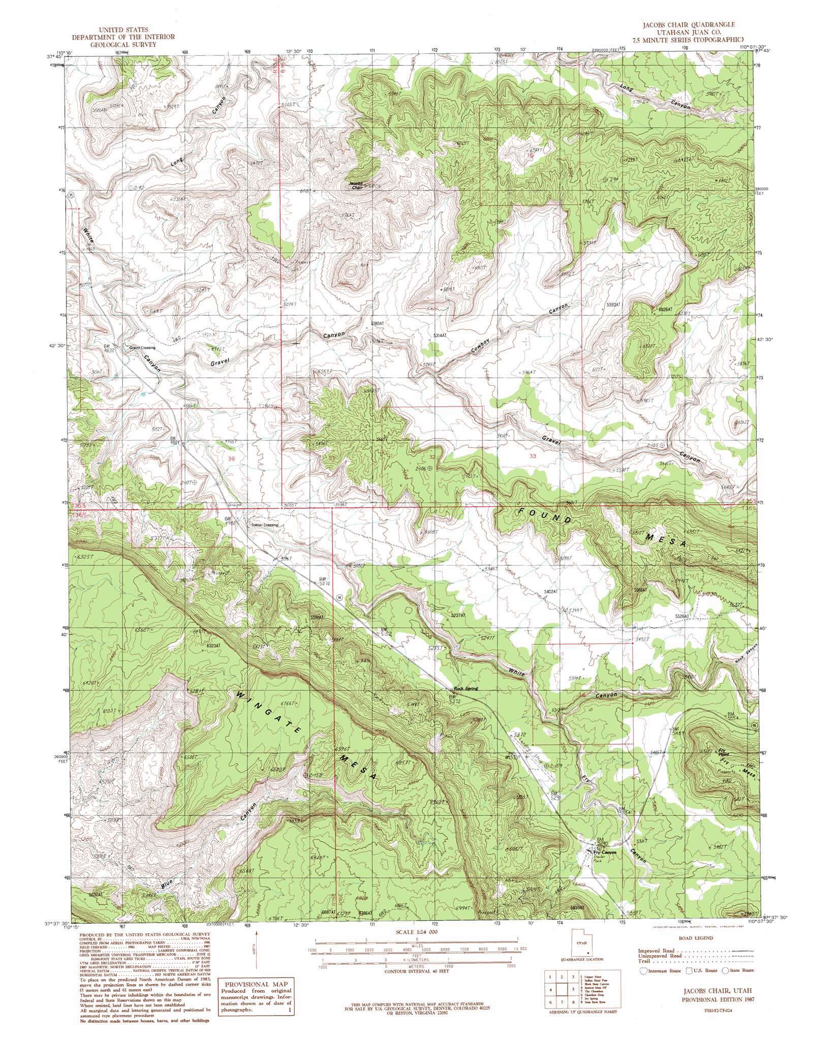
USGS Topo Quad 37110f2 - 1:24,000 scale
| Topo Map Name: | Jacobs Chair |
| USGS Topo Quad ID: | 37110f2 |
| Print Size: | ca. 21 1/4" wide x 27" high |
| Southeast Coordinates: | 37.625° N latitude / 110.125° W longitude |
| Map Center Coordinates: | 37.6875° N latitude / 110.1875° W longitude |
| U.S. State: | UT |
| Filename: | o37110f2.jpg |
| Download Map JPG Image: | Jacobs Chair topo map 1:24,000 scale |
| Map Type: | Topographic |
| Topo Series: | 7.5´ |
| Map Scale: | 1:24,000 |
| Source of Map Images: | United States Geological Survey (USGS) |
| Alternate Map Versions: |
White Canyon 4 NW UT 1954, updated 1954 Download PDF Buy paper map Jacobs Chair UT 1987, updated 1987 Download PDF Buy paper map Jacobs Chair UT 1996, updated 2002 Download PDF Buy paper map Jacobs Chair UT 2011 Download PDF Buy paper map Jacobs Chair UT 2014 Download PDF Buy paper map |
1:24,000 Topo Quads surrounding Jacobs Chair
Hite North |
Sewing Machine |
Bowdie Canyon West |
Bowdie Canyon East |
Fable Valley |
Hite South |
Copper Point |
Indian Head Pass |
Black Steer Canyon |
Warren Canyon |
Good Hope Bay |
Mancos Mesa Ne |
Jacobs Chair |
The Cheesebox |
Woodenshoe Buttes |
Mancos Mesa |
Chocolate Drop |
Fry Spring |
Moss Back Butte |
Kane Gulch |
Burnt Spring |
Clay Hills |
Red House Spring |
Pollys Pasture |
Cedar Mesa North |
> Back to 37110e1 at 1:100,000 scale
> Back to 37110a1 at 1:250,000 scale
> Back to U.S. Topo Maps home
Jacobs Chair topo map: Gazetteer
Jacobs Chair: Areas
Wingate Mesa elevation 2037m 6683′Jacobs Chair: Parks
Fry Canyon Store and RV Park elevation 1637m 5370′Jacobs Chair: Populated Places
Fry Canyon elevation 1638m 5374′Gravel Crossing elevation 1463m 4799′
Soldier Crossing elevation 1498m 4914′
Jacobs Chair: Springs
Rock Spring elevation 1610m 5282′Jacobs Chair: Summits
Fry Point elevation 1822m 5977′Jacobs Chair elevation 2065m 6774′
Jacobs Chair: Valleys
Cowboy Canyon elevation 1543m 5062′Fry Canyon elevation 1551m 5088′
Gravel Canyon elevation 1466m 4809′
Long Canyon elevation 1429m 4688′
Nook Canyon elevation 1611m 5285′
Jacobs Chair digital topo map on disk
Buy this Jacobs Chair topo map showing relief, roads, GPS coordinates and other geographical features, as a high-resolution digital map file on DVD: