Gunsight Butte Topo Map Utah
To zoom in, hover over the map of Gunsight Butte
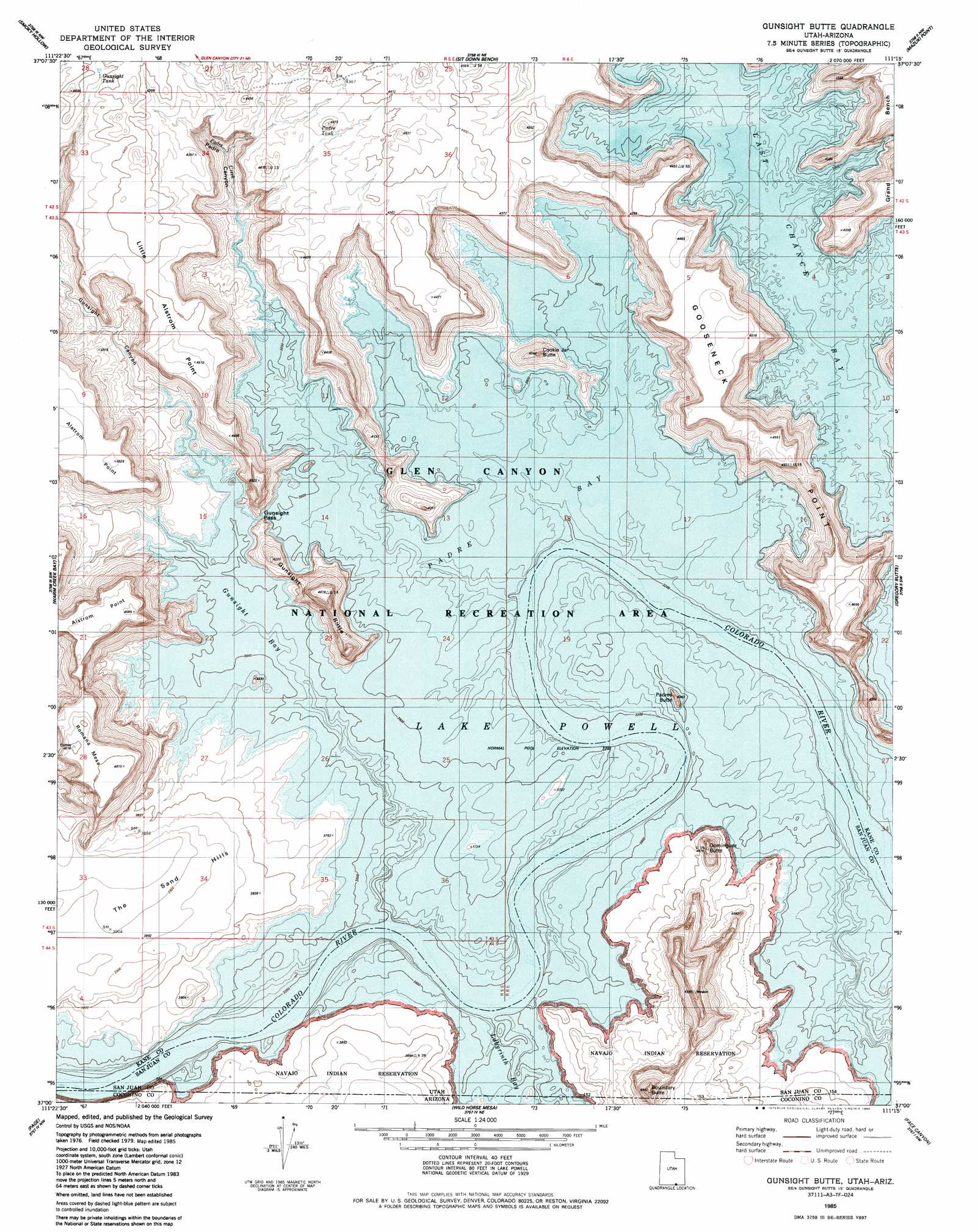
USGS Topo Quad 37111a3 - 1:24,000 scale
| Topo Map Name: | Gunsight Butte |
| USGS Topo Quad ID: | 37111a3 |
| Print Size: | ca. 21 1/4" wide x 27" high |
| Southeast Coordinates: | 37° N latitude / 111.25° W longitude |
| Map Center Coordinates: | 37.0625° N latitude / 111.3125° W longitude |
| U.S. States: | UT, AZ |
| Filename: | o37111a3.jpg |
| Download Map JPG Image: | Gunsight Butte topo map 1:24,000 scale |
| Map Type: | Topographic |
| Topo Series: | 7.5´ |
| Map Scale: | 1:24,000 |
| Source of Map Images: | United States Geological Survey (USGS) |
| Alternate Map Versions: |
Gunsight Butte UT 1985, updated 1985 Download PDF Buy paper map Gunsight Butte UT 2011 Download PDF Buy paper map Gunsight Butte UT 2014 Download PDF Buy paper map |
1:24,000 Topo Quads surrounding Gunsight Butte
Ship Mountain Point |
Needle Eye Point |
East Of The Navajo |
Blackburn Canyon |
Sooner Bench |
Tibbet Bench |
Smoky Hollow |
Sit Down Bench |
Mazuki Point |
Navajo Point |
Lone Rock |
Warm Creek Bay |
Gunsight Butte |
Gregory Butte |
Cathedral Canyon |
Ferry Swale |
Page |
Wild Horse Mesa |
Face Canyon |
West Canyon Creek |
Lees Ferry |
White Dome |
Leche-E Rock |
Cedar Tree Bench |
Tse Esgizii |
> Back to 37111a1 at 1:100,000 scale
> Back to 37110a1 at 1:250,000 scale
> Back to U.S. Topo Maps home
Gunsight Butte topo map: Gazetteer
Gunsight Butte: Bars
Gunsight Bar elevation 1129m 3704′Gunsight Butte: Bays
Gunsight Bay elevation 1129m 3704′Labyrinth Bay elevation 1129m 3704′
Labyrinth Bay elevation 1129m 3704′
Last Chance Bay elevation 1129m 3704′
Padre Bay elevation 1129m 3704′
Gunsight Butte: Capes
Alstrom Point elevation 1345m 4412′Kane Point elevation 1372m 4501′
Little Alstrom Point elevation 1349m 4425′
Padre Point elevation 1161m 3809′
Gunsight Butte: Crossings
Crossing of the Fathers (historical) elevation 1129m 3704′Gunsight Butte: Gaps
Gunsight Pass elevation 1171m 3841′Gunsight Butte: Reservoirs
Gunsight Tank elevation 1336m 4383′Padre Tank elevation 1317m 4320′
Gunsight Butte: Streams
Padre Creek elevation 1129m 3704′Gunsight Butte: Summits
Cookie Jar Butte elevation 1314m 4311′Dominguez Butte elevation 1358m 4455′
Gunsight Butte elevation 1413m 4635′
Padres Butte elevation 1186m 3891′
Romana Mesa elevation 1460m 4790′
The Sand Hills elevation 1190m 3904′
Gunsight Butte: Valleys
Center Fork Kane Wash elevation 1133m 3717′Face Canyon (historical) elevation 1129m 3704′
Gunsight Canyon elevation 1138m 3733′
Kane Wash (historical) elevation 1129m 3704′
Left Fork Kane Wash elevation 1130m 3707′
Mystery Canyon (historical) elevation 1129m 3704′
Padre Canyon elevation 1129m 3704′
Right Fork Kane Wash elevation 1331m 4366′
Gunsight Butte digital topo map on disk
Buy this Gunsight Butte topo map showing relief, roads, GPS coordinates and other geographical features, as a high-resolution digital map file on DVD: