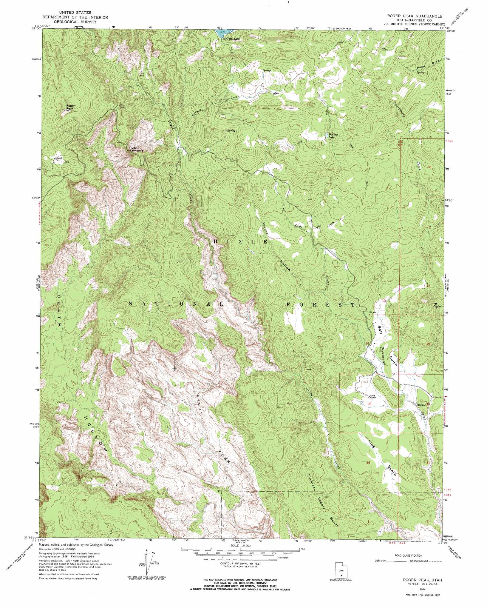
Roger Peak Topo Map Utah
To zoom in, hover over the map of Roger Peak
USGS Topo Quad 37111h5 - 1:24,000 scale
| Topo Map Name: | Roger Peak |
| USGS Topo Quad ID: | 37111h5 |
| Print Size: | ca. 21 1/4" wide x 27" high |
| Southeast Coordinates: | 37.875° N latitude / 111.5° W longitude |
| Map Center Coordinates: | 37.9375° N latitude / 111.5625° W longitude |
| U.S. State: | UT |
| Filename: | o37111h5.jpg |
| Download Map JPG Image: | Roger Peak topo map 1:24,000 scale |
| Map Type: | Topographic |
| Topo Series: | 7.5´ |
| Map Scale: | 1:24,000 |
| Source of Map Images: | United States Geological Survey (USGS) |
| Alternate Map Versions: |
Roger Peak UT 1964, updated 1966 Download PDF Buy paper map Roger Peak UT 1964, updated 1966 Download PDF Buy paper map Roger Peak UT 2002, updated 2005 Download PDF Buy paper map Roger Peak UT 2011 Download PDF Buy paper map Roger Peak UT 2014 Download PDF Buy paper map |
| FStopo: | US Forest Service topo Roger Peak is available: Download FStopo PDF Download FStopo TIF |
1:24,000 Topo Quads surrounding Roger Peak
Flossie Knoll |
Smooth Knoll |
Government Point |
Blind Lake |
Grover |
Pollywog Lake |
Big Lake |
Jacobs Reservoir |
Deer Creek Lake |
Lower Bowns Reservoir |
Barker Reservoir |
Posy Lake |
Roger Peak |
Boulder Town |
Steep Creek Bench |
Griffin Point |
Wide Hollow Reservoir |
Escalante |
Calf Creek |
King Bench |
Upper Valley |
Canaan Creek |
Dave Canyon |
Tenmile Flat |
Red Breaks |
> Back to 37111e1 at 1:100,000 scale
> Back to 37110a1 at 1:250,000 scale
> Back to U.S. Topo Maps home
Roger Peak topo map: Gazetteer
Roger Peak: Benches
King Bench elevation 2085m 6840′Roger Peak: Lakes
Donkey Lake elevation 2680m 8792′Roger Peak: Ridges
Hells Backbone elevation 2699m 8854′Hells Backbone Ridge elevation 2699m 8854′
Roger Peak: Streams
Grimes Creek elevation 2390m 7841′Lake Creek elevation 2061m 6761′
Roger Peak: Summits
Mount Ogden elevation 2384m 7821′Roger Peak elevation 3076m 10091′
Roger Peak: Valleys
Right Fork Death Hollow elevation 1945m 6381′Salt Gulch elevation 1984m 6509′
Water Hollow elevation 2182m 7158′
Roger Peak digital topo map on disk
Buy this Roger Peak topo map showing relief, roads, GPS coordinates and other geographical features, as a high-resolution digital map file on DVD: