Eightmile Pass Topo Map Utah
To zoom in, hover over the map of Eightmile Pass
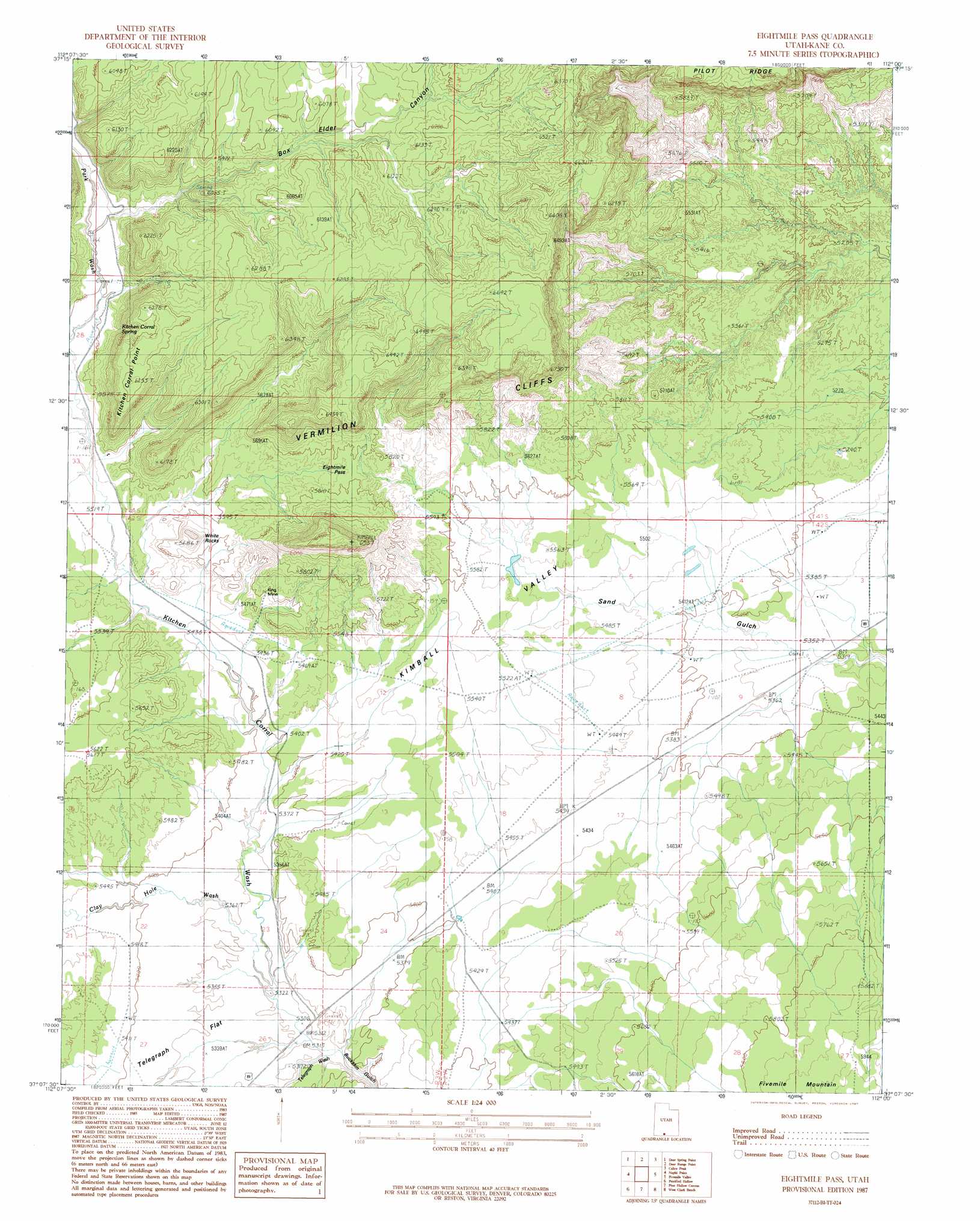
USGS Topo Quad 37112b1 - 1:24,000 scale
| Topo Map Name: | Eightmile Pass |
| USGS Topo Quad ID: | 37112b1 |
| Print Size: | ca. 21 1/4" wide x 27" high |
| Southeast Coordinates: | 37.125° N latitude / 112° W longitude |
| Map Center Coordinates: | 37.1875° N latitude / 112.0625° W longitude |
| U.S. State: | UT |
| Filename: | o37112b1.jpg |
| Download Map JPG Image: | Eightmile Pass topo map 1:24,000 scale |
| Map Type: | Topographic |
| Topo Series: | 7.5´ |
| Map Scale: | 1:24,000 |
| Source of Map Images: | United States Geological Survey (USGS) |
| Alternate Map Versions: |
Buckskin Gulch NE UT 1954 Download PDF Buy paper map Eightmile Pass UT 1987, updated 1987 Download PDF Buy paper map Eightmile Pass UT 2011 Download PDF Buy paper map Eightmile Pass UT 2014 Download PDF Buy paper map |
1:24,000 Topo Quads surrounding Eightmile Pass
Podunk Creek |
Rainbow Point |
Bull Valley Gorge |
Slickrock Bench |
Butler Valley |
Skutumpah Creek |
Deer Spring Point |
Deer Range Point |
Calico Peak |
Horse Flat |
Pine Point |
Nephi Point |
Eightmile Pass |
Fivemile Valley |
Lower Coyote Spring |
Johnson Lakes |
Petrified Hollow |
Pine Hollow Canyon |
West Clark Bench |
Bridger Point |
Muggins Flat |
Buck Pasture Canyon |
Coyote Buttes |
Poverty Flat |
Wrather Arch |
> Back to 37112a1 at 1:100,000 scale
> Back to 37112a1 at 1:250,000 scale
> Back to U.S. Topo Maps home
Eightmile Pass topo map: Gazetteer
Eightmile Pass: Capes
Kitchen Corral Point elevation 1903m 6243′Eightmile Pass: Flats
Telegraph Flat elevation 1636m 5367′Eightmile Pass: Gaps
Eight Mile Pass elevation 1758m 5767′Eightmile Pass elevation 1757m 5764′
Eightmile Pass: Mines
King Mine elevation 1692m 5551′Eightmile Pass: Ranges
Deer Range elevation 1845m 6053′Eightmile Pass: Springs
Kitchen Corral Spring elevation 1716m 5629′Eightmile Pass: Summits
White Rocks elevation 1701m 5580′Eightmile Pass: Valleys
Box Elder Canyon elevation 1710m 5610′Clay Hole Wash elevation 1622m 5321′
Deer Spring Wash elevation 1684m 5524′
Kimball Valley elevation 1644m 5393′
Kitchen Corral Wash elevation 1622m 5321′
Park Wash elevation 1683m 5521′
Telegraph Wash elevation 1620m 5314′
Eightmile Pass digital topo map on disk
Buy this Eightmile Pass topo map showing relief, roads, GPS coordinates and other geographical features, as a high-resolution digital map file on DVD: