Bald Knoll Topo Map Utah
To zoom in, hover over the map of Bald Knoll
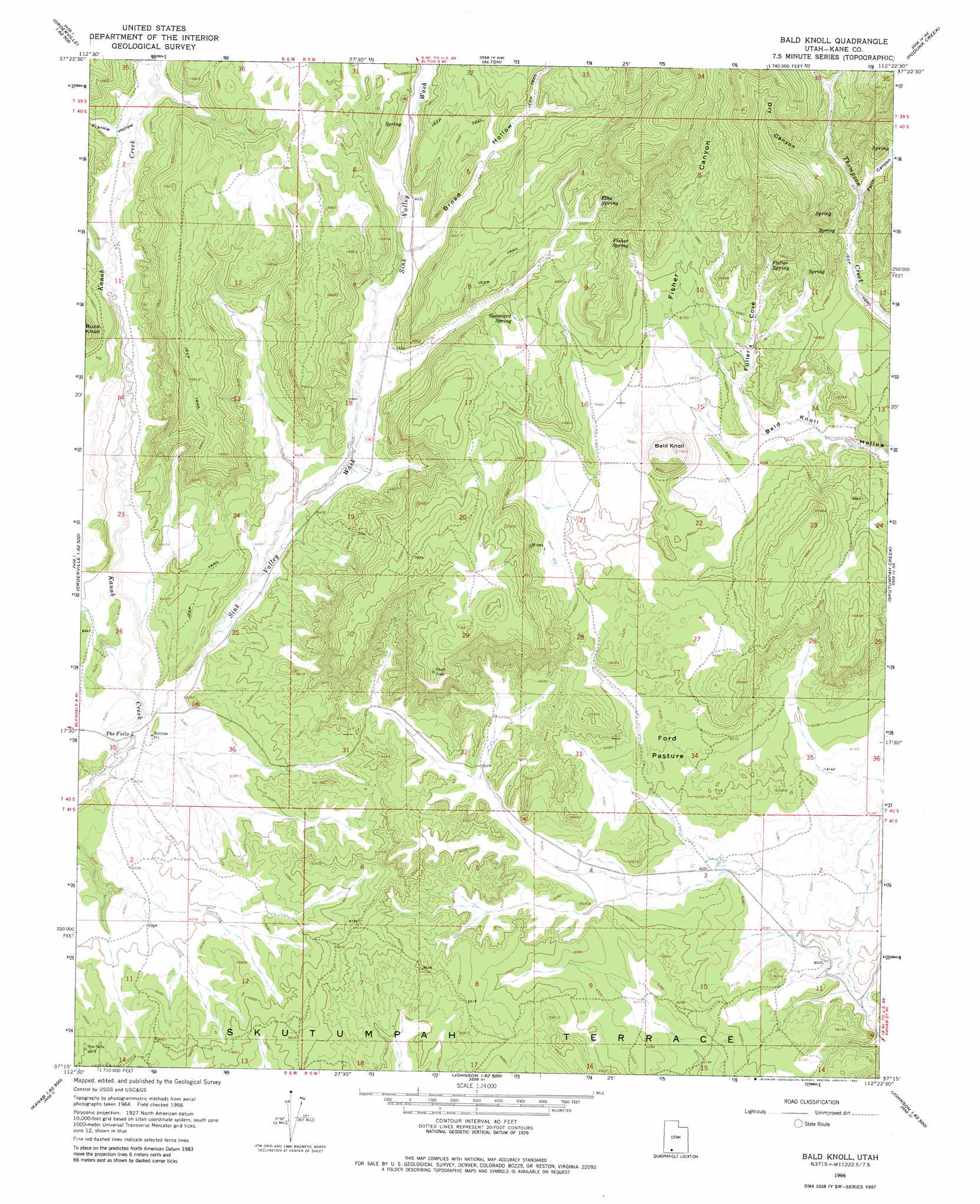
USGS Topo Quad 37112c4 - 1:24,000 scale
| Topo Map Name: | Bald Knoll |
| USGS Topo Quad ID: | 37112c4 |
| Print Size: | ca. 21 1/4" wide x 27" high |
| Southeast Coordinates: | 37.25° N latitude / 112.375° W longitude |
| Map Center Coordinates: | 37.3125° N latitude / 112.4375° W longitude |
| U.S. State: | UT |
| Filename: | o37112c4.jpg |
| Download Map JPG Image: | Bald Knoll topo map 1:24,000 scale |
| Map Type: | Topographic |
| Topo Series: | 7.5´ |
| Map Scale: | 1:24,000 |
| Source of Map Images: | United States Geological Survey (USGS) |
| Alternate Map Versions: |
Bald Knoll UT 1966, updated 1968 Download PDF Buy paper map Bald Knoll UT 1966, updated 1980 Download PDF Buy paper map Bald Knoll UT 2011 Download PDF Buy paper map Bald Knoll UT 2014 Download PDF Buy paper map |
1:24,000 Topo Quads surrounding Bald Knoll
Henrie Knolls |
Asay Bench |
George Mountain |
Tropic Reservoir |
Bryce Point |
Strawberry Point |
Long Valley Junction |
Alton |
Podunk Creek |
Rainbow Point |
Orderville |
Glendale |
Bald Knoll |
Skutumpah Creek |
Deer Spring Point |
Mount Carmel |
White Tower |
Cutler Point |
Pine Point |
Nephi Point |
Yellowjacket Canyon |
Kanab |
Thompson Point |
Johnson Lakes |
Petrified Hollow |
> Back to 37112a1 at 1:100,000 scale
> Back to 37112a1 at 1:250,000 scale
> Back to U.S. Topo Maps home
Bald Knoll topo map: Gazetteer
Bald Knoll: Bays
Fuller Cove elevation 1979m 6492′Bald Knoll: Falls
The Falls elevation 1891m 6204′Bald Knoll: Flats
Ford Pasture elevation 1915m 6282′Bald Knoll: Springs
Elbo Spring elevation 2122m 6961′Fisher Spring elevation 2108m 6916′
Fuller Spring elevation 2059m 6755′
Spaniard Spring elevation 2085m 6840′
Bald Knoll: Summits
Bald Knoll elevation 2132m 6994′Bald Knoll: Valleys
Broad Hollow elevation 2022m 6633′Dry Canyon elevation 2109m 6919′
Farm Canyon elevation 2073m 6801′
Fisher Canyon elevation 2049m 6722′
Frankie Hollow elevation 1989m 6525′
Sink Valley elevation 2057m 6748′
Sink Valley Wash elevation 1901m 6236′
Tater Canyon elevation 2173m 7129′
Bald Knoll digital topo map on disk
Buy this Bald Knoll topo map showing relief, roads, GPS coordinates and other geographical features, as a high-resolution digital map file on DVD: