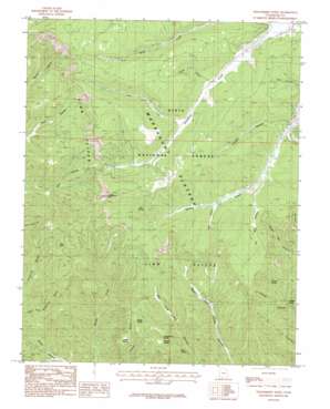
Strawberry Point Topo Map Utah
To zoom in, hover over the map of Strawberry Point
USGS Topo Quad 37112d6 - 1:24,000 scale
| Topo Map Name: | Strawberry Point |
| USGS Topo Quad ID: | 37112d6 |
| Print Size: | ca. 21 1/4" wide x 27" high |
| Southeast Coordinates: | 37.375° N latitude / 112.625° W longitude |
| Map Center Coordinates: | 37.4375° N latitude / 112.6875° W longitude |
| U.S. State: | UT |
| Filename: | o37112d6.jpg |
| Download Map JPG Image: | Strawberry Point topo map 1:24,000 scale |
| Map Type: | Topographic |
| Topo Series: | 7.5´ |
| Map Scale: | 1:24,000 |
| Source of Map Images: | United States Geological Survey (USGS) |
| Alternate Map Versions: |
Strawberry Point UT 1985, updated 1985 Download PDF Buy paper map Strawberry Point UT 2002, updated 2005 Download PDF Buy paper map Strawberry Point UT 2011 Download PDF Buy paper map Strawberry Point UT 2014 Download PDF Buy paper map |
| FStopo: | US Forest Service topo Strawberry Point is available: Download FStopo PDF Download FStopo TIF |
1:24,000 Topo Quads surrounding Strawberry Point
> Back to 37112a1 at 1:100,000 scale
> Back to 37112a1 at 1:250,000 scale
> Back to U.S. Topo Maps home
Strawberry Point topo map: Gazetteer
Strawberry Point: Basins
Round Valley elevation 2333m 7654′Strawberry Point: Benches
Cougar Bench elevation 2336m 7664′Strawberry Point: Capes
Strawberry Point elevation 2723m 8933′Strawberry Point: Springs
Birch Spring elevation 2167m 7109′Chokecherry Spring elevation 2290m 7513′
Currant Spring elevation 2324m 7624′
Deer Spring elevation 2245m 7365′
Hidden Spring elevation 2157m 7076′
Trough Spring elevation 2371m 7778′
Twin Springs elevation 2522m 8274′
Strawberry Point: Streams
Lars Fork elevation 2509m 8231′Willis Creek elevation 2466m 8090′
Strawberry Point: Summits
Pine Knoll elevation 2600m 8530′Strawberry Point: Valleys
Adair Hollow elevation 2425m 7956′Broad Hollow elevation 2508m 8228′
Everett Hollow elevation 2385m 7824′
Tar Kiln Hollow elevation 2403m 7883′
Strawberry Point digital topo map on disk
Buy this Strawberry Point topo map showing relief, roads, GPS coordinates and other geographical features, as a high-resolution digital map file on DVD:


