Washington Dome Topo Map Utah
To zoom in, hover over the map of Washington Dome
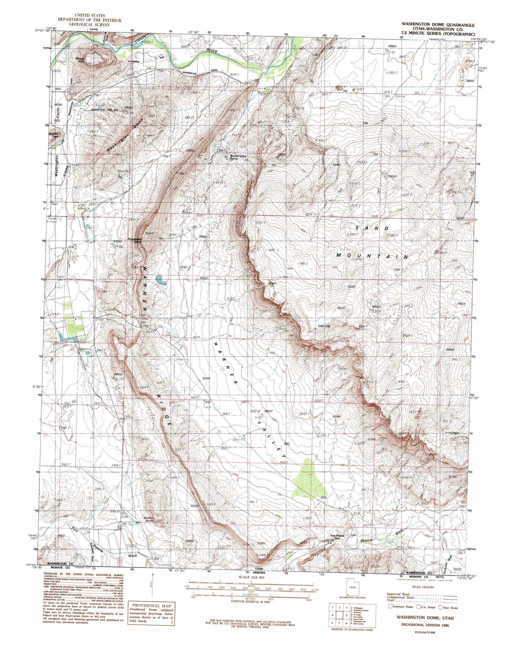
USGS Topo Quad 37113a4 - 1:24,000 scale
| Topo Map Name: | Washington Dome |
| USGS Topo Quad ID: | 37113a4 |
| Print Size: | ca. 21 1/4" wide x 27" high |
| Southeast Coordinates: | 37° N latitude / 113.375° W longitude |
| Map Center Coordinates: | 37.0625° N latitude / 113.4375° W longitude |
| U.S. State: | UT |
| Filename: | o37113a4.jpg |
| Download Map JPG Image: | Washington Dome topo map 1:24,000 scale |
| Map Type: | Topographic |
| Topo Series: | 7.5´ |
| Map Scale: | 1:24,000 |
| Source of Map Images: | United States Geological Survey (USGS) |
| Alternate Map Versions: |
La Verkin 3 SW UT 1954, updated 1956 Download PDF Buy paper map Washington Dome UT 1986, updated 1987 Download PDF Buy paper map Washington Dome UT 2011 Download PDF Buy paper map Washington Dome UT 2014 Download PDF Buy paper map |
1:24,000 Topo Quads surrounding Washington Dome
Veyo |
Saddle Mountain |
Signal Peak |
Pintura |
Smith Mesa |
Santa Clara |
Washington |
Harrisburg Junction |
Hurricane |
Virgin |
White Hills |
Saint George |
Washington Dome |
The Divide |
Little Creek Mountain |
Purgatory Canyon |
Lizard Point |
Yellowhorse Flat |
Rock Canyon |
Lost Spring Mountain West |
Wolf Hole Mountain West |
Wolf Hole Mountain East |
Hole-N-Wall Canyon |
Gyp Pocket |
White Pockets |
> Back to 37113a1 at 1:100,000 scale
> Back to 37112a1 at 1:250,000 scale
> Back to U.S. Topo Maps home
Washington Dome topo map: Gazetteer
Washington Dome: Basins
Warner Valley elevation 941m 3087′Washington Dome: Canals
Saint George and Washington Canal elevation 814m 2670′Washington Dome: Dams
Gypsum Wash Debris Basin Dam elevation 831m 2726′Stucki Debris Basin Dam elevation 848m 2782′
Warner Draw Debris Basin Dam elevation 909m 2982′
Washington Dome: Reservoirs
Gypsum Wash Debris Basin Reservoir elevation 831m 2726′Stucki Debris Basin Reservoir elevation 848m 2782′
Warner Draw Debris Basin Reservoir elevation 909m 2982′
Washington Dome: Ridges
Warner Ridge elevation 1076m 3530′Washington Dome: Springs
Warner Valley Spring elevation 883m 2896′Washington Dome: Summits
Beehive Dome elevation 947m 3106′Little Black Mountain elevation 920m 3018′
Punchbowl Dome elevation 1077m 3533′
Sand Mountain elevation 1221m 4005′
Shinob Kibe elevation 984m 3228′
Washington Dome elevation 994m 3261′
Washington Dome: Valleys
Dutchman Draw elevation 842m 2762′Grapevine Pass Wash elevation 800m 2624′
Hurricane Wash elevation 920m 3018′
Washington Dome digital topo map on disk
Buy this Washington Dome topo map showing relief, roads, GPS coordinates and other geographical features, as a high-resolution digital map file on DVD: