Hurricane Topo Map Utah
To zoom in, hover over the map of Hurricane
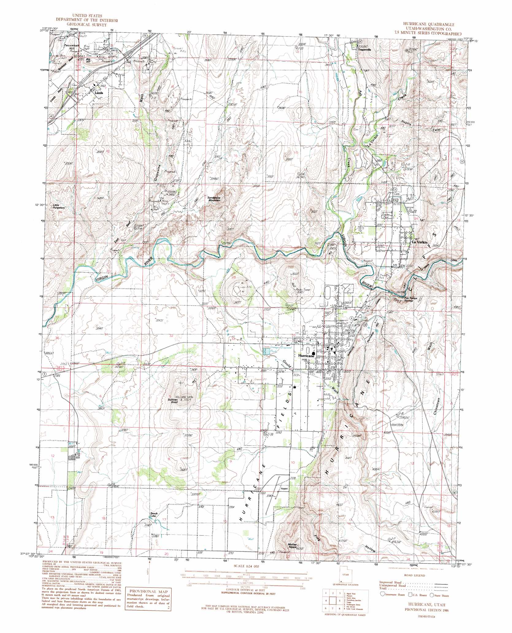
USGS Topo Quad 37113b3 - 1:24,000 scale
| Topo Map Name: | Hurricane |
| USGS Topo Quad ID: | 37113b3 |
| Print Size: | ca. 21 1/4" wide x 27" high |
| Southeast Coordinates: | 37.125° N latitude / 113.25° W longitude |
| Map Center Coordinates: | 37.1875° N latitude / 113.3125° W longitude |
| U.S. State: | UT |
| Filename: | o37113b3.jpg |
| Download Map JPG Image: | Hurricane topo map 1:24,000 scale |
| Map Type: | Topographic |
| Topo Series: | 7.5´ |
| Map Scale: | 1:24,000 |
| Source of Map Images: | United States Geological Survey (USGS) |
| Alternate Map Versions: |
La Verkin 3 NE UT 1954, updated 1956 Download PDF Buy paper map Hurricane UT 1986, updated 1987 Download PDF Buy paper map Hurricane UT 2011 Download PDF Buy paper map Hurricane UT 2014 Download PDF Buy paper map |
1:24,000 Topo Quads surrounding Hurricane
Central East |
Grass Valley |
New Harmony |
Kolob Arch |
Kolob Reservoir |
Saddle Mountain |
Signal Peak |
Pintura |
Smith Mesa |
The Guardian Angels |
Washington |
Harrisburg Junction |
Hurricane |
Virgin |
Springdale West |
Saint George |
Washington Dome |
The Divide |
Little Creek Mountain |
Smithsonian Butte |
Lizard Point |
Yellowhorse Flat |
Rock Canyon |
Lost Spring Mountain West |
Lost Spring Mountain East |
> Back to 37113a1 at 1:100,000 scale
> Back to 37112a1 at 1:250,000 scale
> Back to U.S. Topo Maps home
Hurricane topo map: Gazetteer
Hurricane: Airports
Hurricane Airport elevation 1019m 3343′Hurricane: Areas
Hurricane Fields elevation 1008m 3307′Little Purgatory elevation 1025m 3362′
Hurricane: Canals
Hurricane Canal elevation 1054m 3458′La Verkin Canal elevation 1003m 3290′
Leeds Ditch elevation 1060m 3477′
Hurricane: Lakes
Bench Lake elevation 1004m 3293′Hurricane: Mines
Doyle Shaft elevation 1108m 3635′Vanderbilt Mine elevation 1101m 3612′
Hurricane: Parks
Gateway Trailer Park elevation 984m 3228′Kimball Motel and RV Park elevation 1075m 3526′
Quail Lake RV Park elevation 994m 3261′
Roberts Roost elevation 992m 3254′
Hurricane: Populated Places
Hurricane elevation 990m 3248′LaVerkin elevation 973m 3192′
Leeds elevation 1061m 3480′
Virgin Territory Trailer Park elevation 981m 3218′
Hurricane: Post Offices
Hurricane Post Office elevation 989m 3244′La Verkin Post Office elevation 975m 3198′
Hurricane: Ridges
Buckeye Reef elevation 1153m 3782′East Reef elevation 922m 3024′
Hurricane: Springs
Dixie Hot Springs elevation 944m 3097′Hurricane: Streams
Ash Creek elevation 909m 2982′La Verkin Creek elevation 910m 2985′
Wet Sandy elevation 1013m 3323′
Hurricane: Summits
Big Hill elevation 1139m 3736′Hurricane Hill elevation 1073m 3520′
Mollies Nipple elevation 1400m 4593′
Sandstone Mountain elevation 1140m 3740′
Sullivan Knoll elevation 1224m 4015′
Tecumseh Hill elevation 1151m 3776′
Hurricane: Valleys
Chinatown Wash elevation 952m 3123′Frog Hollow elevation 1049m 3441′
Gould Wash elevation 878m 2880′
Grapevine Wash elevation 868m 2847′
Nephis Twist elevation 963m 3159′
Workman Wash elevation 1243m 4078′
Hurricane digital topo map on disk
Buy this Hurricane topo map showing relief, roads, GPS coordinates and other geographical features, as a high-resolution digital map file on DVD: