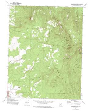
Saddle Mountain Topo Map Utah
To zoom in, hover over the map of Saddle Mountain
USGS Topo Quad 37113c5 - 1:24,000 scale
| Topo Map Name: | Saddle Mountain |
| USGS Topo Quad ID: | 37113c5 |
| Print Size: | ca. 21 1/4" wide x 27" high |
| Southeast Coordinates: | 37.25° N latitude / 113.5° W longitude |
| Map Center Coordinates: | 37.3125° N latitude / 113.5625° W longitude |
| U.S. State: | UT |
| Filename: | o37113c5.jpg |
| Download Map JPG Image: | Saddle Mountain topo map 1:24,000 scale |
| Map Type: | Topographic |
| Topo Series: | 7.5´ |
| Map Scale: | 1:24,000 |
| Source of Map Images: | United States Geological Survey (USGS) |
| Alternate Map Versions: |
Saddle Mountain UT 1972, updated 1976 Download PDF Buy paper map Saddle Mountain UT 2002, updated 2005 Download PDF Buy paper map Saddle Mountain UT 2011 Download PDF Buy paper map Saddle Mountain UT 2014 Download PDF Buy paper map |
| FStopo: | US Forest Service topo Saddle Mountain is available: Download FStopo PDF Download FStopo TIF |
1:24,000 Topo Quads surrounding Saddle Mountain
> Back to 37113a1 at 1:100,000 scale
> Back to 37112a1 at 1:250,000 scale
> Back to U.S. Topo Maps home
Saddle Mountain topo map: Gazetteer
Saddle Mountain: Basins
Diamond Valley elevation 1383m 4537′Saddle Mountain: Benches
Truman Bench elevation 2194m 7198′Saddle Mountain: Springs
Big Pine Spring elevation 2257m 7404′Carter Canyon Spring elevation 2243m 7358′
Cottonwood Spring elevation 2203m 7227′
Cougar Spring elevation 1807m 5928′
East Fork Spring elevation 1856m 6089′
Goat Spring elevation 2168m 7112′
Lower Spring elevation 1870m 6135′
Maudsley Spring elevation 1734m 5688′
Mud Spring elevation 2232m 7322′
Quaking Aspen Spring elevation 2289m 7509′
Slide Canyon Spring elevation 2253m 7391′
West Fork Spring elevation 2000m 6561′
Saddle Mountain: Streams
East Fork Cottonwood Creek elevation 1681m 5515′Middle Fork Cottonwood Creek elevation 1731m 5679′
West Fork Cottonwood Creek elevation 1681m 5515′
Saddle Mountain: Summits
Burger Peak elevation 3130m 10269′Cedar Knoll elevation 1875m 6151′
Cedar Knoll elevation 2056m 6745′
Grass Knoll elevation 2224m 7296′
Mahogany Knoll elevation 2112m 6929′
Red Knoll elevation 2129m 6984′
Saddle Mountain elevation 2770m 9087′
Saddle Mountain: Trails
Goat Spring Trail elevation 2178m 7145′Indian Hollow Spring Trail elevation 2242m 7355′
Summit Trail elevation 2169m 7116′
Saddle Mountain: Valleys
Alger Gulch elevation 1453m 4767′Carter Canyon elevation 1905m 6250′
Goat Canyon elevation 1966m 6450′
Lone Pine Canyon elevation 2117m 6945′
Reservoir Canyon elevation 2063m 6768′
Rock Canyon elevation 2074m 6804′
Rock Hollow Wash elevation 1392m 4566′
Slide Canyon elevation 2150m 7053′
Saddle Mountain digital topo map on disk
Buy this Saddle Mountain topo map showing relief, roads, GPS coordinates and other geographical features, as a high-resolution digital map file on DVD:


