Gunlock Topo Map Utah
To zoom in, hover over the map of Gunlock
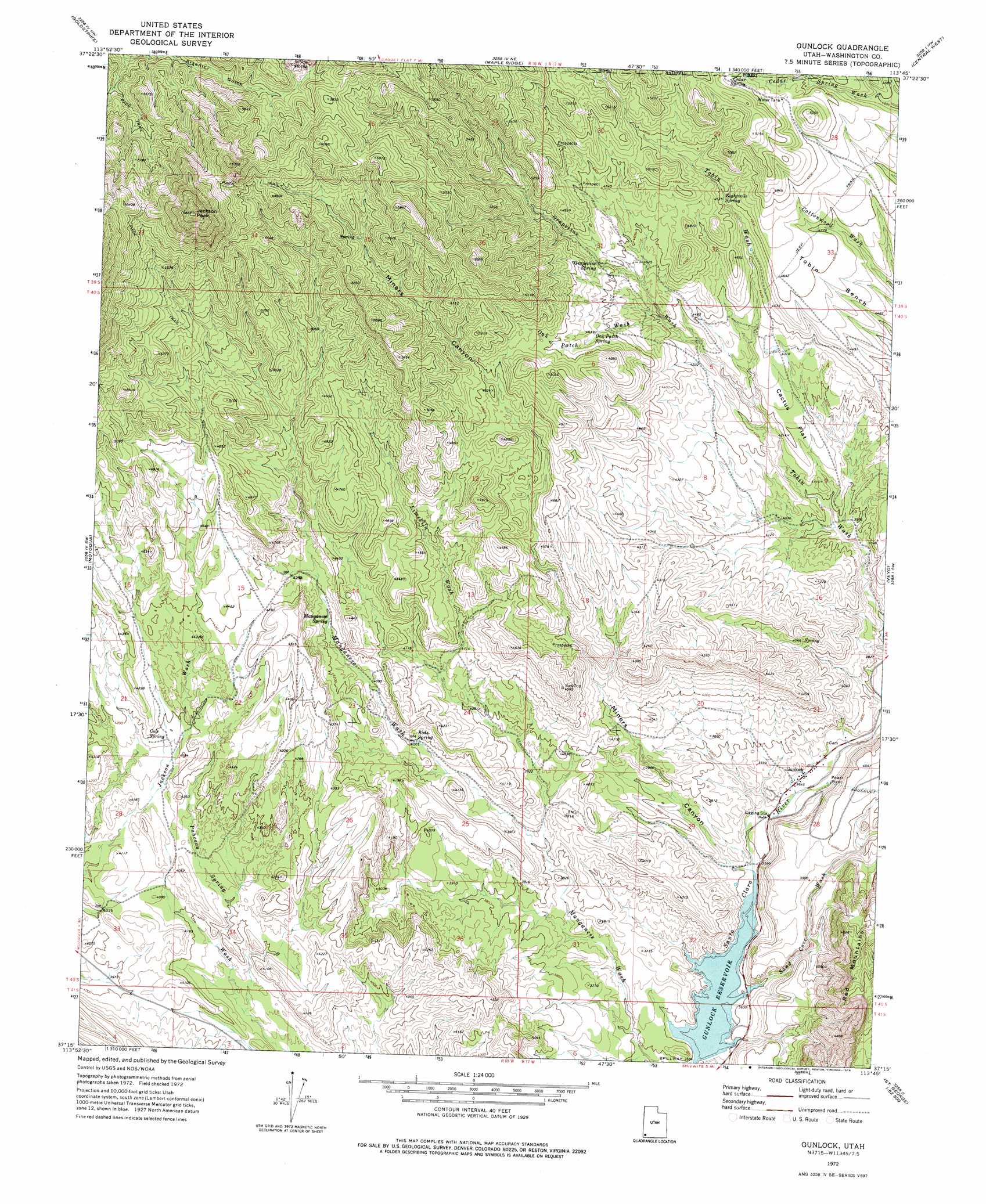
USGS Topo Quad 37113c7 - 1:24,000 scale
| Topo Map Name: | Gunlock |
| USGS Topo Quad ID: | 37113c7 |
| Print Size: | ca. 21 1/4" wide x 27" high |
| Southeast Coordinates: | 37.25° N latitude / 113.75° W longitude |
| Map Center Coordinates: | 37.3125° N latitude / 113.8125° W longitude |
| U.S. State: | UT |
| Filename: | o37113c7.jpg |
| Download Map JPG Image: | Gunlock topo map 1:24,000 scale |
| Map Type: | Topographic |
| Topo Series: | 7.5´ |
| Map Scale: | 1:24,000 |
| Source of Map Images: | United States Geological Survey (USGS) |
| Alternate Map Versions: |
Gunlock UT 1954, updated 1956 Download PDF Buy paper map Gunlock UT 1972, updated 1976 Download PDF Buy paper map Gunlock UT 2002, updated 2005 Download PDF Buy paper map Gunlock UT 2011 Download PDF Buy paper map Gunlock UT 2014 Download PDF Buy paper map |
| FStopo: | US Forest Service topo Gunlock is available: Download FStopo PDF Download FStopo TIF |
1:24,000 Topo Quads surrounding Gunlock
Pine Park |
Water Canyon Peak |
Hebron |
Enterprise |
Pinto |
Docs Pass |
Goldstrike |
Maple Ridge |
Central West |
Central East |
Dodge Spring |
Motoqua |
Gunlock |
Veyo |
Saddle Mountain |
Scarecrow Peak |
West Mountain Peak |
Shivwits |
Santa Clara |
Washington |
Terry Benches |
Castle Cliff |
Jarvis Peak |
White Hills |
Saint George |
> Back to 37113a1 at 1:100,000 scale
> Back to 37112a1 at 1:250,000 scale
> Back to U.S. Topo Maps home
Gunlock topo map: Gazetteer
Gunlock: Benches
Tobin Bench elevation 1369m 4491′Gunlock: Flats
Cactus Flat elevation 1282m 4206′Gunlock: Parks
Gunlock State Park elevation 1102m 3615′Gunlock: Populated Places
Gunlock elevation 1115m 3658′Gunlock: Reservoirs
Gunlock Reservoir elevation 1086m 3562′Gunlock: Springs
Cedar Spring elevation 1511m 4957′Cole Spring elevation 1280m 4199′
Eightmile Spring elevation 1390m 4560′
Grapevine Spring elevation 1403m 4603′
Intermittent Spring elevation 1360m 4461′
Manganese Spring elevation 1280m 4199′
Oak Patch Spring elevation 1416m 4645′
Rods Spring elevation 1219m 3999′
Gunlock: Summits
Jackson Peak elevation 2072m 6797′Gunlock: Valleys
Grapevine Wash elevation 1269m 4163′Limekiln Wash elevation 1155m 3789′
Miners Canyon elevation 1097m 3599′
Oak Patch Wash elevation 1327m 4353′
Sand Cove Wash elevation 1095m 3592′
Gunlock digital topo map on disk
Buy this Gunlock topo map showing relief, roads, GPS coordinates and other geographical features, as a high-resolution digital map file on DVD: