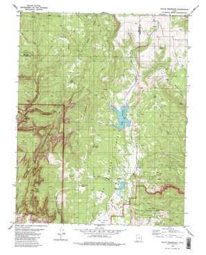
Kolob Reservoir Topo Map Utah
To zoom in, hover over the map of Kolob Reservoir
USGS Topo Quad 37113d1 - 1:24,000 scale
| Topo Map Name: | Kolob Reservoir |
| USGS Topo Quad ID: | 37113d1 |
| Print Size: | ca. 21 1/4" wide x 27" high |
| Southeast Coordinates: | 37.375° N latitude / 113° W longitude |
| Map Center Coordinates: | 37.4375° N latitude / 113.0625° W longitude |
| U.S. State: | UT |
| Filename: | o37113d1.jpg |
| Download Map JPG Image: | Kolob Reservoir topo map 1:24,000 scale |
| Map Type: | Topographic |
| Topo Series: | 7.5´ |
| Map Scale: | 1:24,000 |
| Source of Map Images: | United States Geological Survey (USGS) |
| Alternate Map Versions: |
Kolob Reservoir UT 1980, updated 1981 Download PDF Buy paper map Kolob Reservoir UT 1980, updated 1981 Download PDF Buy paper map Kolob Reservoir UT 2011 Download PDF Buy paper map Kolob Reservoir UT 2014 Download PDF Buy paper map |
1:24,000 Topo Quads surrounding Kolob Reservoir
> Back to 37113a1 at 1:100,000 scale
> Back to 37112a1 at 1:250,000 scale
> Back to U.S. Topo Maps home
Kolob Reservoir topo map: Gazetteer
Kolob Reservoir: Canals
Spring Creek Ditch elevation 2487m 8159′Kolob Reservoir: Capes
Hornet Point elevation 2852m 9356′Lava Point elevation 2368m 7769′
Long Point elevation 2171m 7122′
Kolob Reservoir: Dams
Blue Springs Reservoir Dam elevation 2416m 7926′Kolob Creek Dam elevation 2474m 8116′
Meadow Hollow Dam elevation 2550m 8366′
Kolob Reservoir: Flats
The Hardscrabble elevation 2417m 7929′Kolob Reservoir: Lakes
Chasm Lake elevation 2012m 6601′Kolob Reservoir: Plains
Lower Kolob Plateau elevation 2427m 7962′Upper Kolob Plateau elevation 2426m 7959′
Kolob Reservoir: Reservoirs
Blue Springs Reservoir elevation 2415m 7923′Kolob Creek Reservoir elevation 2474m 8116′
Kolob Reservoir elevation 2471m 8106′
Meadow Hollow Reservoir elevation 2550m 8366′
Kolob Reservoir: Ridges
The Pillars elevation 2562m 8405′Kolob Reservoir: Springs
Birch Spring elevation 2260m 7414′Blue Springs elevation 2424m 7952′
House Spring elevation 2729m 8953′
Mud Spring elevation 2255m 7398′
Oak Spring elevation 2353m 7719′
Kolob Reservoir: Streams
Bear Creek elevation 2415m 7923′Willis Creek elevation 1823m 5980′
Willow Creek elevation 2161m 7089′
Kolob Reservoir: Summits
Bullpen Mountain elevation 2150m 7053′Goose Creek Knoll elevation 2302m 7552′
Home Valley Knoll elevation 2492m 8175′
Kolob Peak elevation 2726m 8943′
Langston Mountain elevation 2266m 7434′
Little Creek Peak elevation 2661m 8730′
Kolob Reservoir: Valleys
Bear Canyon elevation 1894m 6213′Bear Trap Canyon elevation 1759m 5770′
Bear Valley elevation 2437m 7995′
Beebe Hollow elevation 2473m 8113′
Indian Hollow elevation 2473m 8113′
Meadow Hollow elevation 2531m 8303′
Pine Hollow elevation 2148m 7047′
Kolob Reservoir digital topo map on disk
Buy this Kolob Reservoir topo map showing relief, roads, GPS coordinates and other geographical features, as a high-resolution digital map file on DVD:


