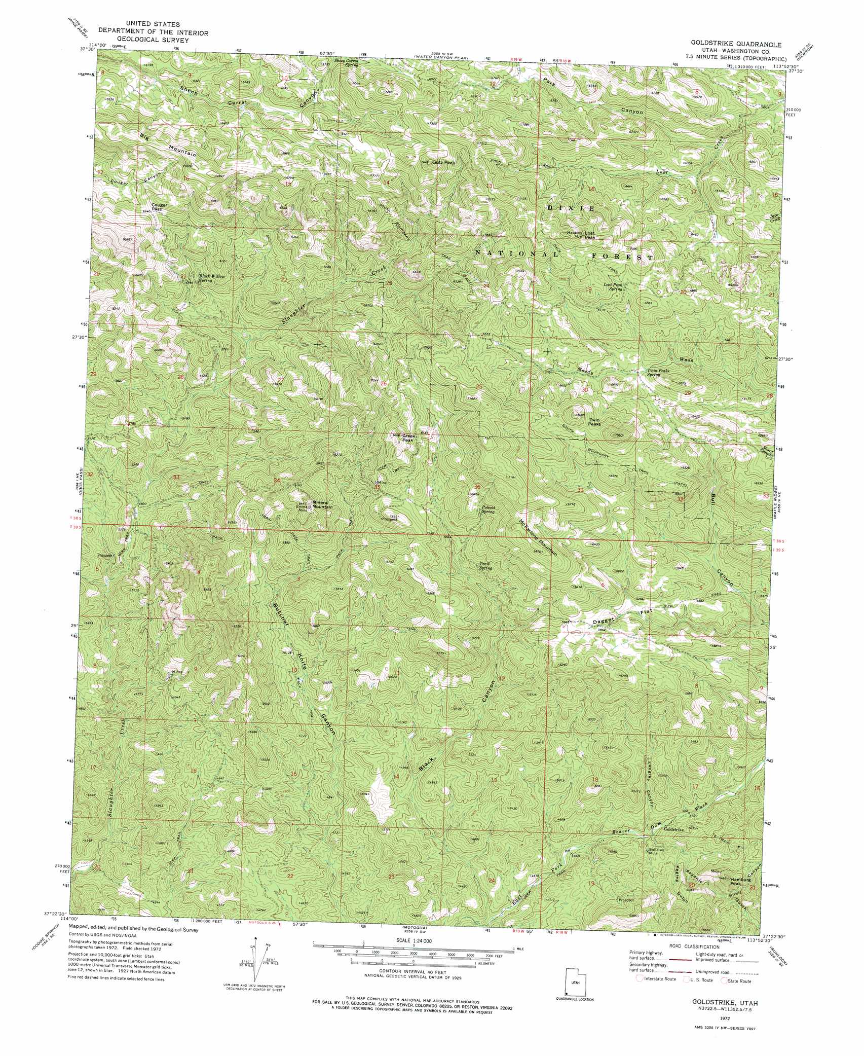
Goldstrike Topo Map Utah
To zoom in, hover over the map of Goldstrike
USGS Topo Quad 37113d8 - 1:24,000 scale
| Topo Map Name: | Goldstrike |
| USGS Topo Quad ID: | 37113d8 |
| Print Size: | ca. 21 1/4" wide x 27" high |
| Southeast Coordinates: | 37.375° N latitude / 113.875° W longitude |
| Map Center Coordinates: | 37.4375° N latitude / 113.9375° W longitude |
| U.S. State: | UT |
| Filename: | o37113d8.jpg |
| Download Map JPG Image: | Goldstrike topo map 1:24,000 scale |
| Map Type: | Topographic |
| Topo Series: | 7.5´ |
| Map Scale: | 1:24,000 |
| Source of Map Images: | United States Geological Survey (USGS) |
| Alternate Map Versions: |
Goldstrike UT 1972, updated 1976 Download PDF Buy paper map Goldstrike UT 1972, updated 1988 Download PDF Buy paper map Goldstrike UT 1972, updated 1988 Download PDF Buy paper map Goldstrike UT 2002, updated 2005 Download PDF Buy paper map Goldstrike UT 2011 Download PDF Buy paper map Goldstrike UT 2014 Download PDF Buy paper map |
| FStopo: | US Forest Service topo Goldstrike is available: Download FStopo PDF Download FStopo TIF |
1:24,000 Topo Quads surrounding Goldstrike
Dow Mountain |
Uvada |
Mount Escalante |
Pinon Point |
Beryl Junction |
Acoma |
Pine Park |
Water Canyon Peak |
Hebron |
Enterprise |
Bunker Peak |
Docs Pass |
Goldstrike |
Maple Ridge |
Central West |
Jacks Mountain |
Dodge Spring |
Motoqua |
Gunlock |
Veyo |
Lime Mountain |
Scarecrow Peak |
West Mountain Peak |
Shivwits |
Santa Clara |
> Back to 37113a1 at 1:100,000 scale
> Back to 37112a1 at 1:250,000 scale
> Back to U.S. Topo Maps home
Goldstrike topo map: Gazetteer
Goldstrike: Flats
Dagget Flat elevation 1808m 5931′Goldstrike: Gaps
Cougar Pass elevation 1931m 6335′Goldstrike: Mines
Bull Run Mine elevation 1415m 4642′Emma Mine elevation 1935m 6348′
Goldstrike: Springs
Aspen Spring elevation 2030m 6660′Black Willow Spring elevation 1723m 5652′
Lost Peak Spring elevation 2040m 6692′
Polecat Spring elevation 1889m 6197′
Trail Spring elevation 1766m 5793′
Twin Peaks Spring elevation 1902m 6240′
Goldstrike: Summits
Big Mountain elevation 2139m 7017′Greek Peak elevation 2087m 6847′
Gutz Peak elevation 2265m 7431′
Hamburg Peak elevation 1651m 5416′
Lost Peak elevation 2287m 7503′
McFarlane Mountain elevation 2090m 6856′
Mineral Mountain elevation 1949m 6394′
Twin Peaks elevation 2151m 7057′
Goldstrike: Valleys
Arsenic Gulch elevation 1398m 4586′Black Canyon elevation 1321m 4333′
Longley Canyon elevation 1399m 4589′
Park Canyon elevation 1841m 6040′
Pegleg Gulch elevation 1439m 4721′
Quail Canyon elevation 1497m 4911′
Goldstrike digital topo map on disk
Buy this Goldstrike topo map showing relief, roads, GPS coordinates and other geographical features, as a high-resolution digital map file on DVD: