Stoddard Mountain Topo Map Utah
To zoom in, hover over the map of Stoddard Mountain
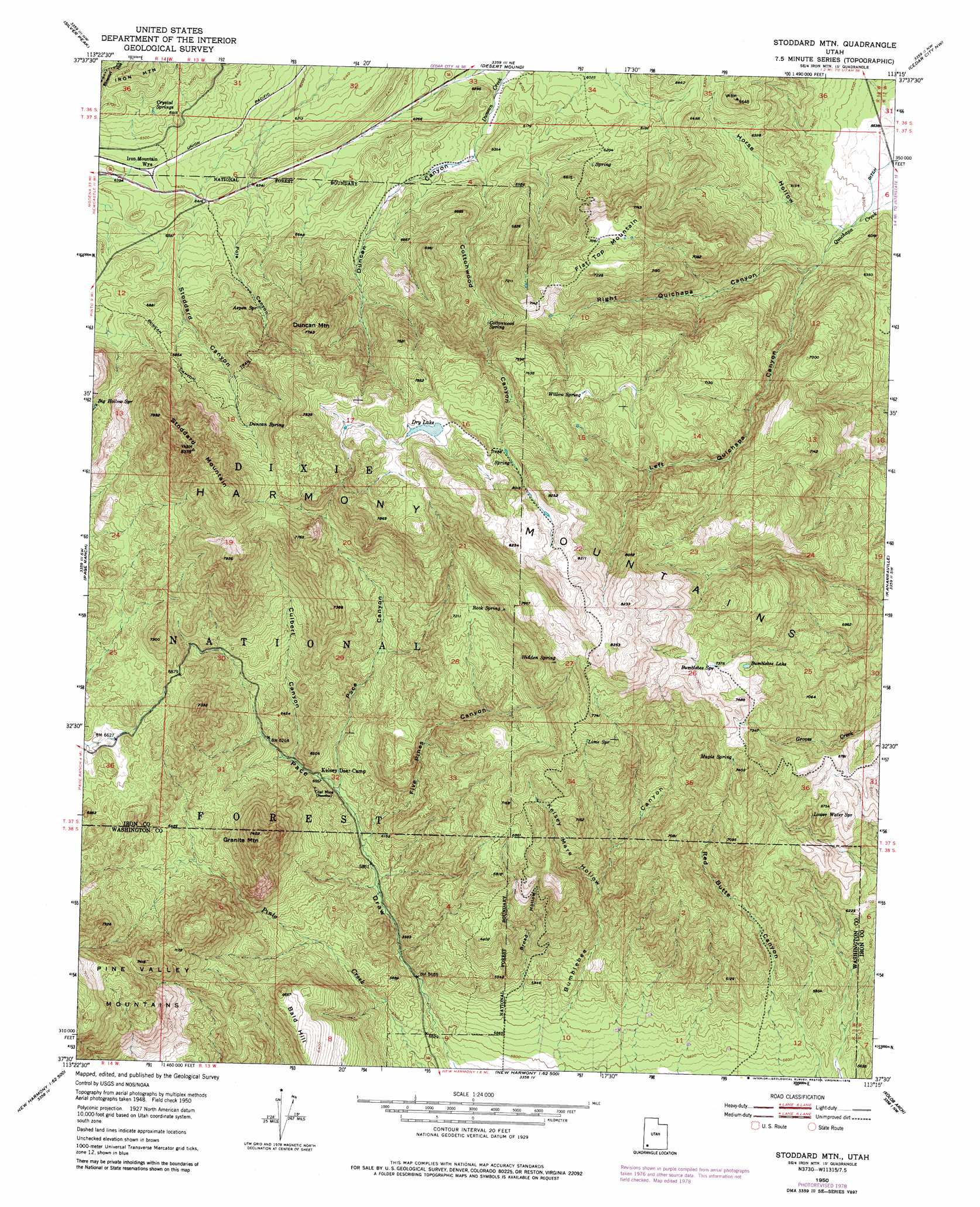
USGS Topo Quad 37113e3 - 1:24,000 scale
| Topo Map Name: | Stoddard Mountain |
| USGS Topo Quad ID: | 37113e3 |
| Print Size: | ca. 21 1/4" wide x 27" high |
| Southeast Coordinates: | 37.5° N latitude / 113.25° W longitude |
| Map Center Coordinates: | 37.5625° N latitude / 113.3125° W longitude |
| U.S. State: | UT |
| Filename: | o37113e3.jpg |
| Download Map JPG Image: | Stoddard Mountain topo map 1:24,000 scale |
| Map Type: | Topographic |
| Topo Series: | 7.5´ |
| Map Scale: | 1:24,000 |
| Source of Map Images: | United States Geological Survey (USGS) |
| Alternate Map Versions: |
Stoddard Mtn UT 1950, updated 1975 Download PDF Buy paper map Stoddard Mtn UT 1951 Download PDF Buy paper map Stoddard Mountain UT 2011 Download PDF Buy paper map Stoddard Mountain UT 2014 Download PDF Buy paper map |
| FStopo: | US Forest Service topo Stoddard Mountain is available: Download FStopo PDF Download FStopo TIF |
1:24,000 Topo Quads surrounding Stoddard Mountain
Clark Farm |
Antelope Peak |
Avon Se |
The Three Peaks |
Enoch |
Newcastle |
Silver Peak |
Desert Mound |
Cedar City Nw |
Cedar City |
Pinto |
Page Ranch |
Stoddard Mountain |
Kanarraville |
Cedar Mountain |
Central East |
Grass Valley |
New Harmony |
Kolob Arch |
Kolob Reservoir |
Saddle Mountain |
Signal Peak |
Pintura |
Smith Mesa |
The Guardian Angels |
> Back to 37113e1 at 1:100,000 scale
> Back to 37112a1 at 1:250,000 scale
> Back to U.S. Topo Maps home
Stoddard Mountain topo map: Gazetteer
Stoddard Mountain: Lakes
Bumblebee Lake elevation 2226m 7303′Dry Lake elevation 2345m 7693′
Stoddard Mountain: Ranges
Harmony Mountains elevation 2510m 8234′Stoddard Mountain: Springs
Aspen Spring elevation 2074m 6804′Bumblebee Spring elevation 2249m 7378′
Cottonwood Spring elevation 2067m 6781′
Crystal Springs elevation 2011m 6597′
Duncan Spring elevation 2202m 7224′
Hidden Spring elevation 2327m 7634′
Lime Spring elevation 2264m 7427′
Lower Water Spring elevation 1966m 6450′
Maple Spring elevation 2209m 7247′
Rock Spring elevation 2276m 7467′
Willow Spring elevation 2283m 7490′
Stoddard Mountain: Summits
Bald Hill elevation 2026m 6646′Duncan Mountain elevation 2348m 7703′
Flat Top Mountain elevation 2185m 7168′
Granite Mountain elevation 2257m 7404′
Stoddard Mountain elevation 2550m 8366′
Stoddard Mountain: Trails
Dry Lakes Trail elevation 2290m 7513′Duncan Canyon Trail elevation 2187m 7175′
Stoddard Mountain: Valleys
Broad Hollow elevation 1714m 5623′Cottonwood Canyon elevation 1902m 6240′
Culbert Canyon elevation 1877m 6158′
Duncan Canyon elevation 1889m 6197′
Five Pines Canyon elevation 1802m 5912′
Horse Hollow elevation 1766m 5793′
Kelsey Mare Hollow elevation 1852m 6076′
Left Quichapa Canyon elevation 1788m 5866′
Pace Canyon elevation 1832m 6010′
Pole Canyon elevation 1935m 6348′
Right Quichapa Canyon elevation 1785m 5856′
Stoddard Canyon elevation 1956m 6417′
Stoddard Mountain digital topo map on disk
Buy this Stoddard Mountain topo map showing relief, roads, GPS coordinates and other geographical features, as a high-resolution digital map file on DVD: