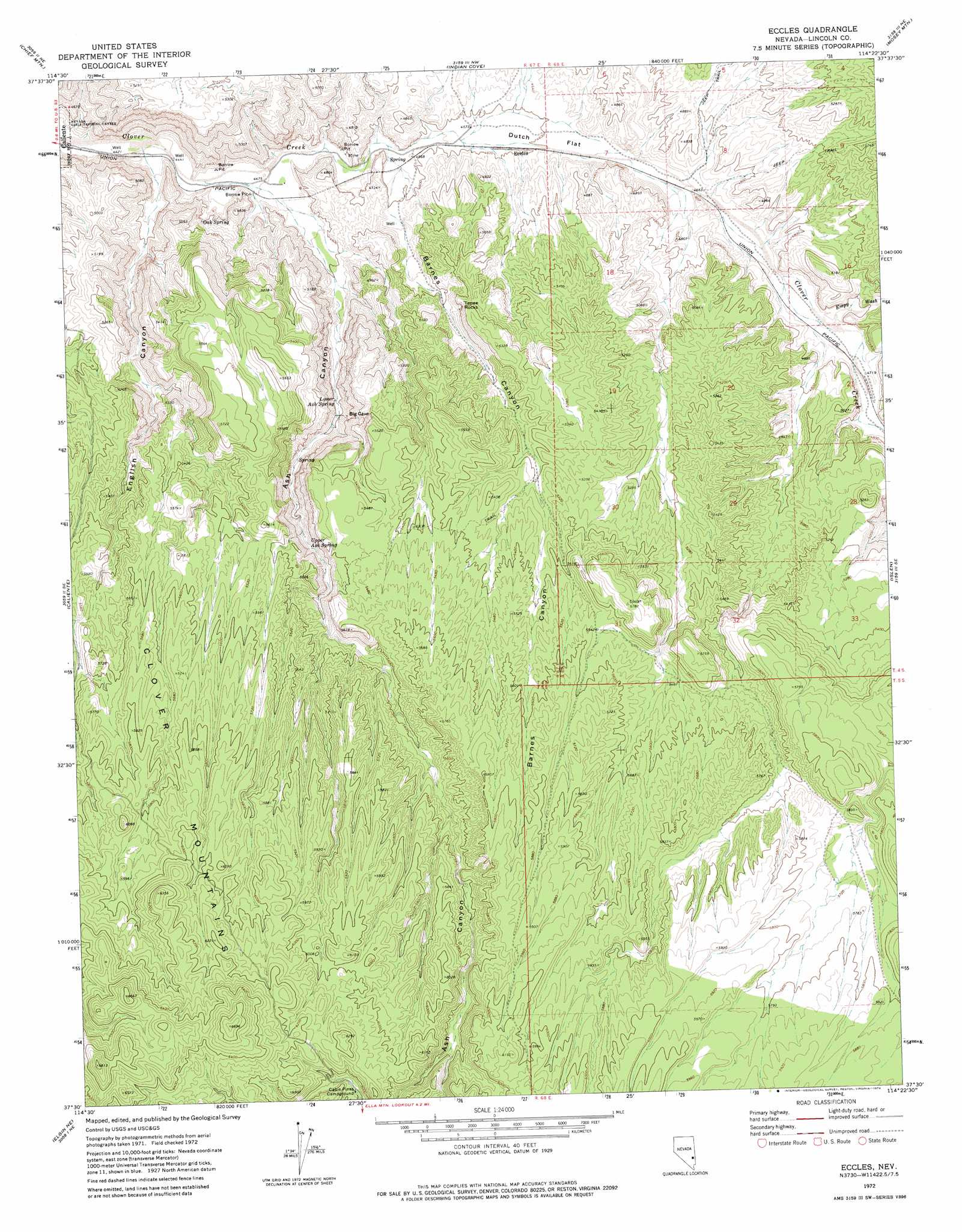
Eccles Topo Map Nevada
To zoom in, hover over the map of Eccles
USGS Topo Quad 37114e4 - 1:24,000 scale
| Topo Map Name: | Eccles |
| USGS Topo Quad ID: | 37114e4 |
| Print Size: | ca. 21 1/4" wide x 27" high |
| Southeast Coordinates: | 37.5° N latitude / 114.375° W longitude |
| Map Center Coordinates: | 37.5625° N latitude / 114.4375° W longitude |
| U.S. State: | NV |
| Filename: | o37114e4.jpg |
| Download Map JPG Image: | Eccles topo map 1:24,000 scale |
| Map Type: | Topographic |
| Topo Series: | 7.5´ |
| Map Scale: | 1:24,000 |
| Source of Map Images: | United States Geological Survey (USGS) |
| Alternate Map Versions: |
Eccles NV 1972, updated 1974 Download PDF Buy paper map Eccles NV 2012 Download PDF Buy paper map Eccles NV 2014 Download PDF Buy paper map |
1:24,000 Topo Quads surrounding Eccles
The Bluffs |
Bennett Pass |
Panaca |
Condor Canyon |
Panaca Summit |
Caliente Nw |
Chief Mountain |
Indian Cove |
Mosey Mountain |
Dow Mountain |
Chokecherry Mountain |
Caliente |
Eccles |
Islen |
Acoma |
Slidy Mountain |
Elgin Ne |
Ella Mountain |
Fife Mountain |
Bunker Peak |
Elgin Sw |
Elgin |
Leith |
Garden Spring |
Jacks Mountain |
> Back to 37114e1 at 1:100,000 scale
> Back to 37114a1 at 1:250,000 scale
> Back to U.S. Topo Maps home
Eccles topo map: Gazetteer
Eccles: Flats
Dutch Flat elevation 1408m 4619′Eccles: Mines
Eccles Mine elevation 1424m 4671′Minto Mine elevation 1440m 4724′
Eccles: Populated Places
Eccles elevation 1403m 4603′Eccles: Reservoirs
Eccles Reservoir elevation 1609m 5278′Lone Pine Reservoir elevation 1781m 5843′
Minto Reservoir elevation 1629m 5344′
Eccles: Springs
Lower Ash Spring elevation 1458m 4783′Oak Spring elevation 1427m 4681′
Upper Ash Spring elevation 1546m 5072′
Willow Spring elevation 1468m 4816′
Eccles: Streams
Empy Wash elevation 1435m 4708′Eccles: Summits
Tepee Rocks elevation 1591m 5219′Eccles: Valleys
Ash Canyon elevation 1379m 4524′Barnes Canyon elevation 1390m 4560′
English Canyon elevation 1355m 4445′
Eccles digital topo map on disk
Buy this Eccles topo map showing relief, roads, GPS coordinates and other geographical features, as a high-resolution digital map file on DVD: