Caliente Topo Map Nevada
To zoom in, hover over the map of Caliente
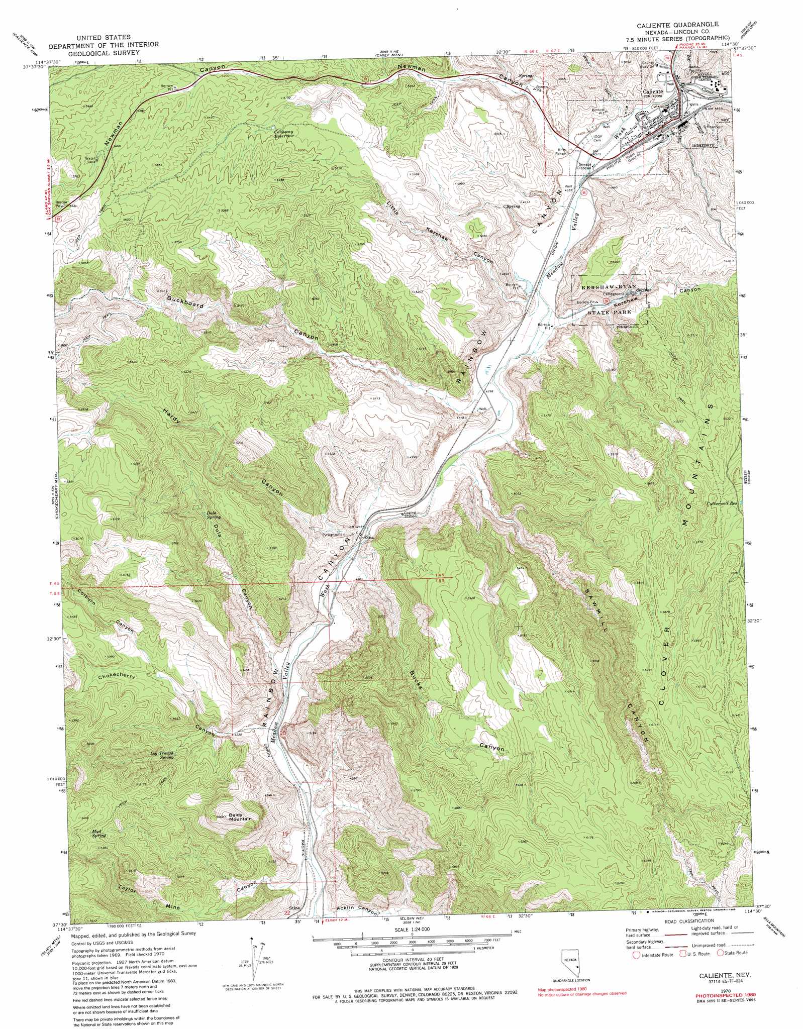
USGS Topo Quad 37114e5 - 1:24,000 scale
| Topo Map Name: | Caliente |
| USGS Topo Quad ID: | 37114e5 |
| Print Size: | ca. 21 1/4" wide x 27" high |
| Southeast Coordinates: | 37.5° N latitude / 114.5° W longitude |
| Map Center Coordinates: | 37.5625° N latitude / 114.5625° W longitude |
| U.S. State: | NV |
| Filename: | o37114e5.jpg |
| Download Map JPG Image: | Caliente topo map 1:24,000 scale |
| Map Type: | Topographic |
| Topo Series: | 7.5´ |
| Map Scale: | 1:24,000 |
| Source of Map Images: | United States Geological Survey (USGS) |
| Alternate Map Versions: |
Caliente NV 1970, updated 1973 Download PDF Buy paper map Caliente NV 1970, updated 1986 Download PDF Buy paper map Caliente NV 2012 Download PDF Buy paper map Caliente NV 2014 Download PDF Buy paper map |
1:24,000 Topo Quads surrounding Caliente
Deadman Spring Se |
The Bluffs |
Bennett Pass |
Panaca |
Condor Canyon |
Pahroc Spring Ne |
Caliente Nw |
Chief Mountain |
Indian Cove |
Mosey Mountain |
Pahroc Spring Se |
Chokecherry Mountain |
Caliente |
Eccles |
Islen |
Delamar |
Slidy Mountain |
Elgin Ne |
Ella Mountain |
Fife Mountain |
Gregerson Basin |
Elgin Sw |
Elgin |
Leith |
Garden Spring |
> Back to 37114e1 at 1:100,000 scale
> Back to 37114a1 at 1:250,000 scale
> Back to U.S. Topo Maps home
Caliente topo map: Gazetteer
Caliente: Mines
Sunset Mine elevation 1382m 4534′Caliente: Parks
Kershaw-Ryan State Park elevation 1374m 4507′Rose Memorial Park elevation 1339m 4393′
Caliente: Populated Places
Caliente elevation 1343m 4406′Etna elevation 1291m 4235′
Kershaw (historical) elevation 1376m 4514′
Strawberry Hill elevation 1347m 4419′
Caliente: Post Offices
Caliente Post Office elevation 1343m 4406′Stine Post Office (historical) elevation 1253m 4110′
Caliente: Reservoirs
Conaway Reservoir elevation 1570m 5150′Culverwell Reservoir elevation 1668m 5472′
Caliente: Springs
Caliente Hot Springs elevation 1347m 4419′Conway Spring elevation 1429m 4688′
Dula Spring elevation 1460m 4790′
Log Trough Spring elevation 1379m 4524′
Mud Spring elevation 1598m 5242′
Caliente: Streams
Clover Creek elevation 1342m 4402′Caliente: Summits
Baldy Mountain elevation 1713m 5620′Caliente: Valleys
Acklin Canyon elevation 1243m 4078′Buckboard Canyon elevation 1318m 4324′
Bucks Canyon elevation 1290m 4232′
Chokecherry Canyon elevation 1271m 4169′
Clover Creek Canyon elevation 1342m 4402′
Colburn Canyon elevation 1398m 4586′
Dula Canyon elevation 1280m 4199′
Hardy Canyon elevation 1306m 4284′
Kershaw Canyon elevation 1315m 4314′
Little Kershaw Canyon elevation 1329m 4360′
Mud Spring Canyon elevation 1287m 4222′
Newman Canyon elevation 1344m 4409′
Sawmill Canyon elevation 1292m 4238′
Taylor Mine Canyon elevation 1257m 4124′
Caliente digital topo map on disk
Buy this Caliente topo map showing relief, roads, GPS coordinates and other geographical features, as a high-resolution digital map file on DVD: