Prohibition Flat Topo Map Nevada
To zoom in, hover over the map of Prohibition Flat
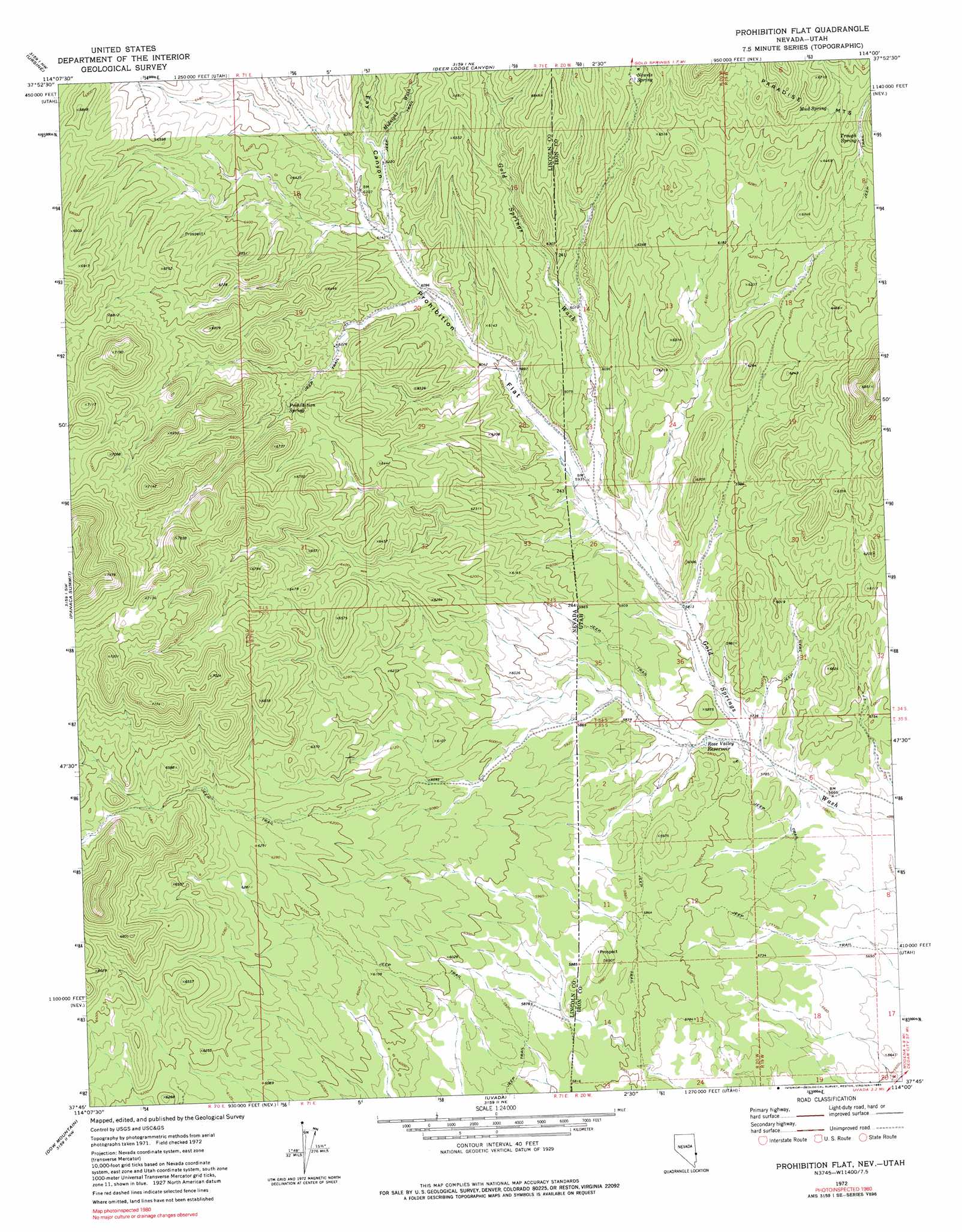
USGS Topo Quad 37114g1 - 1:24,000 scale
| Topo Map Name: | Prohibition Flat |
| USGS Topo Quad ID: | 37114g1 |
| Print Size: | ca. 21 1/4" wide x 27" high |
| Southeast Coordinates: | 37.75° N latitude / 114° W longitude |
| Map Center Coordinates: | 37.8125° N latitude / 114.0625° W longitude |
| U.S. States: | NV, UT |
| Filename: | o37114g1.jpg |
| Download Map JPG Image: | Prohibition Flat topo map 1:24,000 scale |
| Map Type: | Topographic |
| Topo Series: | 7.5´ |
| Map Scale: | 1:24,000 |
| Source of Map Images: | United States Geological Survey (USGS) |
| Alternate Map Versions: |
Prohibition Flat NV 1972, updated 1974 Download PDF Buy paper map Prohibition Flat NV 1972, updated 1990 Download PDF Buy paper map Prohibition Flat NV 2011 Download PDF Buy paper map Prohibition Flat NV 2012 Download PDF Buy paper map Prohibition Flat NV 2014 Download PDF Buy paper map |
1:24,000 Topo Quads surrounding Prohibition Flat
Pierson Summit |
Eagle Valley Reservoir |
Rice Mountain |
Steamboat Mountain Sw |
Steamboat Mountain |
Rose Valley |
Ursine |
Deer Lodge Canyon |
Eightmile Spring |
Bannion Spring |
Condor Canyon |
Panaca Summit |
Prohibition Flat |
Modena |
Heist |
Mosey Mountain |
Dow Mountain |
Uvada |
Mount Escalante |
Pinon Point |
Islen |
Acoma |
Pine Park |
Water Canyon Peak |
Hebron |
> Back to 37114e1 at 1:100,000 scale
> Back to 37114a1 at 1:250,000 scale
> Back to U.S. Topo Maps home
Prohibition Flat topo map: Gazetteer
Prohibition Flat: Flats
Prohibition Flat elevation 1844m 6049′Prohibition Flat: Mines
Blue Ridge Mine elevation 2146m 7040′Prohibition Flat: Reservoirs
Rose Valley Reservoir elevation 1751m 5744′Prohibition Flat: Springs
Hackett Spring elevation 1901m 6236′McGuffy Spring elevation 1980m 6496′
Mud Spring elevation 1969m 6459′
Newels Spring elevation 1954m 6410′
Prohibition Spring elevation 1954m 6410′
Trough Spring elevation 1955m 6414′
Prohibition Flat: Streams
Midnight Wash elevation 1913m 6276′Prohibition Flat: Valleys
Fay Canyon elevation 1877m 6158′Prohibition Flat digital topo map on disk
Buy this Prohibition Flat topo map showing relief, roads, GPS coordinates and other geographical features, as a high-resolution digital map file on DVD: