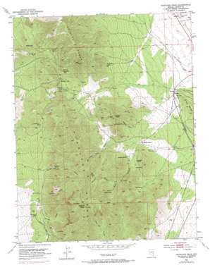
Highland Peak Topo Map Nevada
To zoom in, hover over the map of Highland Peak
USGS Topo Quad 37114h5 - 1:24,000 scale
| Topo Map Name: | Highland Peak |
| USGS Topo Quad ID: | 37114h5 |
| Print Size: | ca. 21 1/4" wide x 27" high |
| Southeast Coordinates: | 37.875° N latitude / 114.5° W longitude |
| Map Center Coordinates: | 37.9375° N latitude / 114.5625° W longitude |
| U.S. State: | NV |
| Filename: | o37114h5.jpg |
| Download Map JPG Image: | Highland Peak topo map 1:24,000 scale |
| Map Type: | Topographic |
| Topo Series: | 7.5´ |
| Map Scale: | 1:24,000 |
| Source of Map Images: | United States Geological Survey (USGS) |
| Alternate Map Versions: |
Highland Peak NV 1953, updated 1955 Download PDF Buy paper map Highland Peak NV 1953, updated 1971 Download PDF Buy paper map Highland Peak NV 2012 Download PDF Buy paper map Highland Peak NV 2014 Download PDF Buy paper map |
1:24,000 Topo Quads surrounding Highland Peak
> Back to 37114e1 at 1:100,000 scale
> Back to 37114a1 at 1:250,000 scale
> Back to U.S. Topo Maps home
Highland Peak topo map: Gazetteer
Highland Peak: Gaps
Manhattan Gap elevation 2189m 7181′Stampede Gap elevation 2228m 7309′
Highland Peak: Mines
Black Prince Mine elevation 1986m 6515′Blue Bell Mine elevation 2190m 7185′
Comet Mine elevation 1982m 6502′
Florence Mine elevation 2167m 7109′
Forlorn Hope Mine elevation 2156m 7073′
Hamburg Mine elevation 2242m 7355′
Highland Mary Mine elevation 2239m 7345′
Highland Queen Mine elevation 2185m 7168′
Last Chance Mine elevation 2228m 7309′
Log Cabin Mine elevation 2041m 6696′
Lucky Boy Shaft elevation 2212m 7257′
Manhattan Tunnel elevation 2206m 7237′
Mendha Mine elevation 2178m 7145′
Mountain Lion Mine elevation 2084m 6837′
Mountain Lion Number 29 Mine elevation 2161m 7089′
Non Pareil Mine elevation 1953m 6407′
Pioche Metals Mine elevation 1873m 6145′
Pioche Monitor Mines elevation 1873m 6145′
Schodde Mine elevation 2136m 7007′
Silver Comet Mine elevation 2239m 7345′
Stella Mine elevation 2239m 7345′
Tungsten Comet Mine elevation 2239m 7345′
X-Ray Tunnel elevation 2237m 7339′
Highland Peak: Populated Places
Big Trees elevation 2343m 7687′Highland (historical) elevation 2015m 6610′
Mendha elevation 1850m 6069′
Highland Peak: Ranges
Highland Range elevation 2856m 9370′Highland Peak: Springs
Connor Spring elevation 2337m 7667′Deadman Spring elevation 2089m 6853′
Floral Spring elevation 2060m 6758′
Highland Spring elevation 2123m 6965′
Lime Spring elevation 2110m 6922′
Pine Spring elevation 2206m 7237′
Highland Peak: Summits
Arizona Peak elevation 2391m 7844′Comet Peak elevation 2843m 9327′
Connor Peak elevation 2758m 9048′
Highland Peak elevation 2846m 9337′
McCullough Hill elevation 2030m 6660′
The Point elevation 1894m 6213′
Highland Peak: Valleys
Anderson Canyon elevation 2252m 7388′Burnt Canyon elevation 2253m 7391′
Burrows Canyon elevation 2027m 6650′
Dead Bull Canyon elevation 2399m 7870′
Lyndon Gulch elevation 2017m 6617′
One Wheel Canyon elevation 2060m 6758′
Peaslee Canyon elevation 2063m 6768′
Power Line Canyon elevation 2237m 7339′
Sheridan Canyon elevation 2058m 6751′
Water Canyon elevation 2016m 6614′
Wood Canyon elevation 2157m 7076′
Highland Peak digital topo map on disk
Buy this Highland Peak topo map showing relief, roads, GPS coordinates and other geographical features, as a high-resolution digital map file on DVD:


