Mount Irish Topo Map Nevada
To zoom in, hover over the map of Mount Irish
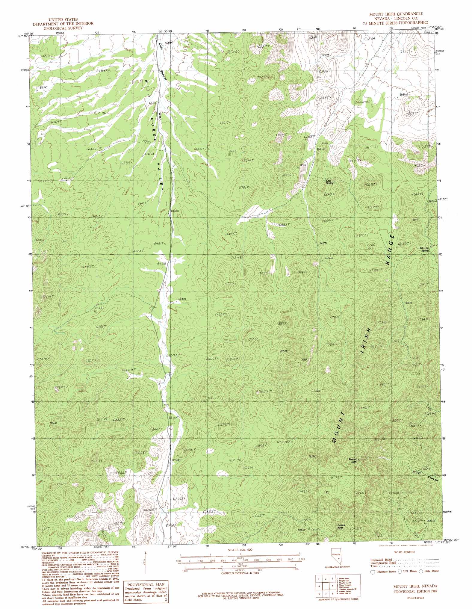
USGS Topo Quad 37115f4 - 1:24,000 scale
| Topo Map Name: | Mount Irish |
| USGS Topo Quad ID: | 37115f4 |
| Print Size: | ca. 21 1/4" wide x 27" high |
| Southeast Coordinates: | 37.625° N latitude / 115.375° W longitude |
| Map Center Coordinates: | 37.6875° N latitude / 115.4375° W longitude |
| U.S. State: | NV |
| Filename: | o37115f4.jpg |
| Download Map JPG Image: | Mount Irish topo map 1:24,000 scale |
| Map Type: | Topographic |
| Topo Series: | 7.5´ |
| Map Scale: | 1:24,000 |
| Source of Map Images: | United States Geological Survey (USGS) |
| Alternate Map Versions: |
Mount Irish NV 1985, updated 1986 Download PDF Buy paper map Mount Irish NV 2012 Download PDF Buy paper map Mount Irish NV 2014 Download PDF Buy paper map |
1:24,000 Topo Quads surrounding Mount Irish
Mccutchen Spring |
Worthington Peak |
Murphy Gap Nw |
Coal Valley Reservoir |
Oreana Spring |
Worthington Peak Sw |
Meeker Peak |
Murphy Gap |
Murphy Gap Se |
Seaman Wash |
Timpiute Mountain North |
Monte Mountain |
Mount Irish |
Mail Summit |
Fossil Peak |
Tempiute Mountain South |
Tempiute Mountain Se |
Crescent Spring |
Mount Irish Se |
Hiko |
Groom Range |
Groom Range Ne |
Crescent Reservoir |
Hancock Summit |
Ash Springs |
> Back to 37115e1 at 1:100,000 scale
> Back to 37114a1 at 1:250,000 scale
> Back to U.S. Topo Maps home
Mount Irish topo map: Gazetteer
Mount Irish: Gaps
Logan Pass elevation 2199m 7214′Mount Irish: Mines
Ora Lovell Mine elevation 2291m 7516′Rosario Mine elevation 2129m 6984′
Southpaw Mine elevation 2186m 7171′
Mount Irish: Springs
Camp Spring elevation 2061m 6761′Cold Spring elevation 1915m 6282′
Cold Spring elevation 1911m 6269′
Horse Springs elevation 1914m 6279′
Little Cut Spring elevation 1959m 6427′
Shaefer Spring elevation 1973m 6473′
Shingle Spring elevation 2295m 7529′
Tunnel Spring elevation 2078m 6817′
Mount Irish: Summits
Mount Irish elevation 2629m 8625′Sanderson Mountain elevation 2625m 8612′
Silver Hill elevation 2104m 6902′
Mount Irish digital topo map on disk
Buy this Mount Irish topo map showing relief, roads, GPS coordinates and other geographical features, as a high-resolution digital map file on DVD: