White Blotch Springs Ne Topo Map Nevada
To zoom in, hover over the map of White Blotch Springs Ne
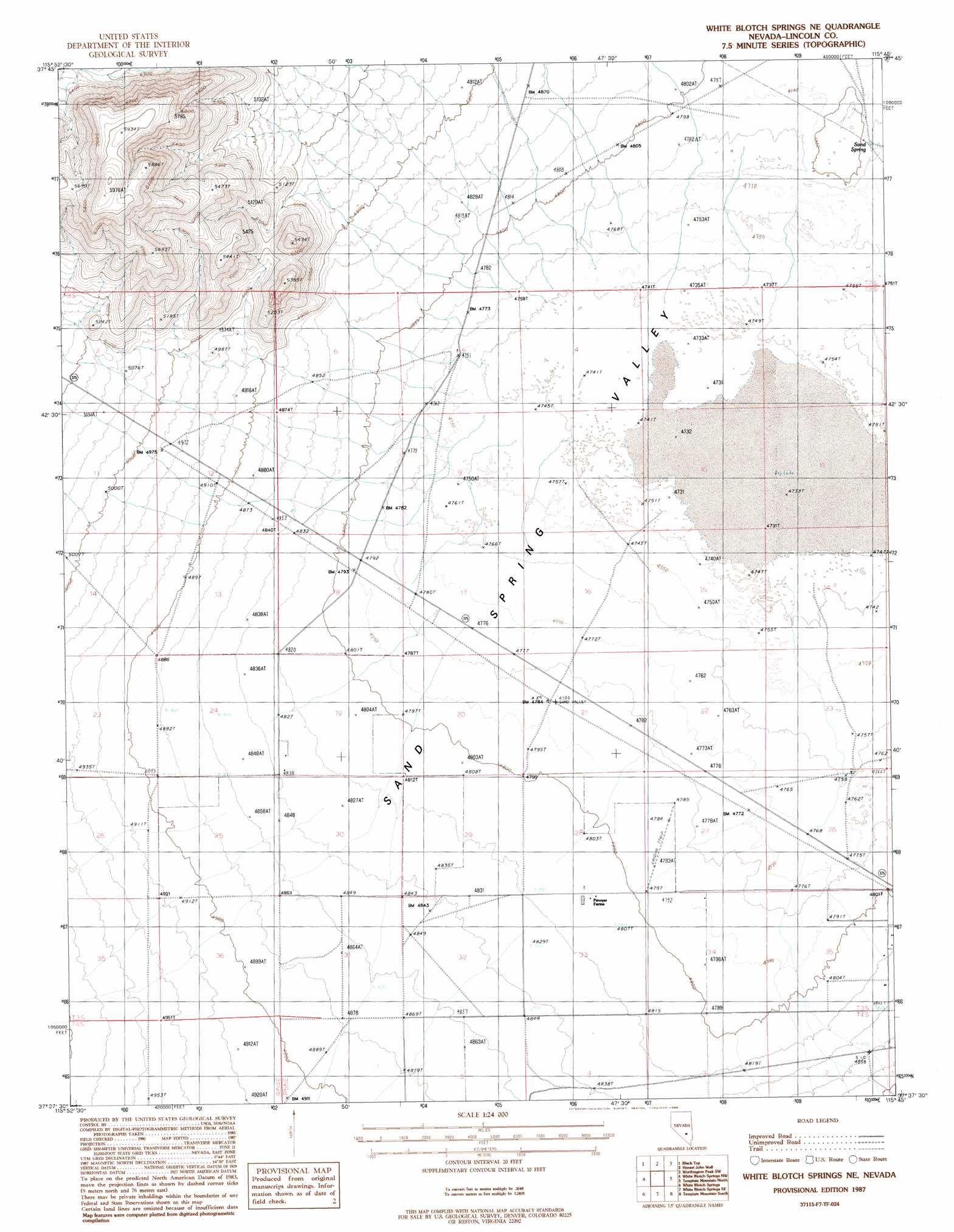
USGS Topo Quad 37115f7 - 1:24,000 scale
| Topo Map Name: | White Blotch Springs Ne |
| USGS Topo Quad ID: | 37115f7 |
| Print Size: | ca. 21 1/4" wide x 27" high |
| Southeast Coordinates: | 37.625° N latitude / 115.75° W longitude |
| Map Center Coordinates: | 37.6875° N latitude / 115.8125° W longitude |
| U.S. State: | NV |
| Filename: | o37115f7.jpg |
| Download Map JPG Image: | White Blotch Springs Ne topo map 1:24,000 scale |
| Map Type: | Topographic |
| Topo Series: | 7.5´ |
| Map Scale: | 1:24,000 |
| Source of Map Images: | United States Geological Survey (USGS) |
| Alternate Map Versions: |
White Blotch Springs NE NV 1987, updated 1988 Download PDF Buy paper map White Blotch Springs NE NV 2012 Download PDF Buy paper map White Blotch Springs NE NV 2015 Download PDF Buy paper map |
1:24,000 Topo Quads surrounding White Blotch Springs Ne
Freds Well |
Quinn Canyon Springs Nw |
Quinn Canyon Springs |
Mccutchen Spring |
Worthington Peak |
Reveille Peak Se |
Black Top |
Honest John Well |
Worthington Peak Sw |
Meeker Peak |
Monotony Valley |
White Blotch Springs Nw |
White Blotch Springs Ne |
Timpiute Mountain North |
Monte Mountain |
Belted Peak |
White Blotch Springs |
White Blotch Springs Se |
Tempiute Mountain South |
Tempiute Mountain Se |
Wheelbarrow Peak |
Groom Mine Nw |
Cattle Spring |
Groom Range |
Groom Range Ne |
> Back to 37115e1 at 1:100,000 scale
> Back to 37114a1 at 1:250,000 scale
> Back to U.S. Topo Maps home
White Blotch Springs Ne topo map: Gazetteer
White Blotch Springs Ne: Airports
Gunderson Strip elevation 1469m 4819′White Blotch Springs Ne: Basins
Sand Spring Valley elevation 1444m 4737′White Blotch Springs Ne: Populated Places
Sundown elevation 1479m 4852′White Blotch Springs Ne: Springs
Sand Spring elevation 1458m 4783′South Western Spring elevation 1484m 4868′
Sundown Spring elevation 1474m 4835′
White Blotch Springs Ne: Wells
Black Rock Well elevation 1450m 4757′Highway Well elevation 1477m 4845′
Number Six Well elevation 1452m 4763′
Southwestern Well elevation 1484m 4868′
White Blotch Springs Ne digital topo map on disk
Buy this White Blotch Springs Ne topo map showing relief, roads, GPS coordinates and other geographical features, as a high-resolution digital map file on DVD: