Tule Canyon Topo Map Nevada
To zoom in, hover over the map of Tule Canyon
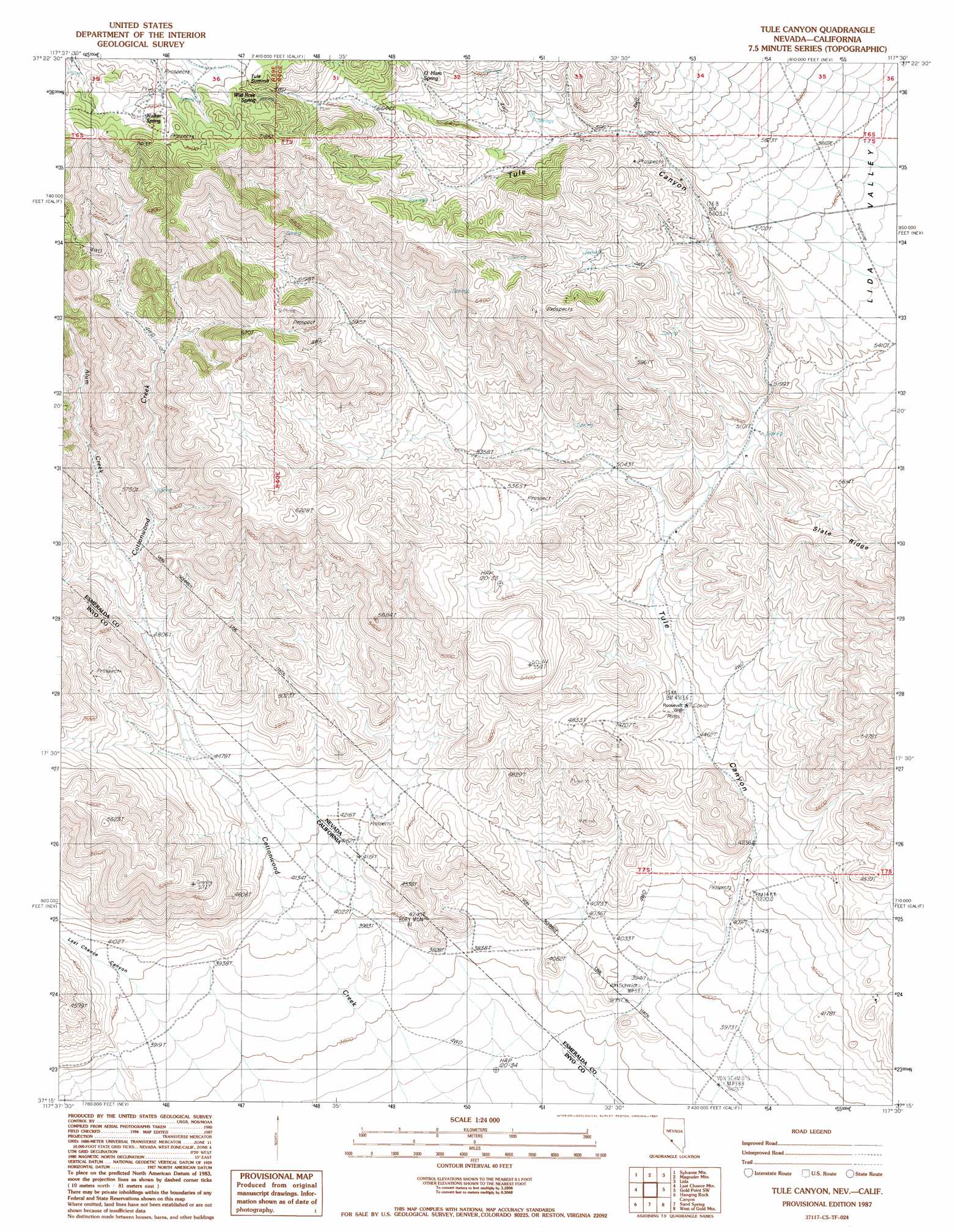
USGS Topo Quad 37117c5 - 1:24,000 scale
| Topo Map Name: | Tule Canyon |
| USGS Topo Quad ID: | 37117c5 |
| Print Size: | ca. 21 1/4" wide x 27" high |
| Southeast Coordinates: | 37.25° N latitude / 117.5° W longitude |
| Map Center Coordinates: | 37.3125° N latitude / 117.5625° W longitude |
| U.S. States: | NV, CA |
| Filename: | o37117c5.jpg |
| Download Map JPG Image: | Tule Canyon topo map 1:24,000 scale |
| Map Type: | Topographic |
| Topo Series: | 7.5´ |
| Map Scale: | 1:24,000 |
| Source of Map Images: | United States Geological Survey (USGS) |
| Alternate Map Versions: |
Tule Canyon NV 1987, updated 1987 Download PDF Buy paper map Tule Canyon NV 2011 Download PDF Buy paper map Tule Canyon NV 2014 Download PDF Buy paper map |
1:24,000 Topo Quads surrounding Tule Canyon
Oasis Divide |
Lida Wash Sw |
Lida Wash |
Montezuma Peak Sw |
Montezuma Peak Se |
Sylvania Canyon |
Sylvania Mountains |
Magruder Mountain |
Lida |
Mount Jackson |
Horse Thief Canyon |
Last Chance Mountain |
Tule Canyon |
Gold Point Sw |
Gold Point |
East Of Joshua Flats |
Hanging Rock Canyon |
Sand Spring |
West Of Gold Mountain |
Gold Mountain |
East Of Waucoba Spring |
Last Chance Range Sw |
Last Chance Range Se |
Ubehebe Crater |
Scottys Castle |
> Back to 37117a1 at 1:100,000 scale
> Back to 37116a1 at 1:250,000 scale
> Back to U.S. Topo Maps home
Tule Canyon topo map: Gazetteer
Tule Canyon: Gaps
Tule Summit elevation 2200m 7217′Tule Canyon: Mines
Mercer Brothers Mine elevation 1412m 4632′Oriental Mine elevation 1275m 4183′
Roosevelt Mine elevation 1468m 4816′
Six Bits Mine elevation 1321m 4333′
Tule Canyon: Post Offices
Tule Post Office elevation 1872m 6141′Tule Canyon: Ranges
Cucomungo Mountains elevation 1886m 6187′Tule Canyon: Springs
O'Hara Spring elevation 2012m 6601′Stockade Spring elevation 2182m 7158′
Walker Spring elevation 2223m 7293′
Wild Rose Spring elevation 2222m 7290′
Tule Canyon: Streams
Alum Creek elevation 1531m 5022′Cottonwood Creek elevation 1985m 6512′
Tule Canyon: Trails
Pipers Toll Road (historical) elevation 1852m 6076′Tule Canyon: Valleys
Last Chance Canyon elevation 1228m 4028′Tule Canyon elevation 1281m 4202′
Tule Canyon: Wells
Roosevelt Well elevation 1378m 4520′Tule Canyon digital topo map on disk
Buy this Tule Canyon topo map showing relief, roads, GPS coordinates and other geographical features, as a high-resolution digital map file on DVD: